List of protected heritage sites in Pont-à-Celles
This table shows an overview of the protected heritage sites in the Walloon town Pont-à-Celles. This list is part of Belgium's national heritage.
| Object |
Year/architect |
Town/section |
Address |
Coordinates |
Number? |
Image |
|---|---|---|---|---|---|---|
| rectory (nl) (fr) |
Pont-à-celles | Pont-a-Celles | 50.511773°N 4.364046°E |
52055-CLT-0001-01 Info |
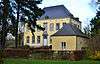 Pastorie | |
| Organ in the Church of Sainte-Vierge (nl) (fr) |
Pont-à-celles | Obaix | 50.527573°N 4.362723°E |
52055-CLT-0002-01 Info |
||
| Ensemble of "Terre à l'Danse" (nl) (fr) |
Pont-à-celles | Pont-à-Celles | 50.486310°N 4.422241°E |
52055-CLT-0003-01 Info |
||
| Chapel of Sainte Anne, protection around entire plot n ° 114 around the chapel (nl) (fr) |
Pont-à-celles | Luttre | 50.512703°N 4.386045°E |
52055-CLT-0005-01 Info |
.jpg) Kapel Sainte Anne, beschermingszone rond hele perceel n°114 rond de kapel | |
| Site "Bons Villers" (nl) (fr) |
Pont-à-celles | Liberchies | 50.507694°N 4.440170°E |
52055-CLT-0006-01 Info |
||
| Site of castellum: area of special value (nl) (fr) |
Pont-à-celles | Liberchies-Brunehault | 50.505226°N 4.429405°E |
52055-CLT-0007-01 Info |
||
| The main facade and the roof of Art Nouveau house on the rue des Ecoles No. 26 in Pont-a-Celles, (except the outhouse right) and the window in the door at the rear, a protection zone established around the house (nl) (fr) |
Pont-à-celles | 50.512407°N 4.359067°E |
52055-CLT-0008-01 Info |
 De hoofdgevel en het dak van huis Art Nouveau aan de rue des Ecoles nr. 26 in Pont-a-Celles, (met uitzondering van het bijgebouw rechts) en het raam in de deur aan de achterzijde, een beschermingsgebied vastgelegd rond het huis | ||
| Facades and roofs of the chapel of Notre-Dame de la Charité (nl) (fr) |
Pont-à-celles | rue de Scoumont te Obaix-Rosseignes | 50.543628°N 4.310054°E |
52055-CLT-0009-01 Info |
||
| Facades and roofs of the local school, setting conservation (nl) (fr) |
Pont-à-celles | rue Fond Nachez n°1 te Thiméon | 50.489988°N 4.428407°E |
52055-CLT-0010-01 Info |
 Gevels en daken lokale school, beschermingszone ingesteld | |
| Facades and roofs of the farm of the diocese (nl) (fr) |
Pont-à-celles | chaussée de Fleurus 29, te Thiméon | 50.491156°N 4.430626°E |
52055-CLT-0011-01 Info |
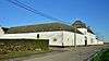 Gevels en daken van de boerderij van het bisdom | |
| Archaeological site of Liberchies: area of special value (nl) (fr) |
Pont-à-celles | 50.507694°N 4.440170°E |
52055-PEX-0001-01 Info |
|||
| Archaeological site of Liberchies: area of special value (nl) (fr) |
Pont-à-celles | 50.505226°N 4.429405°E |
52055-PEX-0002-01 Info |
See also
- List of protected heritage sites in Hainaut (province)
- Pont-à-Celles
| Wikimedia Commons has media related to Cultural heritage monuments in Pont-à-Celles. |
References
- Belgian heritage register: Direction générale opérationnelle - Aménagement du territoire, Logement, Patrimoine et Energie (DG4)
- www.dglive.be
This article is issued from Wikipedia. The text is licensed under Creative Commons - Attribution - Sharealike. Additional terms may apply for the media files.