List of protected heritage sites in Plombières
This table shows an overview of the protected heritage sites in the Walloon town Plombières. This list is part of Belgium's national heritage.
| Object |
Year/architect |
Town/section |
Address |
Coordinates |
Number? |
Image |
|---|---|---|---|---|---|---|
| Church Organs of Saint-Remy (nl) (fr) |
Plombières | rue du Village, n°70 | 50.720954°N 5.988853°E |
63088-CLT-0001-01 Info |
||
| Church Saint-Etienne: Interior (nl) (fr) |
Plombières | 50.707806°N 5.962630°E |
63088-CLT-0004-01 Info |
 Kerk Saint-Etienne: interieur | ||
| Streversdorp castle or Schlossgraaf (nl) (fr) |
Plombières | rue du château de Graaf, n°74 | 50.699629°N 5.944719°E |
63088-CLT-0005-01 Info |
.JPG) Kasteel Streversdorp of Schlossgraaf | |
| Broich castle (nl) (fr) |
Plombières | rue du château de Broich, n°36 | 50.705100°N 5.941840°E |
63088-CLT-0006-01 Info |
.JPG) Kasteel Broich | |
| Streversdorp castle with its surroundings (nl) (fr) |
Plombières | 50.699720°N 5.941488°E |
63088-CLT-0007-01 Info |
|||
| Castle Beusdael except the gate, and the surrounding area (nl) (fr) |
Plombières | 50.751214°N 5.910517°E |
63088-CLT-0010-01 Info |
.JPG) Kasteel van Beusdael, uitgezonderd het portaal, en het ensemble gevormd door het kasteel en het omliggende terrein | ||
| House: façades and roofs, except recent work on either side of the façade (nl) (fr) |
Plombières | rue du Chemin de fer, n°25 | 50.733963°N 5.964594°E |
63088-CLT-0011-01 Info |
.JPG) Huis: gevels en daken, behalve de recente aan weerszijde van de gevel | |
| Chapel of the Castle: walls and roof (nl) (fr) |
Plombières | rue du Château de Broich | 50.704587°N 5.941810°E |
63088-CLT-0012-01 Info |
Kapel van het kasteel: gevels en dak | |
| Veltjaeren Castle: walls and roofs, bridges, walls, and surroundings (nl) (fr) |
Plombières | rue Vieljaren, n°8 | 50.708276°N 5.905204°E |
63088-CLT-0013-01 Info |
.JPG) Kasteel Veltjaeren: gevels en daken, brug, muren en het ensemble van het kasteel met zijn omgeving | |
| Gothic cross (nl) (fr) |
Plombières | rue du Village (today rue du Centre) | 50.723913°N 5.920372°E |
63088-CLT-0014-01 Info |
.JPG) Gotisch kruis | |
| Organs of the church Notre-Dame de l'Assomption (nl) (fr) |
Plombières | 50.738228°N 5.961144°E |
63088-CLT-0015-01 Info |
.JPG) Orgels van kerk Notre-Dame de l’Assomption | ||
| House: everything with the exception of the extension at the rear of the barn (nl) |
Plombières | rue du Village, n°24/25 (today rue du Centre, n°65-67) | 50.722882°N 5.921166°E |
63088-CLT-0016-01 Info |
.JPG) Huis: zijgevels, dak en ensemble van het geheel, met uitzondering van de aanbouw aan de achterzijde van de schuur | |
| Farm house: walls and roofs (nl) (fr) |
Plombières | Kinkenweg no. 86 | 50.694398°N 5.940897°E |
63088-CLT-0017-01 Info |
 Huis van boerderij: gevels en daken, Kinkenweg n°86 | |
| Certain parts of the building, rue de Moresnet n ° 17-19 (nl) (fr) |
Plombières | G. Demoulin Rue No.'s 31 and 37, directtion of Savoir | 50.709491°N 5.964258°E |
63088-CLT-0018-01 Info |
.JPG) Bepaalde delen van het gebouw, rue de Moresnet n°17-19 (op dit moment rue G. Demoulin n°s 31 en 37) te Savoir | |
| Home: walls, roofs and latrines on the facade facing the street (nl) (fr) |
Plombières | rue G. Demoulin, n°4 (formerly called "place communale n°43") (M) et établissement d'une zone de protection (ZP) | 50.707673°N 5.963663°E |
63088-CLT-0019-01 Info |
.JPG) Huis: gevels, daken en latrine aan de gevel aan de straatzijde | |
| Alensberg Castle: fifteenth century roofs, farm (bakery) on the Rue du Village n ° 11, and the exterior of the old farmhouse Langhaag Street No. 4 and park Alensberg (nl) (fr) |
Plombières | rue Langhaag n°4 (EA) | 50.719608°N 5.981077°E |
63088-CLT-0020-01 Info |
.JPG) Kasteel Alensberg: De hele donjon van het vijftiende eeuwse kasteel, oude delen en boerderij=bakkerij aan de Rue du Village n°11 en het exterieur van de oude boerderij Langhaag Street n°4 (EA) en het park Alensberg | |
| American Military Cemetery Hombourg-Vogelzanck and its surroundings (nl) (fr) |
Plombières | 50.708112°N 5.889368°E |
63088-CLT-0021-01 Info |
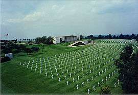 Militaire Amerikaanse Begraafplaats Hombourg-Vogelzanck en zijn omgeving |
See also
- List of protected heritage sites in Liège (province)
- Plombières
| Wikimedia Commons has media related to Cultural heritage monuments in Plombières. |
References
- Belgian heritage register: Direction générale opérationnelle - Aménagement du territoire, Logement, Patrimoine et Energie (DG4)
- www.dglive.be
This article is issued from Wikipedia. The text is licensed under Creative Commons - Attribution - Sharealike. Additional terms may apply for the media files.