List of protected heritage sites in Braine-le-Comte
This table shows an overview of the protected heritage sites in the Walloon town Braine-le-Comte. This list is part of Belgium's national heritage.
| Object |
Year/architect |
Town/section |
Address |
Coordinates |
Number? |
Image |
|---|---|---|---|---|---|---|
| Forest "Bois de la Houssière" (nl) (fr) |
's Gravenbrakel | 50.620777°N 4.175633°E |
55004-CLT-0001-01 Info |
|||
| 4 prehistoric tombs (nl) (fr) |
's Gravenbrakel | 50.620270°N 4.198845°E |
55004-CLT-0002-01 Info |
|||
| Old church of the Dominicans (nl) (fr) |
's Gravenbrakel | 50.609854°N 4.135386°E |
55004-CLT-0003-01 Info |
Oude kerk van de Dominicanen | ||
| Church of Saint-Gery (nl) (fr) |
's Gravenbrakel | 50.612904°N 4.137078°E |
55004-CLT-0004-01 Info |
 Kerk Saint-Géry | ||
| Old Town Hall, also known as the Hotel d'Arne Berg called main front facade and roof (nl) (fr) |
's Gravenbrakel | 50.610609°N 4.136668°E |
55004-CLT-0005-01 Info |
Oude raadhuis, ook wel Hôtel d'Arnenberg genoemd: hoofdgevel en voorzijde dak | ||
| Castle of Salmon Sart and surroundings (nl) (fr) |
's Gravenbrakel | chaussée de Mons n° 128-130 | 50.592154°N 4.098273°E |
55004-CLT-0006-01 Info |
||
| The remains of the ancient ramparts of the town of Braine-le-Comte, namely the three semicircular towers rose Larcee and another semicircular tower located in "rue des Fosses-Bass" (nl) (fr) |
's Gravenbrakel | 50.610186°N 4.138524°E |
55004-CLT-0007-01 Info |
|||
| Ensemble of the church Saint-Géry and surrounding wall (nl) (fr) |
Ronquieres 's Gravenbrakel | 50.608888°N 4.221401°E |
55004-CLT-0010-01 Info |
 Ensemble van de kerk Saint-Géry en omliggende muur | ||
| St. Martin's Church (nl) (fr) |
Steenkerke 's Gravenbrakel | 50.642623°N 4.069092°E |
55004-CLT-0012-01 Info |
Kerk Saint-Martin | ||
| Former convent of the Dominicans: facades and roofs and the ensemble of these buildings and the environment (nl) (fr) |
's Gravenbrakel | 50.609534°N 4.135661°E |
55004-CLT-0013-01 Info |
|||
| Station: facades and roofs and row of trees (nl) (fr) |
's Gravenbrakel | Place René Branquart | 50.605759°N 4.138225°E |
55004-CLT-0014-01 Info |
||
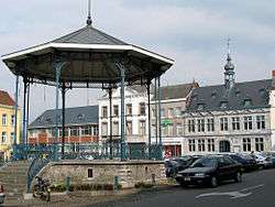
| Kiosk Grand 'Place (nl) (fr) |
's Gravenbrakel | Grand' Place | 50.610592°N 4.135913°E |
55004-CLT-0016-01 Info |
 Kiosk Grand' Place | |
| Chapel Notre-Dame du Refuge (nl) (fr) |
's Gravenbrakel | rue de Turenne, n° 1 (M) et alentours (S) | 50.637038°N 4.069139°E |
55004-CLT-0017-01 Info |
||
| Chapel Notre-Dame de Grâce and environment (nl) (fr) |
's Gravenbrakel | 50.598462°N 4.189981°E |
55004-CLT-0018-01 Info |
|||
| Facade, roof and machinery of the mill called "Moulin de Cambron et d'Arenberg" environment and the river at the rear of the building (nl) (fr) |
's Gravenbrakel | 50.608047°N 4.220996°E |
55004-CLT-0019-01 Info |
|||
| Entire facade and roof, including the chassis, woodwork, ironwork of the house "Art Nouveau" (nl) (fr) |
's Gravenbrakel | Rue Neuman n°51 | 50.609937°N 4.139545°E |
55004-CLT-0020-01 Info |
||
| Chapel of Bon Dieu de Pitie and the rock of Chenu (nl) (fr) |
's Gravenbrakel | 50.608178°N 4.225981°E |
55004-CLT-0021-01 Info |
|||
| The disused clay pit in one place "le Grand Bois" (nl) (fr) |
's Gravenbrakel | Hennuyères | 50.650966°N 4.190814°E |
55004-CLT-0022-01 Info |
||
| Sand quarry of Planois (extending woods of la Houssière) (nl) (fr) |
Hennuyères 's Gravenbrakel | 50.629466°N 4.184786°E |
55004-CLT-0023-01 Info |
|||
| Entire facade and roof, including the chassis, woodwork, ironwork of the house "Art Nouveau" (nl) (fr) |
's Gravenbrakel | Rue Neuman n°53 | 50.609979°N 4.139622°E |
55004-CLT-0024-01 Info |
||
| Entire facade and roof, including the chassis, woodwork, ironwork of the house "Art Nouveau" (nl) (fr) |
's Gravenbrakel | Rue Neuman n°55 | 50.610010°N 4.139684°E |
55004-CLT-0025-01 Info |
||
| Entire facade and roof, including the chassis, woodwork, ironwork of the house "Art Nouveau" (nl) (fr) |
's Gravenbrakel | Rue Neuman n°57 | 50.610053°N 4.139747°E |
55004-CLT-0026-01 Info |
||
| Entire facade and roof, including the chassis, woodwork, ironwork of the house "Art Nouveau" (nl) (fr) |
's Gravenbrakel | Rue Neuman n°59 | 50.610088°N 4.139804°E |
55004-CLT-0027-01 Info |
||
| Entire facade and roof, including the chassis, woodwork, ironwork of the house "Art Nouveau" (nl) (fr) |
's Gravenbrakel | Rue Neuman n°61 | 50.610117°N 4.139864°E |
55004-CLT-0028-01 Info |
||
| Entire facade and roof, including the chassis, woodwork, ironwork of the house "Art Nouveau" (nl) (fr) |
's Gravenbrakel | Rue Neuman n°63 | 50.610152°N 4.139932°E |
55004-CLT-0029-01 Info |
See also
- List of protected heritage sites in Hainaut (province)
- Braine-le-Comte
| Wikimedia Commons has media related to Cultural heritage monuments in Braine-le-Comte. |
References
- Belgian heritage register: Direction générale opérationnelle - Aménagement du territoire, Logement, Patrimoine et Energie (DG4)
- www.dglive.be
This article is issued from Wikipedia. The text is licensed under Creative Commons - Attribution - Sharealike. Additional terms may apply for the media files.