List of parks in Bern
The city of Bern, Switzerland, has 130 urban parks and 95 public playgrounds with a total surface area of 4.2 square kilometres (1,000 acres).[1] These venues are maintained by the City Nursery (Stadtgärtnerei).
Principal parks
Inner City
In the Old City, the most prominent green spaces are those on the sunny southern ridge of the Old City peninsula. From west to east, these are the Kleine Schanze, the Bundesterrasse, the privately owned Casinoterrasse and the Münsterplattform.[2]
Bundesterrasse
The Bundesterrasse (Federal Terrace) is the terrace on the south, Aar-facing front of the Federal Palace of Switzerland, the building housing the Swiss federal parliament and several federal executive departments. The terrace follows the ridge of the Old City peninsula from the Kleine Schanze in the west to the Hotel Bellevue Palace and the Kirchenfeldbrücke in the east.
List of parks
This partial list is taken from the website of the City Nursery.[3] Coordinates are derived from the city GIS.[4]
| Image | Name | Location | Notes | |
|---|---|---|---|---|
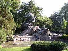
| Bundesterrasse | 46.9460°N 7.4431°E | Terrace south of the Federal Palace, overlooking the River Aar and the Marzili neighborhood. | ||
 |
Münsterplattform | 46.9468°N 7.4518°E | Terrace south of the cathedral, the Münster of Bern, overlooking the Aar and the Matte neighborhood. (Images) | |
 |
Kleine Schanze | 46.9456°N 7.4404°E | Part of the former city fortifications (Schanze), now the Old City of Bern's principal park, with numerous monuments and a bandstand. | |
| Schütte | 46.9496°N 7.4487°E | The northern slope of the Aar peninsula between Lorrainebrücke and the Nydegg neighborhood, currently in the process of restoration. | ||
| Aaregg Kinderspielplatz II | 46.9729°N 7.4522°E | Small public playground. | ||
| Hintere Engehalde | 46.9703°N 7.447°E | |||
| Engepromenade | 46.9640°N 7.4417°E | |||
| Rossfeld Park | ||||
 |
Grosse Schanze | 46.9499°N 7.4388°E | Formerly part of the city fortifications, now a large roof terrace in front of the University of Bern's main building. | |
| Studerstein | 46.9625°N 7.4333°E | Arboretum founded in 1809 with 350 species of tree. Monument to mountaineer and draftsman Gottlieb Samuel Studer (1804-1890). | ||
| Alter Tierpark | 46.9563°N 7.4387°E | From 1881 to 1937 a small zoo (Hirschenpark) with deer and bisons. | ||
| Bürenpark | 46.9385°N 7.4393°E | Small park near a church community building. | ||
| Floraanlage | 46.9430°N 7.4370°E | Small park near the U.S. embassy. | ||
| Gaswerkareal | 46.9374°N 7.4429°E | Large recreational area with sports facilities on the bank of the river Aar, near the Gaskessel cultural venue. | ||
| Goumoensmatte Spielplatz | 46.9341°N 7.4295°E | Small public lawn and playground. | ||
| Kocherpark | 46.9464°N 7.4329°E | Named after physician and Nobel laureate Theodor Kocher (1841–1917). | ||
 |
Lentulushubel | 46.9378°N 7.4250°E | Grave of General Rupertus Scipio Lentulus (1714–1786) on a small hillock. | |
| Monbijou Park | 46.9421°N 7.4348°E | Park and playground behind the Oberzolldirektion. | ||
| Schlossmatt Spielplatz | 46.9435°N 7.4150°E | Small public lawn and playground among residential buildings. | ||
 |
Schwarztoranlage | 46.9446°N 7.4311°E | Small tree-lined park on a busy street. | |
 |
Steinhölzli Spielplatz | 46.9359°N 7.4254°E | Public playground near a small forest. | |
 |
Veielihubel | 46.9440°N 7.4226°E | Small park area on a hillock providing a view over part of the city. | |
| Dalmaziquai | 46.9369°N 7.44513°E | Riverwalk on the eastern shore of the Aar near the Tierpark Dählhölzli. | ||
| Egelsee | 46.9445°N 7.4649°E | |||
| Elfenau | 46.9329°N 7.4657°E | |||
| Jupiterstrasse | 46.9392°N 7.4825°E | |||
| N6–Überdeckung | 46.9427°N 7.4733°E | |||
| Rosengarten | 46.9519°N 7.4603°E | |||
| Schönbergpark | 46.9501°N 7.4645°E | |||
| Traffeletweg | 46.9472°N 7.4748°E | |||
| Grosse Allmend | 46.9622°N 7.4701°E | |||
| Kleine Allmend | 46.9602°N 7.4761°E | |||
| Breitenrain Park | 46.9573°N 7.4488°E | |||
| Obere Humboldtstrasse | 46.9532°N 7.4555°E | |||
| Johanneskirche | 46.9575°N 7.4500°E | |||
| Schützenweg | ||||
| Spitalackerpark | ||||
| Bachmätteli und SVB | ||||
| Bethlehem Park | ||||
| Brünnen Tunnelüberdeckung | ||||
| Bümpliz Schlosspark | ||||
| Schwabgut | ||||
| Tscharnergut | ||||
| Winterhalde |
External links
| Wikimedia Commons has media related to Parks in Bern. |
- "Stadtgärtnerei Bern" (in German). Archived from the original on 2010-03-16. Retrieved 2010-03-07.
References
- "Stadtgärtnerei: Grünflächenpflege" (in German). Archived from the original on 17 March 2010. Retrieved 7 March 2010.
- Weilacher, Udo; Wullschleger, Peter (2002). Landschaftsarchitekturführer Schweiz. Birkhäuser. p. 104. ISBN 978-3-7643-6587-5.
- "Stadtgärtnerei: Grünanlagen" (in German). Archived from the original on 15 March 2010. Retrieved 7 March 2010.
- "Stadtplan Bern". Retrieved 8 March 2010.