List of listed buildings in Pencaitland, East Lothian
List
| Name | Location | Date Listed | Grid Ref. [note 1] | Geo-coordinates | Notes | LB Number [note 2] | Image |
|---|---|---|---|---|---|---|---|
| Easter Pencaitland,1-4 (Inclusive) Ivy Cottage | 55°54′41″N 2°53′10″W | Category C(S) | 18908 |  | |||
| Easter Pencaitland, 7, 8, 9, 10 Park View | 55°54′42″N 2°53′10″W | Category C(S) | 18910 | | |||
| 1-23 (Inclusive) New Winton Cottages | 55°55′47″N 2°55′14″W | Category B | 18929 | | |||
| Tyneholm House Stables | 55°54′28″N 2°53′33″W | Category B | 18938 | | |||
| Wester Pencaitland Cartshed And Granary | 55°54′35″N 2°53′48″W | Category C(S) | 18940 | | |||
| Winton House,Laundry Cottage | 55°55′00″N 2°53′55″W | Category B | 18949 | | |||
| Easter Pencaitland, Pencaitland War Memorial | 55°54′46″N 2°53′03″W | Category C(S) | 18911 | | |||
| Fountainhall Steading | 55°53′53″N 2°55′04″W | Category B | 18922 | | |||
| Wester Pencaitland Mercat Cross | 55°54′36″N 2°53′45″W | Category B | 18944 | | |||
| Winton House (Formerly Castle) With Terraces Railings | 55°54′55″N 2°54′02″W | Category A | 18948 | 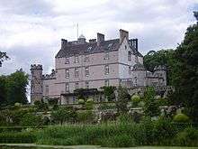 | |||
| Milton House | 55°53′42″N 2°52′28″W | Category B | 18928 | | |||
| Tyneholm House With Walled Garden | 55°54′30″N 2°53′07″W | Category B | 18936 | | |||
| Tyneholm House Lodge With Quadrant Walls And Gatepiers | 55°54′38″N 2°53′40″W | Category C(S) | 18937 | | |||
| Woodhall House With Terrace Wall And Railings | 55°54′09″N 2°54′57″W | Category C(S) | 18953 | | |||
| Peaston, Grieve's Cottage | 55°52′38″N 2°54′59″W | Category C(S) | 47448 | | |||
| Peaston Smithy And Smithy Houses | 55°52′39″N 2°54′58″W | Category C(S) | 47449 | | |||
| Easter Pencaitland, Old Penkaet House With Outbuildings, Gatepiers, Gates And Retaining Walls | 55°54′41″N 2°53′36″W | Category B | 18909 | | |||
| Easter Pencaitland,Schoolhouse And School With Railings | 55°54′42″N 2°53′07″W | Category B | 18915 | | |||
| Easter Pencaitland,Winton House,South Lodge Gates And Gatepiers | 55°54′42″N 2°53′23″W | Category A | 18917 | | |||
| Fountainhall Or Penkaet Castle, With Garden Walls And Gatepiers | 55°53′54″N 2°55′08″W | Category A | 18918 | | |||
| Fountainhall Cottages | 55°53′54″N 2°55′14″W | Category C(S) | 18919 | | |||
| Pencaitland Parish Church With Gatehouse Offertory Houses And Graveyard Walls And Gatepiers | 55°54′39″N 2°53′32″W | Category A | 18933 | 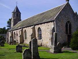 | |||
| Saltoun Hall,West Lodge And Gatepiers | 55°53′55″N 2°52′22″W | Category C(S) | 18935 | | |||
| Wester Pencaitland,Belfry Cottage And Old Schoolhouse With Retaining Walls And Railings | 55°54′37″N 2°53′43″W | Category B | 18939 | | |||
| Wester Pencaitland The Cross | 55°54′36″N 2°53′45″W | Category C(S) | 18941 | | |||
| Wester Pencaitland Trevelyan Cottage And Post Office | 55°54′35″N 2°53′44″W | Category C(S) | 18946 | | |||
| Wester Pencaitland Tyneholm Cottages | 55°54′35″N 2°53′43″W | Category C(S) | 18947 | | |||
| Wolfstar Farmhouse With Gatepiers | 55°54′24″N 2°56′06″W | Category B | 18952 | | |||
| Easter Pencaitland,Winton House,South Lodge | 55°54′42″N 2°53′24″W | Category B | 18916 | | |||
| Fountainhall Stables | 55°53′55″N 2°55′12″W | Category C(S) | 18921 | | |||
| Glenkinchie Distillery,Malt Barns (Museum)And Stalk | 55°53′28″N 2°53′28″W | Category B | 18923 | | |||
| Lempockwells Farmhouse | 55°53′49″N 2°52′59″W | Category B | 18926 | | |||
| Pencaitland Bridge | 55°54′39″N 2°53′38″W | Category B | 18931 | | |||
| Saltoun Hall Dovecot | 55°54′23″N 2°51′59″W | Category B | 18934 | | |||
| Wester Pencaitland Farm Dovecot | 55°54′37″N 2°53′49″W | Category A | 18942 | 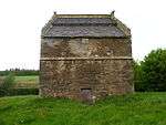 | |||
| Wester Pencaitland,Lempockwells Road Pencaet Workshop | 55°53′28″N 2°53′40″W | Category C(S) | 18943 | | |||
| Wester Pencaitland Temperance Hall With Railings | 55°54′37″N 2°53′45″W | Category C(S) | 18945 | | |||
| Winton House North Lodge With Gates | 55°55′12″N 2°54′21″W | Category A | 18950 | .jpg) | |||
| Easter Pencaitland,St Michaels Lodge With Retaining Walls And Gatepiers | 55°54′42″N 2°53′14″W | Category B | 18913 | | |||
| Peaston Farmhouse | 55°52′41″N 2°55′00″W | Category C(S) | 18930 | | |||
| Fountainhall Dovecots | 55°53′55″N 2°55′05″W | Category B | 18920 | | |||
| Huntlaw Farmhouse | 55°53′58″N 2°54′10″W | Category B | 18924 | | |||
| Huntlaw Steading | 55°53′56″N 2°54′07″W | Category B | 18925 | | |||
| Pencaitland Manse With Terrace Walls Gatepiers And Stable Court | 55°54′39″N 2°53′31″W | Category B | 18932 | | |||
| Winton House Stables | 55°55′00″N 2°54′01″W | Category C(S) | 18951 | | |||
| Easter Pencaitland, Penkaet House | 55°54′41″N 2°53′36″W | Category B | 18912 | | |||
| Milton Bridge | 55°53′31″N 2°52′07″W | Category B | 18927 | |
Key
The scheme for classifying buildings in Scotland is:
- Category A: "buildings of national or international importance, either architectural or historic; or fine, little-altered examples of some particular period, style or building type."[1]
- Category B: "buildings of regional or more than local importance; or major examples of some particular period, style or building type, which may have been altered."[1]
- Category C: "buildings of local importance; lesser examples of any period, style, or building type, as originally constructed or moderately altered; and simple traditional buildings which group well with other listed buildings."[1]
In March 2016 there were 47,288 listed buildings in Scotland. Of these, 8 per cent were Category A, and 50 per cent were Category B, with the rest listed at Category C.[2]
Notes
- Sometimes known as OSGB36, the grid reference (where provided) is based on the British national grid reference system used by the Ordnance Survey.
• "Guide to National Grid". Ordnance Survey. Retrieved 2007-12-12.
• "Get-a-map". Ordnance Survey. Retrieved 2007-12-17. - Historic Environment Scotland assign a unique alphanumeric identifier to each designated site in Scotland, for listed buildings this always begins with "LB", for example "LB12345".
References
- All entries, addresses and coordinates are based on data from Historic Scotland. This data falls under the Open Government Licence
- "What is Listing?". Historic Environment Scotland. Retrieved 29 May 2018.
- Scotland's Historic Environment Audit 2016 (PDF). Historic Environment Scotland and the Built Environment Forum Scotland. pp. 15–16. Retrieved 29 May 2018.
This article is issued from Wikipedia. The text is licensed under Creative Commons - Attribution - Sharealike. Additional terms may apply for the media files.