List of listed buildings in Kilmory, North Ayrshire
List
| Name | Location | Date Listed | Grid Ref. [note 1] | Geo-coordinates | Notes | LB Number [note 2] | Image |
|---|---|---|---|---|---|---|---|
| Isle Of Arran, Bennecarrigan, Free Church Of Scotland, Including Boundary Wall | 55°26′58″N 5°15′19″W | Category B | 13633 |  | |||
| Isle Of Arran, Dougarie Lodge, Game Larder | 55°34′58″N 5°21′31″W | Category B | 13045 | | |||
| Isle Of Arran, Shiskine, Torbeg, Former Manse | 55°31′10″N 5°19′37″W | Category B | 12882 | | |||
| Lagg Hotel | 55°26′45″N 5°14′02″W | Category C(S) | 7641 | | |||
| Lochranza Church And Graveyard | 55°42′05″N 5°17′05″W | Category B | 7634 |  | |||
| Row Of Cottages Nos. 1-12, Catacol And Front Garden Walls | 55°41′43″N 5°19′34″W | Category B | 7637 |  | |||
| Hazelwood Farm, Imachar, Near Pirnmill, Including Outbuildings | 55°36′40″N 5°23′26″W | Category C(S) | 49537 | | |||
| Isle Of Arran, Shiskine, Torbeg, Nicol Memorial | 55°31′08″N 5°19′32″W | Category C(S) | 13632 | | |||
| Bridgend Cottage | 55°26′43″N 5°14′00″W | Category C(S) | 13663 | | |||
| Kildonan, Project House (Former Church Of Scotland) Including Gatepiers And Boundary Wall | 55°26′51″N 5°07′58″W | Category C(S) | 13452 | | |||
| Kildonan, Drimla Cottage, Including Gatepiers, Gates And Railings | 55°26′37″N 5°07′30″W | Category C(S) | 13453 | | |||
| Lochranza, Barking House | 55°42′08″N 5°17′06″W | Category B | 13456 | | |||
| Kilmory Manse | 55°26′52″N 5°13′16″W | Category C(S) | 7640 | | |||
| St. Molio's Church Shiskine | 55°30′49″N 5°18′43″W | Category A | 7635 | 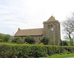 | |||
| Lochranza, Former Free Church | 55°42′15″N 5°17′34″W | Category C(S) | 13457 | | |||
| Isle Of Arran, Dippen, Dippen Lodge | 55°27′21″N 5°05′10″W | Category C(S) | 13043 | | |||
| Isle Of Arran, Shiskine, War Memorial | 55°30′23″N 5°19′09″W | Category C(S) | 12881 | | |||
| Lochranza Castle | 55°42′19″N 5°17′28″W | Category A | 7636 |  | |||
| Pirnmill, Former Church Of Scotland, Including Gatepiers And Boundary Walls | 55°38′43″N 5°22′55″W | Category B | 13489 | | |||
| Isle Of Arran, Blackwaterfoot, Victoria Lodge | 55°30′11″N 5°19′55″W | Category B | 13635 | | |||
| Isle Of Arran, Dippen, Dippen Lodge, Stable Court And Offices | 55°27′23″N 5°05′13″W | Category C(S) | 13044 | | |||
| Isle Of Arran, Dougarie Lodge, The Towers, (Stables And Kennels) | 55°34′58″N 5°21′31″W | Category B | 13046 | | |||
| Isle Of Arran, Machrie, Machrie Farmhouse | 55°33′09″N 5°19′37″W | Category B | 12880 | | |||
| Dougarie Lodge Boathouse | 55°34′47″N 5°21′38″W | Category B | 7639 | | |||
| Kildonan, Drimla Lodge, Including Gatepiers, Gates And Railings | 55°26′36″N 5°07′28″W | Category B | 13454 | | |||
| Kildonan, Mansfield | 55°26′39″N 5°07′54″W | Category C(S) | 13455 | | |||
| Kilmory Church And Graveyard | 55°26′53″N 5°13′19″W | Category C(S) | 7633 | | |||
| Dougrie Lodge | 55°34′53″N 5°21′34″W | Category B | 7638 | | |||
| Isle Of Arran, Bennecarrigan, War Memorial | 55°26′58″N 5°15′20″W | Category C(S) | 13634 | | |||
| Pirnmill, Former Church Of Scotland, Memorial To Rev John Kennedy | 55°38′43″N 5°22′55″W | Category B | 13479 | | |||
| Isle Of Arran, Dougarie Lodge, Walled Garden | 55°34′56″N 5°21′32″W | Category B | 12879 | | |||
| Burnside Cottage | 55°26′42″N 5°14′01″W | Category C(S) | 7642 | | |||
| Lime Kiln, Clauchog | 55°26′28″N 5°14′35″W | Category C(S) | 7643 | | |||
| Pirnmill, Church Of Scotland (Former Free Church) | 55°38′59″N 5°22′50″W | Category C(S) | 49535 |  |
Key
The scheme for classifying buildings in Scotland is:
- Category A: "buildings of national or international importance, either architectural or historic; or fine, little-altered examples of some particular period, style or building type."[1]
- Category B: "buildings of regional or more than local importance; or major examples of some particular period, style or building type, which may have been altered."[1]
- Category C: "buildings of local importance; lesser examples of any period, style, or building type, as originally constructed or moderately altered; and simple traditional buildings which group well with other listed buildings."[1]
In March 2016 there were 47,288 listed buildings in Scotland. Of these, 8 per cent were Category A, and 50 per cent were Category B, with the rest listed at Category C.[2]
Notes
- Sometimes known as OSGB36, the grid reference (where provided) is based on the British national grid reference system used by the Ordnance Survey.
• "Guide to National Grid". Ordnance Survey. Retrieved 2007-12-12.
• "Get-a-map". Ordnance Survey. Retrieved 2007-12-17. - Historic Environment Scotland assign a unique alphanumeric identifier to each designated site in Scotland, for listed buildings this always begins with "LB", for example "LB12345".
References
- All entries, addresses and coordinates are based on data from Historic Scotland. This data falls under the Open Government Licence
- "What is Listing?". Historic Environment Scotland. Retrieved 29 May 2018.
- Scotland's Historic Environment Audit 2016 (PDF). Historic Environment Scotland and the Built Environment Forum Scotland. pp. 15–16. Retrieved 29 May 2018.
This article is issued from Wikipedia. The text is licensed under Creative Commons - Attribution - Sharealike. Additional terms may apply for the media files.