List of listed buildings in Irvine, North Ayrshire
List
| Name | Location | Date Listed | Grid Ref. [note 1] | Geo-coordinates | Notes | LB Number [note 2] | Image |
|---|---|---|---|---|---|---|---|
| 28-32 (Even Nos) Ballot Road, Former Hosiery Factory | 55°36′58″N 4°39′38″W | Category C(S) | 44632 |  | |||
| 14 And 16 Burns Street | 55°37′06″N 4°40′09″W | Category C(S) | 44647 | | |||
| 22 Eglinton Street, Eglinton House | 55°37′02″N 4°40′06″W | Category B | 44659 | | |||
| 28 Eglinton Street, Irvine Burns Club | 55°37′03″N 4°40′07″W | Category B | 44660 | | |||
| High Street, War Memorial | 55°36′51″N 4°39′54″W | Category B | 44668 | | |||
| 131, 135 And 137 High Street | 55°36′55″N 4°40′04″W | Category C(S) | 44676 | | |||
| 153 And 155 High Street | 55°36′56″N 4°40′06″W | Category C(S) | 44680 | | |||
| 152 High Street | 55°36′56″N 4°40′03″W | Category C(S) | 44685 | | |||
| 55 Kirkgate | 55°36′48″N 4°40′01″W | Category C(S) | 44696 | | |||
| 32 Kilwinning Road Including Boundary Walls | 55°37′26″N 4°40′18″W | Category C(S) | 44703 | | |||
| 27-35 (Odd Nos) Townhead | 55°36′48″N 4°39′42″W | Category C(S) | 44709 | | |||
| 112 And 114 High Street, Eglinton Arms Hotel | 55°36′54″N 4°40′01″W | Category B | 35425 | | |||
| 19 Hill Street | 55°36′51″N 4°40′05″W | Category B | 35436 | | |||
| 21 Hill Street | 55°36′51″N 4°40′05″W | Category C(S) | 35437 | | |||
| 28 Castle Street, Castle Grange Including Boundary Walls | 55°37′02″N 4°40′14″W | Category B | 35440 | | |||
| 44 Harbour Street | 55°36′32″N 4°40′53″W | Category C(S) | 35446 | | |||
| Church Street, Fullarton Parish Church Including Former Schoolhouse | 55°36′51″N 4°40′31″W | Category C(S) | 35413 | | |||
| Towns Moor, Burns Statue | 55°37′16″N 4°40′26″W | Category B | 35418 | | |||
| Bank Street, Irvine Baptist Chapel | 55°36′56″N 4°39′56″W | Category C(S) | 44633 | | |||
| 79 And 81 Bank Street, Including Outbuildings, Boundary Walls And Gatepiers | 55°37′03″N 4°39′39″W | Category C(S) | 44640 | | |||
| 8, 10 And 12 Burns Street | 55°37′05″N 4°40′08″W | Category C(S) | 44646 | | |||
| 46, 48 And 50 Burns Street | 55°37′08″N 4°40′10″W | Category C(S) | 44651 | | |||
| Castle Street, Annfield, Including Outbuildings And Boundary Walls | 55°37′03″N 4°40′17″W | Category B | 44652 | | |||
| 7 And 9 Eglinton Street | 55°37′00″N 4°40′07″W | Category C(S) | 44657 | | |||
| 12-18 (Even Nos) Eglinton Street | 55°37′01″N 4°40′06″W | Category C(S) | 44658 | | |||
| 50 Harbour Street | 55°36′32″N 4°40′53″W | Category C(S) | 44664 | | |||
| 61 And 63 High Street | 55°36′51″N 4°39′58″W | Category C(S) | 44669 | | |||
| 148 High Street | 55°36′56″N 4°40′03″W | Category C(S) | 44684 | | |||
| Knadherhill Cemetery, Gate Lodge, Including Entrance, Gates, Gatepiers And Railings | 55°37′35″N 4°39′00″W | Category C(S) | 44704 | | |||
| 10 West Road Including Boundary Walls | 55°36′56″N 4°40′12″W | Category C(S) | 44716 | | |||
| 28 West Road, Violet Bank, Including Boundary Walls And Outbuildings | 55°36′59″N 4°40′16″W | Category C(S) | 44717 | | |||
| Queen's Bridge | 55°37′23″N 4°40′55″W | Category B | 35419 | | |||
| 57 And 59 High Street And 2 Kirkgate | 55°36′51″N 4°39′57″W | Category B | 35427 | | |||
| 45 Townhead | 55°36′49″N 4°39′46″W | Category B | 35428 | | |||
| 11 Seagate | 55°36′59″N 4°40′09″W | Category C(S) | 35439 | | |||
| Kirkgate, Irvine Old Parish Church And Graveyard, Including Boundary Walls And Gatepiers | 55°36′45″N 4°39′56″W | Category A | 35409 | 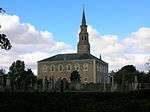 | |||
| Kidsneuk Cottage, 6, 7 Ravenspark Golf Course | 55°37′53″N 4°40′49″W | Category C(S) | 7644 | | |||
| Stane Castle | 55°37′29″N 4°38′30″W | Category B | 7645 | | |||
| Littlestone Farmhouse And Adjoining Farm Buildings, Lawthorn | 55°38′00″N 4°38′11″W | Category C(S) | 7649 | | |||
| 46 And 48 Harbour Street | 55°36′32″N 4°40′52″W | Category C(S) | 44663 | | |||
| 58 Harbour Street | 55°36′31″N 4°40′54″W | Category C(S) | 44666 | | |||
| 139, 141 And 143 High Street | 55°36′55″N 4°40′05″W | Category C(S) | 44677 | | |||
| 151 High Street | 55°36′56″N 4°40′05″W | Category B | 44679 | | |||
| 130 And 132 High Street | 55°36′55″N 4°40′02″W | Category C(S) | 44683 | | |||
| 9, 11 And 13 Hill Street | 55°36′50″N 4°40′04″W | Category C(S) | 44688 | | |||
| 14 Hill Street | 55°36′50″N 4°40′02″W | Category B | 44689 | | |||
| 56 And 58 Townhead | 55°36′50″N 4°39′47″W | Category C(S) | 44711 | | |||
| 25 And 27 West Road Including Boundary Wall | 55°36′58″N 4°40′16″W | Category B | 44715 | | |||
| 67 And 69 High Street, Royal Bank Of Scotland | 55°36′51″N 4°40′00″W | Category B | 35426 | | |||
| 15 Hill Street | 55°36′51″N 4°40′04″W | Category C(S) | 35434 | | |||
| 2 Lowgreen Road, Ivybank | 55°36′51″N 4°40′13″W | Category B | 35438 | | |||
| 111 Montgomery Street With Boundary Walls | 55°36′39″N 4°40′38″W | Category B | 35416 | | |||
| 11 Annick Road Mayflower, Including Boundary Wall | 55°36′46″N 4°39′29″W | Category C(S) | 44630 | | |||
| 5 And 7 Bank Street | 55°36′54″N 4°40′00″W | Category C(S) | 44635 | | |||
| 227 Bank Street Including Boundary Walls And Gatepiers | 55°37′28″N 4°38′58″W | Category C(S) | 44641 | | |||
| 32-44 (Even Nos) Burns Street | 55°37′08″N 4°40′10″W | Category C(S) | 44650 | | |||
| 77-83 (Odd Nos) High Street | 55°36′52″N 4°39′59″W | Category B | 44672 | | |||
| 117 And 119 High Street | 55°36′54″N 4°40′04″W | Category C(S) | 44674 | | |||
| 9 Kilwinning Road, Including Boundary Walls And Gatepiers | 55°37′12″N 4°40′16″W | Category B | 44701 | | |||
| 13 West Road | 55°36′54″N 4°40′15″W | Category C(S) | 44712 | | |||
| 23 West Road Including Boundary Walls | 55°36′57″N 4°40′16″W | Category C(S) | 44714 | | |||
| Castle Street, Statue | 55°37′01″N 4°40′18″W | Category B | 35420 | | |||
| Golffields, Powder House | 55°36′39″N 4°39′46″W | Category B | 35422 | | |||
| Kilwinning Road, Heathfield House | 55°37′10″N 4°40′14″W | Category B | 35441 | | |||
| 12 Kilwinning Road, Hamilfield, Including Outbuildings, Boundary Walls And Gatepiers | 55°37′17″N 4°40′13″W | Category B | 35442 | | |||
| 52 And 54 Harbour Street | 55°36′31″N 4°40′53″W | Category C(S) | 35447 | | |||
| Bridgegate, Trinity Church, Latterly Community Centre, With Hall, Approach Wall, Piers And Railings | 55°36′49″N 4°40′07″W | Category A | 35410 | 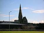 | |||
| West Road, Former Relief United Presbyterian Church | 55°36′53″N 4°40′09″W | Category B | 35411 | | |||
| 4 Glasgow Vennel, Burn's Lodging House | 55°36′51″N 4°39′47″W | Category B | 35415 | | |||
| 18, 20 And 22 (Even Nos) Burns Street | 55°37′06″N 4°40′09″W | Category C(S) | 44648 | | |||
| Castle Street, 25-29 (Inclusive Nos) Academy Court | 55°37′03″N 4°40′11″W | Category B | 44653 | | |||
| 65 High Street | 55°36′51″N 4°39′58″W | Category B | 44670 | | |||
| 71, 73 And 75 High Street | 55°36′52″N 4°39′59″W | Category C(S) | 44671 | | |||
| 95 And 97 High Street | 55°36′53″N 4°40′01″W | Category C(S) | 44673 | | |||
| 49 Kirkgate | 55°36′47″N 4°40′01″W | Category C(S) | 44694 | | |||
| 51 And 53 Kirkgate | 55°36′47″N 4°40′01″W | Category B | 44695 | | |||
| 30 Kirkgate And 1 Hill Street, Old Manse | 55°36′48″N 4°40′02″W | Category B | 35431 | | |||
| 7 Hill Street | 55°36′50″N 4°40′04″W | Category C(S) | 35433 | | |||
| 10 And 12 Harbour Street | 55°36′35″N 4°40′46″W | Category B | 35444 | | |||
| 14 Harbour Street | 55°36′35″N 4°40′47″W | Category B | 35445 | | |||
| 174 Harbour Street, Harbour Master's Office, Including Boundary Walls And Outbuildings | 55°36′27″N 4°41′21″W | Category C(S) | 35448 | | |||
| 25 Bank Street, Templars Hall | 55°36′57″N 4°39′55″W | Category C(S) | 44638 | | |||
| 2, 4 And 6 Bank Street And 108 High Street | 55°36′53″N 4°39′59″W | Category C(S) | 44642 | | |||
| 24-30 (Even Nos) Burns Street | 55°37′07″N 4°40′09″W | Category C(S) | 44649 | | |||
| 32 And 34 Eglinton Street, Turf Hotel | 55°37′04″N 4°40′07″W | Category C(S) | 44661 | | |||
| 157 High Street | 55°36′56″N 4°40′06″W | Category C(S) | 44681 | | |||
| 26 And 28 Hill Street | 55°36′51″N 4°40′04″W | Category C(S) | 44691 | | |||
| 43 Kirkgate | 55°36′46″N 4°40′00″W | Category B | 44692 | | |||
| 26 Kirkgate Including Boundary Walls | 55°36′49″N 4°40′00″W | Category C(S) | 44698 | | |||
| 3 Kilwinning Road, Laurelbank, Including Boundary Walls And Gatepiers | 55°37′07″N 4°40′13″W | Category C(S) | 44699 | | |||
| 14 Kilwinning Road, Campbellfield, Including Boundary Walls And Gatepiers | 55°37′19″N 4°40′13″W | Category B | 44702 | | |||
| New Street, Railway Station | 55°36′40″N 4°40′28″W | Category C(S) | 44705 | | |||
| 24 Seagate With Gatepiers | 55°37′01″N 4°40′15″W | Category C(S) | 44708 | | |||
| 47 And 49 Townhead | 55°36′49″N 4°39′47″W | Category B | 44710 | | |||
| Seagate, Seagate Castle | 55°37′01″N 4°40′14″W | Category A | 35421 | | |||
| 113 And 115 High Street, King's Arms Hotel | 55°36′54″N 4°40′04″W | Category C(S) | 35424 | | |||
| 3 And 5 Hill Street | 55°36′49″N 4°40′03″W | Category C(S) | 35432 | | |||
| 8 Harbour Street | 55°36′35″N 4°40′45″W | Category B | 35443 | | |||
| Harbour Pilot House | 55°36′20″N 4°41′39″W | Category B | 35449 | | |||
| Stanecastle Gates | 55°37′31″N 4°38′33″W | Category B | 7646 | | |||
| 56 Harbour Street | 55°36′31″N 4°40′54″W | Category C(S) | 44665 | | |||
| 18 Annick Road | 55°36′48″N 4°39′30″W | Category C(S) | 44631 | | |||
| 1, 3 Bank Street And 110 High Street | 55°36′54″N 4°40′01″W | Category B | 44634 | | |||
| 9, 11 And 13 Bank Street | 55°36′54″N 4°40′00″W | Category C(S) | 44636 | | |||
| Harbour Street, Marina Inn, Including Outbuildings And Boundary Walls | 55°36′28″N 4°41′09″W | Category C(S) | 44667 | | |||
| 127 And 129 High Street | 55°36′55″N 4°40′04″W | Category C(S) | 44675 | | |||
| 145, 147 And 149 High Street | 55°36′56″N 4°40′05″W | Category B | 44678 | | |||
| 82-106 (Even Nos) High Street | 55°36′53″N 4°39′59″W | Category C(S) | 44682 | | |||
| 20 Hill Street | 55°36′50″N 4°40′03″W | Category C(S) | 44690 | | |||
| 4 Kilwinning Road, Including Boundary Walls And Gatepiers | 55°37′14″N 4°40′11″W | Category B | 44700 | | |||
| 23 Quarry Road Including Boundary Walls | 55°37′09″N 4°40′02″W | Category C(S) | 44706 | | |||
| 17 Hill Street | 55°36′51″N 4°40′05″W | Category C(S) | 35435 | | |||
| Harbour Street, Scottish Maritime Museum, Sv Carrick | 55°36′43″N 4°40′45″W | Category A | 35451 | | |||
| Ayrshire Central Hospital, Administration Building, Maternity Residences And Gatelodge | 55°38′05″N 4°40′23″W | Category B | 35452 | | |||
| High Street, Court House With Lamp Standards | 55°36′53″N 4°39′56″W | Category B | 35414 | | |||
| Academy Road, Old Irvine Academy, Including Outbuildings, Boundary Walls And Gatepiers | 55°37′06″N 4°40′17″W | Category B | 35417 | | |||
| Lawthorn Farmhouse And Attached Farm Buildings, Lawthorn | 55°37′59″N 4°37′34″W | Category B | 7647 | | |||
| Lawthorn Bank, Perceton | 55°37′53″N 4°37′20″W | Category C(S) | 7648 | | |||
| 21 And 23 Bank Street | 55°36′56″N 4°39′56″W | Category C(S) | 44637 | | |||
| 57 Bank Street | 55°37′00″N 4°39′46″W | Category C(S) | 44639 | | |||
| 20 Bank Street | 55°36′54″N 4°39′56″W | Category B | 44643 | | |||
| 60 Bank Street | 55°36′59″N 4°39′45″W | Category B | 44644 | | |||
| 1 And 3 Bridgegate | 55°36′53″N 4°40′01″W | Category B | 44645 | | |||
| 40 Harbour Street | 55°36′33″N 4°40′51″W | Category C(S) | 44662 | | |||
| 156 And 158 High Street | 55°36′57″N 4°40′03″W | Category C(S) | 44686 | | |||
| 162 High Street, The Crown Inn | 55°36′58″N 4°40′04″W | Category C(S) | 44687 | | |||
| 45 And 47 Kirkgate | 55°36′47″N 4°40′01″W | Category B | 44693 | | |||
| 57 Kirkgate | 55°36′47″N 4°40′02″W | Category C(S) | 44697 | | |||
| 17 West Road Including Boundary Walls And Outbuildings | 55°36′56″N 4°40′15″W | Category C(S) | 44713 | | |||
| Gottries Road, Linthouse Building, Scottish Maritime Museum | 55°36′40″N 4°40′45″W | Category A | 35450 | 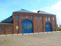 | |||
| West Road, Mure Church (Church Of Scotland), With Adjoining Hall, Gatepiers, Gates, Boundary Walls And Railings | 55°36′54″N 4°40′12″W | Category B | 35412 | | |||
| Girdle Cottage, Girdle Toll | 55°37′45″N 4°38′14″W | Category C(S) | 13664 | |
Key
The scheme for classifying buildings in Scotland is:
- Category A: "buildings of national or international importance, either architectural or historic; or fine, little-altered examples of some particular period, style or building type."[1]
- Category B: "buildings of regional or more than local importance; or major examples of some particular period, style or building type, which may have been altered."[1]
- Category C: "buildings of local importance; lesser examples of any period, style, or building type, as originally constructed or moderately altered; and simple traditional buildings which group well with other listed buildings."[1]
In March 2016 there were 47,288 listed buildings in Scotland. Of these, 8 per cent were Category A, and 50 per cent were Category B, with the rest listed at Category C.[2]
Notes
- Sometimes known as OSGB36, the grid reference (where provided) is based on the British national grid reference system used by the Ordnance Survey.
• "Guide to National Grid". Ordnance Survey. Retrieved 12 December 2007.
• "Get-a-map". Ordnance Survey. Retrieved 17 December 2007. - Historic Environment Scotland assign a unique alphanumeric identifier to each designated site in Scotland, for listed buildings this always begins with "LB", for example "LB12345".
References
- All entries, addresses and coordinates are based on data from Historic Scotland. This data falls under the Open Government Licence
- "What is Listing?". Historic Environment Scotland. Retrieved 29 May 2018.
- Scotland's Historic Environment Audit 2016 (PDF). Historic Environment Scotland and the Built Environment Forum Scotland. pp. 15–16. Retrieved 29 May 2018.
This article is issued from Wikipedia. The text is licensed under Creative Commons - Attribution - Sharealike. Additional terms may apply for the media files.