List of listed buildings in Edinburgh/6
List
| Name | Location | Date Listed | Grid Ref. [note 1] | Geo-coordinates | Notes | LB Number [note 2] | Image |
|---|---|---|---|---|---|---|---|
| 112-112A And 114 Newhaven Road With Front Wall And Railings; Eh6 4Br | 55°58′24″N 3°11′18″W | Category B | 27195 |  | |||
| 116 And 118 (Gf And 1F) Newhaven Road With Front Wall; Eh6 4Br | 55°58′25″N 3°11′18″W | Category C(S) | 27204 | | |||
| 4-10 (Even Nos) Pittville Street | 55°57′07″N 3°06′21″W | Category B | 27206 | | |||
| 1 Newmills Road, (Newmills House) And 3 Newmills Road, (Currie Riggs) With Garden Wall, Bee-Boles, Topiary Hedge, Stables And Boundary Wall And Gatepiers | 55°53′24″N 3°19′57″W | Category B | 27208 | | |||
| 79, 81 And 81A Colinton Road | 55°55′49″N 3°13′17″W | Category C(S) | 27211 | | |||
| 5A, 5B And 5C Kirkgate, Liberton Parish Church With Memorials, Session House, Graveyard, Gates And Gatepiers, Walls And Railings | 55°54′48″N 3°09′39″W | Category A | 27090 | 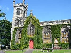 | |||
| Glasgow Road, Castle Gogar With Cottage, Gate House, Stables, Outbuildings, Gate And Gatepiers | 55°56′32″N 3°20′20″W | Category A | 27092 | | |||
| 1 Gillsland Road Tornaveen House | 55°55′55″N 3°13′18″W | Category B | 27094 | | |||
| Lymphoy House With Urn, Garden Seats, Sundial, Gatepiers And Boundary Wall | 55°53′21″N 3°19′23″W | Category B | 27096 | | |||
| 16 And 17 Cluny Avenue | 55°55′33″N 3°12′11″W | Category B | 27099 | | |||
| 88 Lothian Road, Filmhouse Including Boundary Walls And Gatepiers | 55°56′47″N 3°12′22″W | Category B | 27100 | | |||
| 4 Main Street Royal Bank Of Scotland With Boundary Wall | 55°53′04″N 3°20′24″W | Category C(S) | 27115 | | |||
| 31-39 (Odd Nos) Madeira Street With Front And Garden Walls, Steps And Railings; Eh6 4Aj | 55°58′32″N 3°10′56″W | Category C(S) | 27120 | | |||
| Glasgow Road Gogarburn Hospital Gogarburn House | 55°56′03″N 3°20′21″W | Category B | 27121 | | |||
| 59 And 61 Morton Street | 55°56′50″N 3°05′55″W | Category C(S) | 27122 | | |||
| 37 And 39 Cluny Gardens | 55°55′30″N 3°12′10″W | Category C(S) | 27127 | | |||
| 24 And 26 Main Street, Balerno Hardware And Pharmacy | 55°53′02″N 3°20′21″W | Category C(S) | 27131 | | |||
| 34 And 36 Brighton Place | 55°57′06″N 3°07′01″W | Category B | 27132 | | |||
| 28-32 (Even Nos) Main Street | 55°53′02″N 3°20′20″W | Category C(S) | 27138 | | |||
| 42 And 44 Brighton Place | 55°57′04″N 3°07′03″W | Category B | 27146 | | |||
| 25 Spylaw Road, Elmpark With Boundary Wall And Gatepiers | 55°55′57″N 3°13′04″W | Category C(S) | 27023 | | |||
| 527, Lanark Road West, Ravelrig Estate, Gatepiers And Boundary Wall | 55°53′17″N 3°20′42″W | Category B | 27025 | | |||
| Greyfriars Place, Greyfriars Churchyard, Including Monuments, Lodge Gatepiers, Railings And Walls | 55°56′45″N 3°11′32″W | Category A | 27029 | 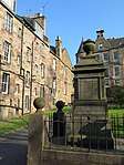 | |||
| 5 And 7 Joppa Road Including Boundary Walls | 55°56′57″N 3°06′06″W | Category B | 27032 | | |||
| 87, 89 Restalrig Road With Gatepiers, Boundary Walls And Lamp Standard | 55°58′02″N 3°09′25″W | Category C(S) | 27034 | | |||
| 13 And 15 Church Hill With Stable Block, Boundary Walls And_Gatepiers | 55°55′58″N 3°12′21″W | Category B | 27038 | | |||
| 29 Joppa Road (Hawthorn Cottage) Including Gateway And Boundary Walls | 55°56′56″N 3°06′00″W | Category B | 27052 | | |||
| 11 Ettrick Road | 55°56′04″N 3°13′15″W | Category B | 27053 |  | |||
| 4-8 (Inclusive Nos) Church Hill Drive | 55°55′56″N 3°12′27″W | Category C(S) | 27058 | | |||
| 2 Ettrick Road Kilmeny With Garage Gardener's Cottage Boundary Wall Gatepiers Gates And Railings | 55°55′59″N 3°13′13″W | Category C(S) | 27064 | | |||
| 3 Seafield Avenue, Seafield Cemetery Gate Lodge With Pavilion, Boundary Wall, Gatepiers And Railings | 55°58′14″N 3°09′05″W | Category B | 27065 | | |||
| 6 And 8 Brighton Place | 55°57′10″N 3°06′54″W | Category B | 27067 | | |||
| 9 And 11 Infirmary Street | 55°56′54″N 3°11′08″W | Category B | 27080 | | |||
| Leith Docks, Victoria Dock And Lock Gates | 55°58′45″N 3°10′24″W | Category B | 27081 | | |||
| Foxhall Stables And Cottages | 55°57′08″N 3°23′37″W | Category C(S) | 27082 | | |||
| 6, 8 Seafield Road With Railings | 55°58′16″N 3°09′04″W | Category B | 27085 | | |||
| Lymphoy Estate, Lennox Tower | 55°53′25″N 3°19′22″W | Category B | 27086 | | |||
| 14 And 16 Brighton Place | 55°57′09″N 3°06′56″W | Category B | 27087 | | |||
| 20-26 (Even Nos) Bernard Street | 55°58′34″N 3°10′03″W | Category B | 26935 | | |||
| 42 Canaan Lane | 55°55′41″N 3°12′18″W | Category C(S) | 26936 | | |||
| 28 Bernard Street And 47, 47A Timber Bush | 55°58′34″N 3°10′04″W | Category B | 26947 | | |||
| Mcleod Street, Tynecastle High School With Workshops, Gates, Gatepiers And Railings | 55°56′27″N 3°13′57″W | Category B | 26950 | 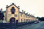 | |||
| 9-17 (Odd Nos) Pirniefield Place With Boundary Wall | 55°58′12″N 3°09′06″W | Category C(S) | 26967 | | |||
| 16A Bellfield Street, Portobello Old And Windsor Parish Church (Church Of Scotland), Including Gates, Gatepiers And Boundary Walls | 55°57′08″N 3°06′30″W | Category B | 26969 |  | |||
| 38-42 (Even Nos) Bernard Street | 55°58′34″N 3°10′07″W | Category B | 26971 | | |||
| 67 Restalrig Road With Boundary Wall | 55°58′05″N 3°09′29″W | Category C(S) | 26990 | | |||
| 68-78 (Even Nos) Colinton Road With Railings | 55°55′35″N 3°14′00″W | Category B | 27001 | | |||
| St. Cuthbert's Churchyard, The Dell Colinton | 55°54′34″N 3°15′23″W | Category B | 26875 | | |||
| Carlowrie House With Terrace, Toolshed Tower, Lodge And Gatepiers, Stables And Cottage, Garden Walls And Walled Garden | 55°57′20″N 3°22′33″W | Category A | 26879 | | |||
| 2-3 Hermitage Place, Merith House Hotel With Boundary Wall | 55°58′09″N 3°09′50″W | Category B | 26882 | | |||
| Harlaw Road, Balleny Bridge | 55°52′29″N 3°19′14″W | Category C(S) | 26883 | | |||
| Kirk Loan And 2A Corstorphine High Street, Corstorphine Old Parish Church And Churchyard Including Boundary Walls, Vault And Gate House, Gatepiers, Gates And War Memorial | 55°56′29″N 3°16′55″W | Category A | 26888 | | |||
| Clifton Hall With Stables, Outbuildings, Dovecot And Clifton Beag | 55°55′23″N 3°25′35″W | Category A | 26891 | | |||
| 22 Colinton Road With Boundary Walls Gatepiers And Railings | 55°55′54″N 3°13′07″W | Category C(S) | 26893 | | |||
| 4 Bernard Street | 55°58′32″N 3°10′01″W | Category B | 26898 | | |||
| 6-13 (Inclusive Nos) Hermitage Place With Boundary Walls | 55°58′09″N 3°09′54″W | Category B | 26906 | | |||
| 6-10 (Even Nos) Bernard Street | 55°58′33″N 3°10′01″W | Category B | 26910 | | |||
| 18 Cramond Glebe Road, Cramond Parish Church (Church Of Scotland) Including Graveyard, Gatehouse, Gatepiers, Gates And Boundary Wall | 55°58′40″N 3°18′00″W | Category A | 26912 | | |||
| Johnsburn Road, Johnsburn House With Stables, Bridge And Gatepiers | 55°52′49″N 3°21′02″W | Category B | 26919 | | |||
| 40 Canaan Lane With Boundary Wall | 55°55′40″N 3°12′20″W | Category C(S) | 26923 | | |||
| Duddingston Parish Church (C Of S) Including Churchyard And Watch Tower Old Church Lane Duddingston | 55°56′28″N 3°08′56″W | Category A | 26924 | | |||
| Haymarket Terrace, Ryrie's (Formerly Haymarket Inn) | 55°56′45″N 3°13′02″W | Category B | 26926 |  | |||
| 89-93 (Odd Nos) Ferry Road With 89A And 93A And Boundary Walls, Steps And Railings; Eh6 4Aq | 55°58′29″N 3°10′59″W | Category C(S) | 26927 | | |||
| Commercial Street And Dock Street, Former Mariner's Church | 55°58′37″N 3°10′29″W | Category C(S) | 26800 | | |||
| 137-155 Odd Nos Colinton Road | 55°55′33″N 3°14′00″W | Category C(S) | 26803 | | |||
| Distillery Lane And Dalry Road, Caledonian Distillery | 55°56′40″N 3°13′13″W | Category B | 26811 | | |||
| 1-4 (Inclusive Nos) Elcho Terrace | 55°57′06″N 3°06′21″W | Category B | 26827 | | |||
| Glenbrook Road, House Of Cockburn (Formerly Westbrook) With Boundary Wall, Gates And Gatepiers | 55°52′38″N 3°22′08″W | Category B | 26830 | | |||
| 33 Bernard Street | 55°58′33″N 3°10′06″W | Category B | 26834 | | |||
| 102 Commercial Street, Bonds 46, 48 And 35 (Highland And Queen, West Warehouses) With Gatepiers | 55°58′39″N 3°10′31″W | Category A | 26838 | | |||
| Bonnington Dovecot | 55°54′26″N 3°25′22″W | Category A | 26839 | | |||
| 4-12 (Inclusive Nos) Gladstone Place With Boundary Wall | 55°58′11″N 3°09′34″W | Category C(S) | 26842 | | |||
| 7 Lorne Street, Lorne Primary School, With Janitor's House, Outbuilding, Shelter And Gatepiers | 55°57′57″N 3°10′29″W | Category B | 26845 | | |||
| Dalry Place, The Dalry Terrs; Dalry Rd 15-29 & 31-47 Walker Terr 9-16 Lewis Terr 9-16 Cobden Terr 1-16 Douglas Terr 1-16 Bright Terr 1-16, Argyll Terr 1-16 Mclaren Terr 1-10 Atholl Terr 1-16, Breadalbane Terr 1-18 With Railgs & Grdn Walls | 55°56′42″N 3°13′03″W | Category B | 26746 | | |||
| 50 Coburg Street And 9 (Flats 1-26) And 12 Couper Street | 55°58′34″N 3°10′37″W | Category B | 26747 | | |||
| 13 Bangor Road, Salvation Army Hall | 55°58′23″N 3°10′38″W | Category C(S) | 26756 | | |||
| 2-18 Inclusive Nos Shandon Crescent 1-5 Odd Nos Shandon Road And 29 Shandon Street With Boundary Walls | 55°56′01″N 3°13′56″W | Category C(S) | 26768 | | |||
| 68-70 (Even Nos) Leamington Terrace, Bruntsfield Evangelical Church And Hall Including Boundary Walls, Gatepiers, Gates And Railings | 55°56′17″N 3°12′26″W | Category B | 26772 |  | |||
| 10, 11 Claremont Park With Boundary Wall And Gatepiers | 55°58′11″N 3°09′17″W | Category B | 26778 | | |||
| 9 And 11 Braid Road | 55°55′26″N 3°12′32″W | Category B | 26784 | | |||
| 1-4 (Inclusive Nos) Bath Place | 55°57′18″N 3°06′42″W | Category B | 26702 | | |||
| Ardmillan Terrace North Merchiston Cemetery With Lodge Gates And Boundary Walls | 55°56′15″N 3°13′36″W | Category C(S) | 26704 | | |||
| 1-12 (Inclusive Nos And 6A/B) Bonnington Terrace With Boundary Walls And Railings; Eh6 4Bp | 55°58′23″N 3°11′19″W | Category B | 26709 | | |||
| 4-26 Even Nos Blantyre Terrace 2 Merchiston Avenue And 1 Mardale Crescent | 55°56′03″N 3°12′45″W | Category C(S) | 26712 | | |||
| 24 Dalmeny Street, And Buchanan Street, Ukrainian Catholic Church Of St Andrew | 55°57′53″N 3°10′29″W | Category B | 26716 | | |||
| 1 Wright's Houses, Barclay-Bruntsfield Church And Church Hall (Church Of Scotland) | 55°56′25″N 3°12′12″W | Category A | 26720 | _Church_01.JPG) | |||
| 13 Bonnington Terrace And 203 Ferry Road, (1F And 2F) Bonnington Mount, With Boundary Walls And Gatepiers; Eh6 4Bp And Eh6 4Nn Respectively | 55°58′25″N 3°11′22″W | Category B | 26722 | | |||
| 4-20 Bruntsfield Avenue | 55°56′11″N 3°12′32″W | Category C(S) | 26725 | | |||
| 1-9 (Inclusive Nos) Albert Terrace | 55°55′52″N 3°12′41″W | Category B | 26732 | | |||
| Coburg Street, North Leith Burial Ground | 55°58′33″N 3°10′31″W | Category B | 26735 | | |||
| 158-174 Even Nos Bruntsfield Place And 2 Bruntsfield Avenue | 55°56′11″N 3°12′32″W | Category B | 26738 | | |||
| 45 Bavelaw Road, Balerno Bank Paper Mill Offices | 55°52′58″N 3°20′19″W | Category B | 26740 | | |||
| 3-17 Odd Nos Blantyre Terrace 6 Rochester Terrace And 4 Merchiston Avenue | 55°56′04″N 3°12′45″W | Category C(S) | 26699 | | |||
| Old Dalkeith Road Summerside Farmhouse, Stables And Cottage Range | 55°54′03″N 3°05′43″W | Category B | 14186 | | |||
| Baberton House, Including Gates, Gatepiers And Boundary Walls | 55°54′33″N 3°17′45″W | Category A | 6129 | | |||
| Dalmeny Village, 1 And 2 Easter Dalmeny | 55°58′57″N 3°22′21″W | Category C(S) | 5528 | | |||
| Dalmeny Village, 1 And 2 Main Street | 55°58′56″N 3°22′19″W | Category C(S) | 5532 | | |||
| Dalmeny Village, 5 Main Street | 55°58′55″N 3°22′22″W | Category B | 5534 | | |||
| Bankhead, Bankhead Farmhouse, Including Gatepiers And Boundary Wall | 55°59′19″N 3°22′39″W | Category C(S) | 5551 | | |||
| Craigiehall, Sundials | 55°57′52″N 3°20′15″W | Category A | 5559 | | |||
| Craigiehall, Dovecot | 55°57′54″N 3°20′16″W | Category B | 5560 | | |||
| Dalmeny House, Laundry At Dalmeny Home Farm | 55°58′48″N 3°19′57″W | Category C(S) | 5500 | | |||
| Dundas Castle, Walled Garden | 55°58′21″N 3°25′13″W | Category B | 5515 | | |||
| Lowood, Including Outbuildings, Boundary Walls And Gatepiers | 55°58′19″N 3°19′54″W | Category B | 5519 | | |||
| 12-16 (Inclusive Nos) Bank Street | 55°56′59″N 3°11′35″W | Category B | 3006 | .jpg) | |||
| Dalmeny Village, 4 Wester Dalmeny | 55°58′57″N 3°22′25″W | Category C(S) | 81 | | |||
| 4 Marine Drive And 11 West Shore Road, Granton Gasworks, Entrance Gateway And Gatehouse On West Granton Road | 55°58′36″N 3°14′45″W | Category C(S) | 45792 | | |||
| 4 Marine Drive And 11 West Shore Road, Granton Gasworks, Former Station/Office, Including Railway Platform | 55°58′42″N 3°14′29″W | Category B | 45794 | | |||
| 46 Frogston Road West, Including Garage, Boundary Wall And Terrace With Planters | 55°53′56″N 3°11′44″W | Category C(S) | 45839 | | |||
| 13 And 14 Swanston Village | 55°53′33″N 3°13′01″W | Category B | 45848 | | |||
| 25 Winton Loan | 55°53′47″N 3°11′41″W | Category C(S) | 45851 | | |||
| 27-31 (Odd Nos) Winton Loan | 55°53′47″N 3°11′41″W | Category C(S) | 45852 | | |||
| 4 And 5 Bonnyhaugh Lane | 55°58′16″N 3°11′18″W | Category C(S) | 45923 | | |||
| 21-25 (Odd Nos) Broughton Place | 55°57′31″N 3°11′16″W | Category B | 45926 | | |||
| 14-18 (Even Nos) Broughton Place | 55°57′32″N 3°11′20″W | Category A | 45928 | | |||
| 20-28 (Even Nos) Broughton Place | 55°57′32″N 3°11′19″W | Category A | 45929 | | |||
| 30-34 (Even Nos) Broughton Place | 55°57′33″N 3°11′17″W | Category A | 45930 | | |||
| 93-101 (Odd Nos) Broughton Street And 2 Broughton Place | 55°57′31″N 3°11′23″W | Category B | 45932 | | |||
| 51-77 (Odd Nos) East Claremont Street | 55°57′44″N 3°11′32″W | Category A | 45940 | | |||
| 1-9 (Odd Nos) East London Street | 55°57′33″N 3°11′25″W | Category B | 45942 | | |||
| 5 And 5A Forth Street | 55°57′27″N 3°11′16″W | Category B | 45945 | | |||
| 19-27 (Odd Nos) Forth Street | 55°57′28″N 3°11′13″W | Category B | 45948 | | |||
| 14 And 16 Forth Street | 55°57′29″N 3°11′15″W | Category B | 45950 | | |||
| 26 Forth Street | 55°57′29″N 3°11′12″W | Category B | 45954 | | |||
| 28 And 30 Forth Street | 55°57′29″N 3°11′11″W | Category B | 45955 | | |||
| Mcdonald Road, Bridgeside Works Including Boundary Walls And Gatepiers | 55°57′54″N 3°11′11″W | Category C(S) | 45958 | | |||
| 30 And 32 Pilrig Street And Boundary Walls | 55°57′52″N 3°10′46″W | Category C(S) | 45959 | | |||
| 94 Pilrig Street And Boundary Walls And Railings | 55°58′00″N 3°10′56″W | Category B | 45960 | | |||
| 1-28 (Inclusive Nos) Shaw's Street, 1-10 (Inclusive Nos) Shaw's Place And 1-18 (Inclusive Nos) Shaw's Terrace | 55°57′50″N 3°10′53″W | Category B | 45961 | | |||
| 45-57A (Odd Nos) Albany Street, Including Railings | 55°57′27″N 3°11′21″W | Category A | 46114 | | |||
| 9-31B (Odd Nos) Barony Street, And 1 And 2 Albany Lane, Including Wall And Letter Box | 55°57′29″N 3°11′27″W | Category C(S) | 46115 | | |||
| 1-3 (Odd Nos) Cornwallis Place, Including Railings | 55°57′40″N 3°11′41″W | Category C(S) | 46118 | | |||
| Great Stuart Street, Lamp Standard | 55°57′10″N 3°12′38″W | Category B | 46119 | | |||
| Moray Place Bank Gardens, Railings And Gates | 55°57′17″N 3°12′31″W | Category A | 46120 | | |||
| 2-16 (Even Nos) Cluny Place | 55°55′35″N 3°12′05″W | Category B | 46294 | | |||
| 8-30 (Even Nos) Morningside Park | 55°55′41″N 3°12′39″W | Category B | 46295 | | |||
| 237 Morningside Road, The Canny Man's | 55°55′39″N 3°12′33″W | Category B | 46297 | | |||
| 1-31 (Inclusive Nos) Earl Haig Gardens | 55°58′29″N 3°12′16″W | Category C(S) | 46726 | | |||
| Ferry Road, Bridge Over Former Railway | 55°58′19″N 3°12′06″W | Category B | 46730 | | |||
| 29 Primrose Bank Road, Wardie Parish Church And Hall (Church Of Scotland) | 55°58′43″N 3°12′39″W | Category B | 46741 | | |||
| 36-42 (Even Nos) Primrose Bank Road, With Boundary Walls And Gatepiers | 55°58′46″N 3°12′37″W | Category B | 46745 | | |||
| 120-134 (Even Nos) Trinity Road, With Boundary Wall | 55°58′44″N 3°12′22″W | Category C(S) | 46753 | | |||
| 45 Ratcliffe Terrace, Leslie's Bar | 55°56′02″N 3°10′41″W | Category B | 46775 | 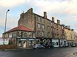 | |||
| 1-3 (Inclusive Nos) Lauriston Terrace Including Access Terrace And Railings | 55°56′41″N 3°11′42″W | Category B | 47045 |  | |||
| Tollcross, Clock | 55°56′37″N 3°12′13″W | Category C(S) | 47048 | | |||
| Dreghorn Loan, Laverock Dale Cottage | 55°54′09″N 3°15′00″W | Category C(S) | 47283 | | |||
| 3 Bristo Place, Seventh Day Adventist Church | 55°56′47″N 3°11′24″W | Category B | 47341 | .jpg) | |||
| 21 St John Street, Chancery Of The Order Of St John In Scotland, Including Boundary Wall, Gates And Railings | 55°57′02″N 3°10′53″W | Category C(S) | 47586 | | |||
| 89-93 (Odd Nos) Marchmont Road | 55°56′09″N 3°11′38″W | Category B | 47603 |  | |||
| Crawfurd Road, Former Club House | 55°55′52″N 3°10′02″W | Category C(S) | 47605 | |
Key
The scheme for classifying buildings in Scotland is:
- Category A: "buildings of national or international importance, either architectural or historic; or fine, little-altered examples of some particular period, style or building type."[1]
- Category B: "buildings of regional or more than local importance; or major examples of some particular period, style or building type, which may have been altered."[1]
- Category C: "buildings of local importance; lesser examples of any period, style, or building type, as originally constructed or moderately altered; and simple traditional buildings which group well with other listed buildings."[1]
In March 2016 there were 47,288 listed buildings in Scotland. Of these, 8 per cent were Category A, and 50 per cent were Category B, with the rest listed at Category C.[2]
Notes
- Sometimes known as OSGB36, the grid reference (where provided) is based on the British national grid reference system used by the Ordnance Survey.
• "Guide to National Grid". Ordnance Survey. Retrieved 12 December 2007.
• "Get-a-map". Ordnance Survey. Retrieved 17 December 2007. - Historic Environment Scotland assign a unique alphanumeric identifier to each designated site in Scotland, for listed buildings this always begins with "LB", for example "LB12345".
References
- All entries, addresses and coordinates are based on data from Historic Scotland. This data falls under the Open Government Licence
- "What is Listing?". Historic Environment Scotland. Retrieved 29 May 2018.
- Scotland's Historic Environment Audit 2016 (PDF). Historic Environment Scotland and the Built Environment Forum Scotland. pp. 15–16. Retrieved 29 May 2018.
This article is issued from Wikipedia. The text is licensed under Creative Commons - Attribution - Sharealike. Additional terms may apply for the media files.