List of listed buildings in Edinburgh/24
List
| Name | Location | Date Listed | Grid Ref. [note 1] | Geo-coordinates | Notes | LB Number [note 2] | Image |
|---|---|---|---|---|---|---|---|
| 15-18 Teviot Place | 55°56′44″N 3°11′26″W | Category C(S) | 48251 |  | |||
| 57 Dreghorn Loan, Dunalistair House Lodge | 55°54′13″N 3°15′05″W | Category C(S) | 48535 | | |||
| 42 Murrayfield Road, Glion And Crossways | 55°56′59″N 3°14′58″W | Category C(S) | 48901 | | |||
| Ravelston Dykes Road, Mary Erskine School (Former Ravelston House), Ice House | 55°57′12″N 3°15′18″W | Category C(S) | 48903 | | |||
| 87 Ravelston Dykes Road, Wall Incorporating Old Fireplace (1 Of 2) And Ice House Entrance | 55°57′07″N 3°15′19″W | Category B | 48907 | | |||
| Roseburn Terrace, Roseburn New Bridge | 55°56′45″N 3°14′10″W | Category C(S) | 48913 | | |||
| 1 Roseburn Terrace And Roseburn Street, Roseburn Bar, The Flyhalf | 55°56′43″N 3°14′02″W | Category C(S) | 48914 | | |||
| 9 Succoth Gardens | 55°57′01″N 3°14′18″W | Category B | 48915 | | |||
| 5-8 (Inclusive Numbers) Piershill Place | 55°57′18″N 3°08′52″W | Category B | 49045 | | |||
| 168 Easter Road, St Margaret's Episcopal Church Including School, Boundary Wall And Railings | 55°57′39″N 3°10′16″W | Category C(S) | 49056 | | |||
| 124 And 126 Willowbrae Road With Boundary Wall, Railings And Gates | 55°57′08″N 3°08′43″W | Category C(S) | 49062 | | |||
| St Giles Street, K6 Telephone Kiosk | 55°57′01″N 3°11′32″W | Category B | 49068 | .jpg) | |||
| 11-17 (Odd Nos) Annandale Street Including Railings | 55°57′35″N 3°11′03″W | Category A | 49144 | | |||
| 11 And 13 Union Street Including Railings And Boundary Wall | 55°57′29″N 3°11′09″W | Category B | 49152 | | |||
| Holyrood Park, Duddingston (South) Lodge, 32, Old Church Lane | 55°56′31″N 3°09′00″W | Category B | 49511 | | |||
| 1 Craigend Park, Kingston Lodge With Boundary Wall And Gatepiers | 55°55′05″N 3°09′13″W | Category C(S) | 49540 | | |||
| 11 Kinnear Road, Scott House And Boundary Wall | 55°58′04″N 3°13′03″W | Category B | 49542 | | |||
| 25 Bridge Road, Railings And Gates | 55°54′26″N 3°15′33″W | Category A | 49552 | | |||
| 2A Thorburn Road, Bonaly Primary School Annex With Outbuildings And Boundary Wall | 55°54′27″N 3°15′09″W | Category C(S) | 49572 | | |||
| Fettes College, Sundial | 55°57′50″N 3°13′39″W | Category A | 49628 | | |||
| 7 Regent Terrace Including Railings And Boundary Walls | 55°57′16″N 3°10′39″W | Category A | 49770 | | |||
| 14 Regent Terrace, Including Railings And Boundary Walls | 55°57′17″N 3°10′36″W | Category A | 49777 |  | |||
| 19 Regent Terrace Including Railings And Boundary Walls | 55°57′18″N 3°10′34″W | Category A | 49782 |  | |||
| 22 Regent Terrace Including Railings And Boundary Walls | 55°57′19″N 3°10′33″W | Category A | 49785 | 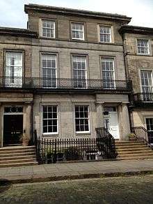 | |||
| 69-74 (Inclusive Nos) Bruntsfield Place, Bruntsfield Hotel With Boundary Wall | 55°56′17″N 3°12′21″W | Category C(S) | 49834 | | |||
| 11 Succoth Avenue | 55°56′59″N 3°14′23″W | Category B | 49837 | | |||
| Chalmer's Close, (Between High Street And Jeffrey Street), Trinity College Church Apse, Including Carved Stone Fragments And Boundary Walls | 55°57′04″N 3°11′08″W | Category A | 25747 | | |||
| 30 George Square, University Of Edinburgh, Main Library | 55°56′34″N 3°11′20″W | Category A | 50191 |  | |||
| 48A The Pleasance, University Of Edinburgh, Examination Hall, (Former Free Church) | 55°56′52″N 3°10′55″W | Category C(S) | 50199 | | |||
| 12 Cramond Road North, Avisfield With Garden Walls And Terraces | 55°58′27″N 3°17′24″W | Category B | 50793 | | |||
| 13 Croft-An-Righ, St Anne's Yard (Former Brewery Buildings) | 55°57′17″N 3°10′17″W | Category B | 51175 | 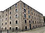 | |||
| 78 And 78A Inverleith Place | 55°57′56″N 3°13′08″W | Category C(S) | 51317 | | |||
| 94 Inverleith Place | 55°57′54″N 3°13′16″W | Category C(S) | 51318 | | |||
| 3 Miller Row, Riverside Works, (Former Squash Court) | 55°57′10″N 3°12′53″W | Category B | 51339 | | |||
| 25 Palmerston Place | 55°56′58″N 3°13′05″W | Category B | 51340 | | |||
| 83/85 Boswall Parkway, St Margaret Mary's Roman Catholic Church | 55°58′33″N 3°13′57″W | Category B | 45647 | | |||
| Granton Harbour, Sea Wall And Embankment To East Of Mid Pier | 55°59′10″N 3°13′26″W | Category C(S) | 45651 | | |||
| 159 Lower Granton Road, Former Stables, Including Gatepiers And Boundary Wall | 55°58′50″N 3°13′23″W | Category B | 45656 | | |||
| Dundas Castle, Boat House | 55°58′09″N 3°24′50″W | Category B | 45471 | | |||
| Baberton House, Bothy | 55°54′33″N 3°17′48″W | Category C(S) | 45414 | | |||
| Dalmeny House, Gardener's Cottage, Including Boundary Wall | 55°59′15″N 3°20′30″W | Category C(S) | 45437 | | |||
| 7 Gillespie Street, The City Of Edinburgh Council Darroch Education Centre, Former James Gillespie's High School Annexe, Including Boundary Walls, Gates, Gatepiers And Railings | 55°56′26″N 3°12′26″W | Category C(S) | 44934 | | |||
| 63 Gilmore Place, Gilmore Place Free Presbyterian Church Including Boundary Walls, Gates And Gatepiers | 55°56′28″N 3°12′30″W | Category B | 44938 | | |||
| 42-46 (Even Nos) Leamington Terrace Including Boundary Walls, Gates And Railings | 55°56′21″N 3°12′30″W | Category C(S) | 44941 | | |||
| 134 Corstorphine Road, Edinburgh Zoo (Royal Zoological Society Of Scotland) West Lodge Complex | 55°56′42″N 3°16′18″W | Category C(S) | 44751 | | |||
| 18 And 20 St John's Road Including Boundary Walls | 55°56′33″N 3°16′36″W | Category C(S) | 44755 | | |||
| 49 Marine Drive With Boundary Walls And Courtyard Setts | 55°58′34″N 3°16′18″W | Category B | 44620 | | |||
| 75 Restalrig Road South, Including Boundary Walls And Railings | 55°57′32″N 3°08′59″W | Category C(S) | 44628 | | |||
| 32 Charterhall Road | 55°55′33″N 3°11′21″W | Category B | 44206 | | |||
| 64 Dalkeith Road, Including Pedestrian Gates And Boundary Walls | 55°56′15″N 3°10′20″W | Category C(S) | 44212 | | |||
| 10 And 10A Gordon Terrace, Cademuir, Including Gates, Gatepiers And Boundary Walls | 55°55′25″N 3°10′05″W | Category B | 44219 | | |||
| 8 And 10 Granby Road, Including Boundary Walls | 55°55′40″N 3°10′22″W | Category C(S) | 44222 | | |||
| Mayfield Road And West Mains Road, University Of Edinburgh, King's Buildings, Mechanical Engineering | 55°55′23″N 3°10′19″W | Category B | 44229 | | |||
| 2 2A And 4 Mayfield Terrace, Including Boundary Walls | 55°56′04″N 3°10′24″W | Category C(S) | 44234 | | |||
| 2 Queens Crescent, Including Boundary Walls | 55°56′01″N 3°10′20″W | Category C(S) | 44251 | | |||
| 8 And 10 Grove Street, Including Railings | 55°56′44″N 3°12′47″W | Category B | 44036 | | |||
| 10 Barnton Avenue West, The Shaws, Including Gatepiers | 55°58′03″N 3°18′09″W | Category B | 43931 | | |||
| 37, Cammo Road, Cammo Home Farm Including Boundary Wall And Gatepier | 55°57′37″N 3°19′11″W | Category C(S) | 43935 | | |||
| 85 Craighall Road, Station, Including Bridge | 55°58′35″N 3°11′48″W | Category C(S) | 43689 | | |||
| 24-36 (Even Nos) Craighall Road | 55°58′38″N 3°11′51″W | Category C(S) | 43690 | | |||
| 17-27 (Odd Nos) East Trinity Road Including Boundary Walls And Gatepiers | 55°58′38″N 3°11′55″W | Category B | 43691 | | |||
| 4 And 5 Fishmarket Square | 55°58′50″N 3°11′42″W | Category C(S) | 43694 | | |||
| 5 And 6 Great Michael Close | 55°58′50″N 3°11′37″W | Category C(S) | 43698 | | |||
| 4 And 5 Lamb's Court | 55°58′50″N 3°11′43″W | Category C(S) | 43703 | | |||
| 4 And 6 Newhaven Main Street, Victoria Primary School | 55°58′50″N 3°11′34″W | Category B | 43704 | | |||
| 212 And 214 Newhaven Road, Including Gatepiers And Boundary Walls | 55°58′42″N 3°11′35″W | Category B | 43716 | | |||
| 234 And 236 Newhaven Road | 55°58′44″N 3°11′35″W | Category C(S) | 43718 | | |||
| 11 Pier Place | 55°58′50″N 3°11′49″W | Category C(S) | 43725 | | |||
| London Road And 1A-1 Easter Road, Church Of Scotland Church, Church Hall, Offices And Boundary Walls | 55°57′29″N 3°10′20″W | Category B | 43494 | | |||
| 1A Hill Street | 55°57′13″N 3°12′05″W | Category B | 43295 | | |||
| 7-11 (Odd Nos) Hope Street | 55°57′03″N 3°12′28″W | Category B | 43308 | | |||
| 32 North West Thistle Street Lane | 55°57′15″N 3°12′01″W | Category C(S) | 43309 | | |||
| 34 North West Thistle Street Lane | 55°57′15″N 3°12′01″W | Category C(S) | 43310 | | |||
| 79 And 79A Princes Street | 55°57′08″N 3°11′50″W | Category C(S) | 43321 | | |||
| 121-122 Princes Street | 55°57′04″N 3°12′14″W | Category B | 43327 | | |||
| 34 And 36 Rose Street North Lane | 55°57′11″N 3°11′53″W | Category C(S) | 43344 | | |||
| 17 Thistle Street | 55°57′16″N 3°11′48″W | Category B | 43352 | | |||
| 19 Thistle Street | 55°57′16″N 3°11′48″W | Category C(S) | 43353 | | |||
| Liberton Gardens, Alnwickhill Reservoir With Boundary Walls | 55°54′31″N 3°09′58″W | Category B | 43246 | | |||
| Liberton Gardens, Bank Of Scotland | 55°54′44″N 3°09′49″W | Category C(S) | 43248 | | |||
| Gilmerton, 2 Drum Street, Faith Mission And Bible College With Boundary Wall | 55°54′24″N 3°08′06″W | Category B | 43254 | | |||
| 114 And 116 George Street With Railings And Lamp Standards | 55°57′08″N 3°12′16″W | Category C(S) | 43290 | | |||
| 11-19 (Odd Nos) Hanover Street | 55°57′09″N 3°11′47″W | Category C(S) | 43292 | | |||
| 21-27 (Odd Nos) Hanover Street | 55°57′10″N 3°11′47″W | Category B | 43293 | | |||
| 3 Marchhall Crescent, Marchhall Nursing Home Including Boundary Walls And Gatepiers | 55°56′13″N 3°10′08″W | Category B | 43155 | | |||
| 4 Salisbury Road, Synagogue Chambers Including Gatepiers And Boundary Walls | 55°56′17″N 3°10′30″W | Category B | 43172 | 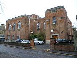 | |||
| 35, 37 And 39 Upper Gray Street, Including Boundary Walls And Pedestrian Gate | 55°56′09″N 3°10′41″W | Category B | 43174 | | |||
| 35 And 35B High Street, Clydesdale Bank | 55°59′24″N 3°23′42″W | Category C(S) | 40382 | | |||
| 36 High Street, The Ferry Tap Ale House, And 1-3 (Inclusive Nos) Forth Court At Rear | 55°59′23″N 3°23′42″W | Category B | 40385 | | |||
| Hopetoun Road, The Priory Church Of St. Mary Of Mount Carmel, Including Boundary Walls | 55°59′27″N 3°23′54″W | Category A | 40391 |  | |||
| 5 Mid Terrace And 1 And 2 Hamilton's Close | 55°59′24″N 3°23′45″W | Category B | 40397 | | |||
| 3 The Vennel, Old Parish Church | 55°59′22″N 3°23′42″W | Category B | 40404 | | |||
| 15 West Terrace | 55°59′24″N 3°23′47″W | Category C(S) | 40408 | | |||
| 17 West Terrace, Rosebery Memorial Hall | 55°59′25″N 3°23′49″W | Category B | 40410 | | |||
| 1 East Terrace | 55°59′23″N 3°23′34″W | Category C(S) | 40337 | | |||
| 2 East Terrace, St. Annes | 55°59′23″N 3°23′35″W | Category B | 40338 | | |||
| 7 Edinburgh Road | 55°59′24″N 3°23′33″W | Category C(S) | 40360 | | |||
| 4 Edinburgh Road To 9 East Terrace, Wall And Railings | 55°59′23″N 3°23′35″W | Category B | 40369 | | |||
| 11-13 (Odd Nos) Spottiswoode Street | 55°56′19″N 3°11′54″W | Category B | 30597 | | |||
| Thirlestane Road Warrender Baths | 55°56′07″N 3°11′51″W | Category B | 30607 | | |||
| 1-2 Warrender Park Crescent & 10-11 Alvanley Terrace Including Walls | 55°56′17″N 3°12′11″W | Category B | 30608 | | |||
| 3-5 (Inclusive Nos) Warrender Park Crescent Incl Railings | 55°56′17″N 3°12′09″W | Category B | 30609 | | |||
| 29-33 (Odd Nos) Warrender Park Road | 55°56′18″N 3°11′39″W | Category B | 30616 |  | |||
| 57-59 (Odd Nos) Warrender Park Road | 55°56′19″N 3°11′47″W | Category B | 30622 | | |||
| 97-101 (Odd Nos) Warrender Park Road | 55°56′18″N 3°11′56″W | Category B | 30630 | | |||
| 147-151 (Odd Nos) Warrender Park Road | 55°56′15″N 3°12′08″W | Category B | 30640 | | |||
| 5-7 (Incl Nos) Warrender Park Terrace Including Railings | 55°56′21″N 3°11′46″W | Category B | 30646 | | |||
| 14-16 (Incl Nos) Warrender Park Terrace Incl Railings | 55°56′21″N 3°11′49″W | Category B | 30649 | | |||
| 36 And 37 Warrender Park Terrace | 55°56′20″N 3°11′59″W | Category C(S) | 30658 | | |||
| 40 And 41 Warrender Park Terrace | 55°56′20″N 3°12′01″W | Category C(S) | 30660 | | |||
| 115 Whitehouse Loan Gillis College The Hermitage | 55°56′05″N 3°11′59″W | Category B | 30666 | | |||
| 117 Grange Loan | 55°55′51″N 3°11′25″W | Category C(S) | 30505 | | |||
| 2 Greenhill Gardens Incl Gatepiers & Boundary Walls | 55°56′11″N 3°12′18″W | Category B | 30511 | | |||
| 4 Greenhill Gardens | 55°56′10″N 3°12′19″W | Category C(S) | 30512 | | |||
| 41 Marchmont Crescent | 55°56′14″N 3°11′37″W | Category B | 30536 | | |||
| 25 Marchmont Road | 55°56′19″N 3°11′41″W | Category B | 30544 | | |||
| 49-53 (Odd Nos) Marchmont Road | 55°56′15″N 3°11′39″W | Category B | 30547 | | |||
| 4-8 (Even Nos) Marchmont Road | 55°56′21″N 3°11′44″W | Category B | 30552 | | |||
| 14 And 16 Marchmont Road | 55°56′20″N 3°11′44″W | Category B | 30554 | | |||
| 40-44 (Even Nos) Marchmont Road | 55°56′17″N 3°11′43″W | Category C(S) | 30558 | | |||
| 112-116 (Even Nos) Marchmont Road | 55°56′09″N 3°11′41″W | Category B | 30563 | | |||
| 6-8 (Inclusive Nos) Marchmont Street | 55°56′18″N 3°12′00″W | Category B | 30572 | | |||
| 8 And 8B Mortonhall Road Including Gatepiers And Boundary Walls | 55°55′41″N 3°11′25″W | Category B | 30581 | | |||
| 24 Mortonhall Road | 55°55′40″N 3°11′39″W | Category C(S) | 30583 | | |||
| Observatory Road, Harrison Arch | 55°55′29″N 3°10′54″W | Category B | 30584 | | |||
| 15, 17 And 19 (Formerly 1A, 1B And 1C) Oswald Road, Including Gatepiers And Boundary Walls | 55°55′47″N 3°11′30″W | Category B | 30585 | | |||
| 2 & 2A Clinton Rd Avallon Including Lodge, Gates Gatepiers And Boundary Walls | 55°55′55″N 3°12′05″W | Category A | 30501 | | |||
| 36-40 (Even Nos) Grange Loan And 54 Findhorn Place Including Boundary Walls And Pedestrian Gateway | 55°56′02″N 3°10′46″W | Category B | 30383 |  | |||
| Grange Road And Chalmers Crescent, St Catherine's Argyle Church Including Gatepiers | 55°56′09″N 3°11′25″W | Category C(S) | 30386 | | |||
| 15, 15A, 17 And 17A Grange Road | 55°56′13″N 3°10′58″W | Category B | 30389 | 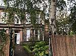 | |||
| 15 And 17 Hatton Place | 55°56′16″N 3°11′17″W | Category C(S) | 30399 | | |||
| 31 Mansionhouse Road | 55°56′06″N 3°11′20″W | Category B | 30424 | | |||
| 80-84 (Even Nos) Marchmont Crescent | 55°56′11″N 3°11′37″W | Category B | 30440 |  | |||
| 101-103 (Odd Nos) Marchmont Road | 55°56′08″N 3°11′38″W | Category B | 30446 |  | |||
| 3 Chalmers Crescent | 55°56′14″N 3°11′30″W | Category B | 30345 | | |||
| 3A Chalmers Crescent, Croston Lodge Nursing Home | 55°56′14″N 3°11′30″W | Category B | 30346 | | |||
| 2 Dick Place, Including Boundary Walls | 55°56′04″N 3°10′53″W | Category B | 30357 |  | |||
| 38 Dick Place, Stables, Including Boundary Wall | 55°55′59″N 3°11′17″W | Category B | 30364 | | |||
| 38 Findhorn Place Including Boundary Walls, Gatepiers And Pedestrian Gateway | 55°56′05″N 3°10′50″W | Category B | 30370 |  | |||
| 61-65 (Odd Nos) Fountainhall Road Including Boundary Walls | 55°55′49″N 3°11′08″W | Category B | 30375 | | |||
| George Street, At St Andrew Square, Pair Of K6 Telephone Kiosks | 55°57′14″N 3°11′40″W | Category B | 30248 | | |||
| High Street, Chalmer's Close, K6 Telephone Kiosks | 55°57′02″N 3°11′08″W | Category B | 30255 |  | |||
| 30 Corstorphine Road, Tor Nursing Home, Including Gate Lodge, Gatepiers, Railings And Boundary Walls | 55°56′44″N 3°14′49″W | Category B | 30256 | | |||
| 14 Cramond Road North, Lindores, Including Boundary Wall, Gatepiers And Gates | 55°58′27″N 3°17′26″W | Category C(S) | 30269 | | |||
| Waverley Station | 55°57′07″N 3°11′24″W | Category A | 30270 | | |||
| 20, 21, 22 Damside, Including Outbuilding | 55°57′08″N 3°13′06″W | Category C(S) | 30277 | | |||
| 11 New Market Road, Corn Exchange | 55°55′38″N 3°14′54″W | Category B | 30282 | | |||
| Roseburn Terrace, Former Railway Bridge | 55°56′44″N 3°13′55″W | Category B | 30287 | | |||
| 32 Canonmills | 55°57′45″N 3°11′57″W | Category C(S) | 30288 | | |||
| 1-6 (Inclusive Nos) Market Street, City Art Centre | 55°57′03″N 3°11′21″W | Category A | 30139 | |
Key
The scheme for classifying buildings in Scotland is:
- Category A: "buildings of national or international importance, either architectural or historic; or fine, little-altered examples of some particular period, style or building type."[1]
- Category B: "buildings of regional or more than local importance; or major examples of some particular period, style or building type, which may have been altered."[1]
- Category C: "buildings of local importance; lesser examples of any period, style, or building type, as originally constructed or moderately altered; and simple traditional buildings which group well with other listed buildings."[1]
In March 2016 there were 47,288 listed buildings in Scotland. Of these, 8 per cent were Category A, and 50 per cent were Category B, with the rest listed at Category C.[2]
Notes
- Sometimes known as OSGB36, the grid reference (where provided) is based on the British national grid reference system used by the Ordnance Survey.
• "Guide to National Grid". Ordnance Survey. Retrieved 12 December 2007.
• "Get-a-map". Ordnance Survey. Retrieved 17 December 2007. - Historic Environment Scotland assign a unique alphanumeric identifier to each designated site in Scotland, for listed buildings this always begins with "LB", for example "LB12345".
References
- All entries, addresses and coordinates are based on data from Historic Scotland. This data falls under the Open Government Licence
- "What is Listing?". Historic Environment Scotland. Retrieved 29 May 2018.
- Scotland's Historic Environment Audit 2016 (PDF). Historic Environment Scotland and the Built Environment Forum Scotland. pp. 15–16. Retrieved 29 May 2018.
This article is issued from Wikipedia. The text is licensed under Creative Commons - Attribution - Sharealike. Additional terms may apply for the media files.