List of listed buildings in Edinburgh/23
List
| Name | Location | Date Listed | Grid Ref. [note 1] | Geo-coordinates | Notes | LB Number [note 2] | Image |
|---|---|---|---|---|---|---|---|
| 27-33 (Odd Nos) Regent Street (Marionville) | 55°57′11″N 3°06′41″W | Category C(S) | 27549 |  | |||
| 65 Morningside Road, Flodden Lodge | 55°55′54″N 3°12′34″W | Category C(S) | 27561 | | |||
| Maitland's Bridge, River Almond At Kirkliston | 55°56′58″N 3°24′18″W | Category B | 27563 | | |||
| Newbridge Village, Bridge Street, Newbridge Inn | 55°56′22″N 3°24′29″W | Category C(S) | 27575 | | |||
| 28 Hermitage Gardens | 55°55′17″N 3°12′29″W | Category B | 27447 | | |||
| 26/1-6 Trafalgar Street (Former Lyon's Bakery); Eh6 4Df | 55°58′27″N 3°11′08″W | Category C(S) | 27450 | | |||
| 114 And 116 Portobello High Street | 55°57′14″N 3°06′56″W | Category C(S) | 27458 | | |||
| Kirkliston Village, High Street, Parish Church Hall (Former Free Church) | 55°57′16″N 3°24′07″W | Category B | 27462 | | |||
| Newhaven Main Street, Ruins Of St Mary And St James Chapel | 55°58′50″N 3°11′45″W | Category B | 27475 | | |||
| Kirkliston Village, 17 High Street | 55°57′15″N 3°24′05″W | Category C(S) | 27485 | | |||
| 17 And 17A Jordan Lane | 55°55′38″N 3°12′20″W | Category C(S) | 27497 | | |||
| 39 And 41 (Formerly 29 And 31) Greenhill Gardens, Bowmont Tower | 55°55′58″N 3°12′20″W | Category A | 27366 |  | |||
| Heriot-Watt University, Riccarton Estate, North Gate Lodge, Gatepiers And Screen Walls | 55°55′01″N 3°19′16″W | Category A | 27369 | | |||
| 38 Marlborough Street (Leven Lodge) | 55°57′13″N 3°06′33″W | Category C(S) | 27371 | | |||
| 7 And 9 Greenhill Park With Boundary Wall | 55°56′01″N 3°12′29″W | Category C(S) | 27380 | | |||
| 46 And 48 Portland Street With Boundary Walls; Eh6 4Ba | 55°58′38″N 3°11′00″W | Category C(S) | 27382 | | |||
| 31/1,2,3-33 (Odd Numbers) Spylaw Road | 55°55′56″N 3°13′09″W | Category C(S) | 27390 | | |||
| 52-60 (Even Nos) Portobello High Street | 55°57′18″N 3°07′03″W | Category B | 27438 | | |||
| Ingliston House Lodge With Gatepiers And Boundary Walls | 55°56′17″N 3°22′01″W | Category B | 27443 | | |||
| 3-7 (Odd Nos) Marlborough Street | 55°57′08″N 3°06′41″W | Category C(S) | 27294 | | |||
| 9-19 (Odd Nos) Pitt Street With Railings And Lamp Standard; Eh6 4Bx | 55°58′24″N 3°11′16″W | Category B | 27298 | | |||
| 60 Constitution Street | 55°58′28″N 3°10′04″W | Category B | 27302 | | |||
| 3 And 5 Portland Place And 1-3 (Inclusive Nos) Portland Terrace With Railings; Eh6 6La And Eh6 6Lz Respectively | 55°58′40″N 3°10′49″W | Category B | 27312 | | |||
| 5 And 7 Polwarth Terrace | 55°56′11″N 3°12′58″W | Category C(S) | 27314 | | |||
| 74 And 76 Constitution Street | 55°58′27″N 3°10′04″W | Category C(S) | 27316 | | |||
| Gogar Station Road, Gogar Stables (Former Carriage Block) | 55°55′59″N 3°19′47″W | Category C(S) | 27320 | | |||
| 7 Greenhill Gardens | 55°56′08″N 3°12′22″W | Category B | 27338 | | |||
| 17 Greenhill Gardens, Hopefield, With Boundary Walls And Gatepiers | 55°56′05″N 3°12′22″W | Category C(S) | 27359 | | |||
| 83, 85 And 85A Colinton Road | 55°55′48″N 3°13′19″W | Category C(S) | 27219 | | |||
| 119 Constitution Street, St James's Church With Church Officer's House, Hall, Boundary Walls And Gatepiers | 55°58′21″N 3°10′03″W | Category B | 27226 | | |||
| Montpelier Bruntsfield Primary School And Janitor's House | 55°56′15″N 3°12′35″W | Category B | 27238 | 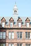 | |||
| 11 East Brighton Crescent | 55°57′02″N 3°06′59″W | Category B | 27239 | | |||
| 18 Corrennie Gardens | 55°55′14″N 3°12′24″W | Category B | 27241 | | |||
| 14-18 (Even Nos) North Fort Street And 7 (1F And 2F) Madeira Place With Garden Walls; Eh6 4Ex And Eh6 4An Respectively | 55°58′31″N 3°11′02″W | Category C(S) | 27243 | | |||
| Morningside Road Christ Church Episcopal With Boundary Walls_Railings And Gatepiers | 55°56′04″N 3°12′38″W | Category B | 27262 |  | |||
| 161 And 163 Constitution Street And 22 Laurie Street | 55°58′15″N 3°10′14″W | Category B | 27272 | | |||
| 25 Falcon Gardens | 55°55′49″N 3°12′16″W | Category C(S) | 27273 | | |||
| Sacred Heart, Convent Of The Main Building And Chapel 219 Colinton Road Craiglockhart | 55°55′05″N 3°14′23″W | Category B | 27274 | | |||
| 24A Broughton Street (Former Albany Street Chapel), Including Railings And Gate | 55°57′27″N 3°11′20″W | Category A | 27157 | | |||
| 23 Pittville Street | 55°57′07″N 3°06′25″W | Category C(S) | 27160 | | |||
| Glasgow Road, Gogar Park | 55°56′14″N 3°19′46″W | Category C(S) | 27169 | | |||
| 25 And 27 Pittville Street | 55°57′07″N 3°06′24″W | Category B | 27170 | | |||
| South Clerk Street Queens Hall | 55°56′28″N 3°10′54″W | Category A | 27176 | .jpg) | |||
| 63 And 63A Colinton Road With Garden House, Boundary Walls And Gatepiers | 55°55′54″N 3°12′57″W | Category B | 27184 | | |||
| 22 And 22A Merchiston Park | 55°56′16″N 3°12′53″W | Category C(S) | 27207 | | |||
| Jeffrey Street, Old St Paul's Church (Episcopal), Including Boundary Wall And Vestry Building | 55°57′04″N 3°11′14″W | Category B | 27212 | 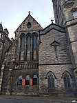 | |||
| 101-109 (Odd Nos) Constitution Street | 55°58′23″N 3°10′06″W | Category B | 27218 | | |||
| 20 Seafield Road, Seafield Crematorium With Boundary Wall, Memorial Garden Wall And Gateway | 55°58′11″N 3°08′51″W | Category B | 27095 | | |||
| 18 And 20 Brighton Place | 55°57′08″N 3°06′57″W | Category B | 27097 | | |||
| Glasgow Road, Castle Gogar Bridge | 55°56′30″N 3°20′08″W | Category B | 27102 | | |||
| Casselbank Street And 17 Kirk Street, South Leith Baptist Church | 55°58′13″N 3°10′26″W | Category C(S) | 27108 | | |||
| Mayfield Road And West Mayfield, Mayfield Salisbury Church, Including Church Hall, Gatepiers And Boundary Walls | 55°55′59″N 3°10′37″W | Category B | 27119 | | |||
| 4 And 5 Casselbank Street | 55°58′13″N 3°10′25″W | Category C(S) | 27126 | | |||
| Glasgow Road, Gogar Mount House, N Lodge, Gates, Gatepiers, Walls And Railings | 55°56′11″N 3°20′54″W | Category B | 27135 | | |||
| 1 And 2 Lockharton Gardens With Railings And Gatepiers | 55°55′35″N 3°13′56″W | Category A | 27137 | | |||
| 29-31A (Odd Nos) And 35 Constitution Street And 9 Baltic Street, Former Corn Exchange | 55°58′33″N 3°09′58″W | Category A | 27140 | | |||
| 13-17 (Odd Nos) Pittville Street (Pittville And Dundee) | 55°57′06″N 3°06′25″W | Category B | 27151 | | |||
| 32-44 (Even Nos) Ferry Road; Eh6 4Ae | 55°58′31″N 3°10′51″W | Category C(S) | 27020 | | |||
| Dalmahoy House | 55°54′14″N 3°22′10″W | Category A | 27021 | | |||
| 75 And 77 Restalrig Road With Boundary Wall | 55°58′04″N 3°09′28″W | Category C(S) | 27024 | | |||
| 25 Bridge Street, Buchan Pottery Kilns | 55°57′23″N 3°06′56″W | Category B | 27036 | | |||
| 26 Bonnington Road | 55°58′20″N 3°10′34″W | Category C(S) | 27037 | | |||
| 9 And 11 Joppa Road | 55°56′57″N 3°06′05″W | Category C(S) | 27042 | | |||
| 250 Bonnington Road, Cardboard Box Works | 55°58′11″N 3°10′59″W | Category C(S) | 27047 | | |||
| 4 Church Hill, Strathmore House | 55°55′55″N 3°12′30″W | Category B | 27048 | | |||
| 86-90 (Even Nos) Ferry Road With Front Walls And Railings; Eh6 4Ah | 55°58′30″N 3°10′59″W | Category C(S) | 27050 | | |||
| 490, Lanark Road West With Boundary Wall | 55°53′20″N 3°20′14″W | Category C(S) | 27066 | | |||
| 10 Church Hill, Beech Lodge, With Conservatory, Gig House And Boundary Walls | 55°55′56″N 3°12′23″W | Category B | 27069 | | |||
| 1-3 Seafield Place, 2, 4 Seafield Road With Railings | 55°58′17″N 3°09′06″W | Category B | 27075 | | |||
| 14, 14B, C, D, E, Church Hill | 55°55′56″N 3°12′20″W | Category B | 27079 | | |||
| 14 Ettrick Road | 55°56′04″N 3°13′19″W | Category C(S) | 27084 | | |||
| 205 Ferry Road, Bonnington Bank House With Front Walls And Gatepiers; Eh6 4Nn | 55°58′25″N 3°11′24″W | Category C(S) | 26939 | | |||
| 215 (Gf And 1F) And 217 Ferry Road With Front Walls; Eh6 4Nn | 55°58′24″N 3°11′26″W | Category C(S) | 26963 | | |||
| Dalmahoy Estate, North Entrance | 55°54′29″N 3°22′06″W | Category B | 26964 | | |||
| 60 Johnsburn Road (Former S Lodge To Larch Grove) With Gatepiers And Boundary Wall | 55°52′51″N 3°20′59″W | Category C(S) | 26968 | | |||
| 42 Colinton Road With Boundary Walls And Gatepiers | 55°55′46″N 3°13′36″W | Category B | 26978 | | |||
| 18 Bellfield Street (Marantha) | 55°57′09″N 3°06′29″W | Category C(S) | 26981 | | |||
| Royal Terrace Greenside Parish Church (Church Of Scotland), Including Retaining Walls, Railings And Steps And Church Officer's Cottage | 55°57′25″N 3°10′56″W | Category A | 27007 | | |||
| 28 And 30 Ferry Road, Leith Library (Incorporating Registrar's Office), Leith Theatre And Thomas Morton Hall, Porter's Lodge, Gates And Railings; Eh6 4Ae | 55°58′32″N 3°10′48″W | Category B | 27009 |  | |||
| 3 And 5 Church Hill | 55°55′57″N 3°12′29″W | Category C(S) | 27017 | | |||
| 84 Cammo Road, Lennie Mains | 55°57′24″N 3°20′18″W | Category B | 26865 | | |||
| 52 Gorgie Road, Mecca Tivoli (New Tivoli Picture House) | 55°56′21″N 3°13′41″W | Category B | 26877 | 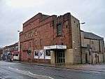 | |||
| 7-9 (Odd Nos) Smith's Place | 55°58′03″N 3°10′25″W | Category B | 26885 | | |||
| 11 Smith's Place | 55°58′03″N 3°10′24″W | Category B | 26897 | | |||
| 8 Bruntsfield Terrace And Boundary Wall | 55°56′11″N 3°12′22″W | Category B | 26899 | | |||
| 24 Colinton Road Redfern With Conservatory Sundial Boundary_Walls And Gatepiers | 55°55′53″N 3°13′09″W | Category C(S) | 26905 | | |||
| 3 Clifton Road, Victoria Cottage, Newbridge (Former School) And Boundary Wall | 55°55′18″N 3°25′14″W | Category B | 26915 | | |||
| 14 Hermitage Place, Park View House Hotel With Boundary Wall | 55°58′08″N 3°09′56″W | Category B | 26918 | | |||
| Craigiehall Temple (Off Cammo Road) | 55°57′36″N 3°19′50″W | Category A | 26928 | | |||
| 29-39 (Odd Nos) Bath Street | 55°57′15″N 3°06′41″W | Category B | 26806 | | |||
| 165 Leith Walk, Community Centre | 55°58′04″N 3°10′26″W | Category C(S) | 26807 | | |||
| 25 Bernard Street And 24 And 25 Maritime Street With Railings | 55°58′32″N 3°10′04″W | Category A | 26809 | | |||
| 14 Bath Street, The George, Formerly The County | 55°57′14″N 3°06′48″W | Category C(S) | 26818 | | |||
| 169-177 (Odd Nos) Leith Walk And 1 Smith's Place | 55°58′03″N 3°10′26″W | Category B | 26819 | | |||
| Slateford Road Bridge At Shandon Place | 55°56′05″N 3°13′57″W | Category C(S) | 26820 | | |||
| Slateford Road St Michael's Parish Church With Church Hall And Beadle's House Boundary Walls And Railings | 55°56′12″N 3°13′38″W | Category A | 26846 |  | |||
| Mansfield Place And East London Street, Former Catholic Apostolic Church (Latter Bellevue Reformed Baptist Church) With Railings | 55°57′35″N 3°11′26″W | Category A | 26849 | | |||
| 9 Lorne Street And Lorne Square, St Paul's Church And Hall, With Gatepiers | 55°57′58″N 3°10′26″W | Category B | 26859 | | |||
| Dalry Road, Dalry Cemetery Lodge | 55°56′26″N 3°13′27″W | Category B | 26786 | | |||
| Ashley House Stables And Kennels | 55°55′39″N 3°21′34″W | Category B | 26788 | | |||
| Bavelaw Castle With Stables And Outbuildings, Gatepiers And Boundary Wall | 55°51′04″N 3°19′53″W | Category A | 26701 | | |||
| 1-17 (Odd Nos) Albion Road And 190-194 (Even Nos) Easter Road | 55°57′43″N 3°10′14″W | Category C(S) | 26703 | | |||
| 8 Abbotsford Crescent | 55°55′54″N 3°12′46″W | Category C(S) | 26706 | | |||
| Bavelaw Road, Malleny Lodge With Boundary Wall | 55°53′09″N 3°20′23″W | Category C(S) | 26714 | | |||
| 41-43 (Odd Nos) Bavelaw Road, Balerno Bank Paper Mill Lodge With Boundary Wall | 55°52′59″N 3°20′19″W | Category C(S) | 26727 | | |||
| 30-38 (Even Nos) Dalmeny Street, Territorial Army Drill Hall | 55°57′52″N 3°10′28″W | Category B | 26729 | 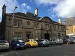 | |||
| 28 Academy Street, Leith Victoria Boxing Club | 55°58′15″N 3°10′10″W | Category C(S) | 26731 | | |||
| 23 And 23A Argyle Crescent | 55°56′55″N 3°06′17″W | Category B | 26737 | | |||
| 1-5 Baltic Street, Former Gas Works | 55°58′33″N 3°09′52″W | Category B | 26744 | | |||
| 1, 2 And 3 Greyfriars Place | 55°56′48″N 3°11′29″W | Category B | 18972 | | |||
| Dalmeny Village 1 And 2 Wester Dalmeny | 55°58′57″N 3°22′27″W | Category C(S) | 5530 | | |||
| Dalmeny Village, 1-9 (Consecutive Nos) Wester Dalmeny Steading | 55°58′56″N 3°22′32″W | Category C(S) | 5547 | | |||
| Dalmeny House, Leuchold Gate Lodge, Including Gatepiers | 55°59′14″N 3°22′02″W | Category B | 5506 | | |||
| Dundas Castle, Fountain Sundial | 55°58′31″N 3°24′49″W | Category A | 5513 | | |||
| Dundas Castle, Dovecot | 55°58′33″N 3°25′12″W | Category B | 5514 | | |||
| Dundas Castle, Castleloch, Including Ice House | 55°58′21″N 3°25′20″W | Category C(S) | 5518 | | |||
| 6-18 (Inclusive Numbers) Dundas Home Farm (Formerly Newbigging Steading) | 55°58′43″N 3°24′05″W | Category B | 5520 | | |||
| Westfield Farm House, Including Outbuilding And Boundary Walls | 55°58′34″N 3°26′06″W | Category C(S) | 5523 | | |||
| 5 Caroline Park And West Shore Road, Walled Garden To North Of Caroline Park House | 55°58′56″N 3°14′29″W | Category C(S) | 45784 | | |||
| 347A Pilton Avenue (And Crewe Road North), Telford College, Including Gymnasium And Entrance Gates | 55°58′18″N 3°14′11″W | Category B | 45799 | | |||
| 7 And 8 Swanston Village | 55°53′33″N 3°12′57″W | Category C(S) | 45845 | | |||
| 81-87 (Odd Nos) Broughton Street, Including Barony Bar | 55°57′30″N 3°11′22″W | Category B | 45931 | | |||
| 13-17 (Odd Nos) Forth Street | 55°57′28″N 3°11′14″W | Category B | 45947 | | |||
| Leith Walk, Shrub Place, Shrubhill Tramway Workshops And Power Station | 55°57′50″N 3°10′55″W | Category B | 45956 | | |||
| 38 And 40 Barony Street | 55°57′29″N 3°11′33″W | Category C(S) | 46117 | | |||
| 20-26A (Even Nos) Randolph Lane | 55°57′08″N 3°12′36″W | Category C(S) | 46121 | | |||
| 137 Grange Loan, St Roque Lodge | 55°55′52″N 3°11′50″W | Category C(S) | 46191 | | |||
| 143 Grange Loan, Astley Ainslie Hospital, Scientific Block | 55°55′42″N 3°11′56″W | Category C(S) | 46192 | | |||
| 143 Grange Loan, Astley Ainslie Hospital, Boundary Wall To Grange Loan, Canaan Lane, South Oswald Road And Cluny Place, Including Gateways | 55°55′52″N 3°11′55″W | Category C(S) | 46193 | | |||
| 138-140 (Even Nos) Glasgow Road | 55°56′28″N 3°18′32″W | Category C(S) | 46332 | | |||
| 30 And 32 Primrose Bank Road, Craigforth, With Gatepiers, Boundary Walls And Railings | 55°58′46″N 3°12′34″W | Category C(S) | 46743 | | |||
| 23 Russell Place, North Gothic Cottage, With Boundary Wall | 55°58′43″N 3°12′19″W | Category C(S) | 46746 | | |||
| 90 And 92 Trinity Road, Silverton, With Boundary Walls And Gatepiers | 55°58′38″N 3°12′22″W | Category B | 46751 | | |||
| Warriston Gardens, George Heriot's Recreation Ground, Cricket Pavilion | 55°58′16″N 3°12′10″W | Category C(S) | 46757 | | |||
| 85-87 (Odd Nos) Shandwick Place | 55°56′56″N 3°12′36″W | Category C(S) | 47731 | | |||
| 46-66 (Even Nos) Home Street, 1 And 3 Lochrin Place And 2 And 4 Lochrin Buildings | 55°56′33″N 3°12′14″W | Category C(S) | 47784 | | |||
| Newhalls Road, Hawes Pier | 55°59′30″N 3°23′10″W | Category C(S) | 47793 | | |||
| 6 Villa Road, Provost Lamp | 55°59′26″N 3°24′00″W | Category B | 47794 | | |||
| 44 Candlemaker Row | 55°56′49″N 3°11′30″W | Category C(S) | 47848 | | |||
| 29 Castle Terrace, Including Boundary Wall And Railings | 55°56′50″N 3°12′09″W | Category A | 47854 | | |||
| 83-85 Grassmarket | 55°56′52″N 3°11′40″W | Category B | 47872 | | |||
| 18-24 (Even Nos) Grassmarket, Beehive Inn | 55°56′51″N 3°11′50″W | Category B | 47873 |  | |||
| 94 Grassmarket | 55°56′53″N 3°11′42″W | Category B | 47878 | | |||
| 1-5 (Odd Nos) Grindlay Street And 21 Spittal Street | 55°56′48″N 3°12′11″W | Category C(S) | 47879 | | |||
| 10 - 14 (Even Nos) Lauriston Place, Including Boundary Wall, Gate And Railings | 55°56′42″N 3°11′44″W | Category B | 47887 | | |||
| 7 Victoria Terrace, Quaker Meeting House | 55°56′56″N 3°11′38″W | Category B | 47903 |  | |||
| Edinburgh Castle, Foog's Gate | 55°56′54″N 3°12′01″W | Category A | 48217 | | |||
| Edinburgh Castle, Governor's House | 55°56′55″N 3°12′04″W | Category A | 48219 |  | |||
| Edinburgh Castle, United Services Museum | 55°56′54″N 3°12′01″W | Category A | 48231 | 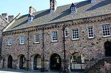 | |||
| Lawnmarket, North Side, Telephone Kiosks | 55°56′58″N 3°11′35″W | Category B | 48244 | .jpg) |
Key
The scheme for classifying buildings in Scotland is:
- Category A: "buildings of national or international importance, either architectural or historic; or fine, little-altered examples of some particular period, style or building type."[1]
- Category B: "buildings of regional or more than local importance; or major examples of some particular period, style or building type, which may have been altered."[1]
- Category C: "buildings of local importance; lesser examples of any period, style, or building type, as originally constructed or moderately altered; and simple traditional buildings which group well with other listed buildings."[1]
In March 2016 there were 47,288 listed buildings in Scotland. Of these, 8 per cent were Category A, and 50 per cent were Category B, with the rest listed at Category C.[2]
Notes
- Sometimes known as OSGB36, the grid reference (where provided) is based on the British national grid reference system used by the Ordnance Survey.
• "Guide to National Grid". Ordnance Survey. Retrieved 12 December 2007.
• "Get-a-map". Ordnance Survey. Retrieved 17 December 2007. - Historic Environment Scotland assign a unique alphanumeric identifier to each designated site in Scotland, for listed buildings this always begins with "LB", for example "LB12345".
References
- All entries, addresses and coordinates are based on data from Historic Scotland. This data falls under the Open Government Licence
- "What is Listing?". Historic Environment Scotland. Retrieved 29 May 2018.
- Scotland's Historic Environment Audit 2016 (PDF). Historic Environment Scotland and the Built Environment Forum Scotland. pp. 15–16. Retrieved 29 May 2018.
This article is issued from Wikipedia. The text is licensed under Creative Commons - Attribution - Sharealike. Additional terms may apply for the media files.