List of listed buildings in Edinburgh/17
List
| Name | Location | Date Listed | Grid Ref. [note 1] | Geo-coordinates | Notes | LB Number [note 2] | Image |
|---|---|---|---|---|---|---|---|
| 17-21 (Odd Nos) Gilmore Place, Including Boundary Walls | 55°56′30″N 3°12′16″W | Category B | 44952 |  | |||
| 26 Clermiston Road Including Boundary Walls, Postbox And Outhouse | 55°56′40″N 3°16′49″W | Category C(S) | 44748 | | |||
| 26 St John's Road Including Boundary Walls And Gatepiers | 55°56′34″N 3°16′41″W | Category C(S) | 44756 | | |||
| Corstorphine Road, 1-5 (Inclusive Nos) Downie Terrace Including Boundary Walls | 55°56′31″N 3°16′02″W | Category C(S) | 44761 | | |||
| Lochend Road South, Lochend Park, Old Water House | 55°57′43″N 3°09′37″W | Category B | 44627 | | |||
| 1 South Bridge, Bank Hotel | 55°57′00″N 3°11′14″W | Category B | 44598 |  | |||
| 21 West Mayfield, Including Boundary Walls | 55°56′00″N 3°10′32″W | Category C(S) | 44441 | | |||
| 1 Burgess Terrace, Including Boundary Walls And Pedstrian Gateway | 55°56′02″N 3°10′04″W | Category C(S) | 44204 | | |||
| 18 - 22 (Even Nos) Duncan Street, Including Duncan Street Garage | 55°56′05″N 3°10′42″W | Category B | 44213 | 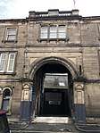 | |||
| 7 And 9 Granby Road, Including Boundary Walls | 55°55′41″N 3°10′20″W | Category C(S) | 44221 | | |||
| 169 Mayfield Road And 43 Esslemont Road, Including Boundary Walls | 55°55′28″N 3°10′17″W | Category B | 44226 | | |||
| Mayfield Road And West Mains Road, University Of Edinburgh, King's Buildings, Civil And Environmental Engineering (Formerly Animal Genetics) | 55°55′23″N 3°10′41″W | Category B | 44227 | | |||
| 32 And 33 Queens Crescent, Including Boundary Walls | 55°56′02″N 3°10′14″W | Category C(S) | 44255 | | |||
| 20 Cammo Crescent, Including Gatepiers And Boundary Wall | 55°57′38″N 3°18′33″W | Category C(S) | 43933 | | |||
| 140 Balgreen Road, Jenners Depository, With Lodge, Garages, Gatepiers, Gates And Railings | 55°56′19″N 3°15′08″W | Category B | 43847 |  | |||
| Brunswick Road, Leith Walk Primary School, Including No 8 Brunswick Road (Lodge), Boundary Walls And Railings | 55°57′37″N 3°10′45″W | Category B | 43685 | | |||
| 1 Craighall Avenue, Trinity Academy | 55°58′34″N 3°11′45″W | Category B | 43687 | | |||
| 98 And 100 Ferry Road | 55°58′29″N 3°11′03″W | Category C(S) | 43692 | | |||
| Newhaven, New Lighthouse | 55°58′56″N 3°11′48″W | Category B | 43712 | | |||
| 5 Peacock Court | 55°58′50″N 3°11′35″W | Category C(S) | 43722 | | |||
| 4 And 5 Wester Close | 55°58′50″N 3°11′43″W | Category C(S) | 43728 | | |||
| 2 And 3 Westmost Close | 55°58′49″N 3°11′45″W | Category C(S) | 43731 | | |||
| 6 Wester Coates Road, Redmount, Including Boundary Walls | 55°56′50″N 3°13′45″W | Category B | 43573 | | |||
| 1, 3, 5 And 7 Dean Path, The Old School With Former Lodge, Boundary Walls And Railings | 55°57′09″N 3°13′03″W | Category B | 43495 | 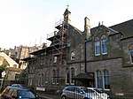 | |||
| 63- 65 (Odd Nos) Grassmarket | 55°56′51″N 3°11′42″W | Category B | 43496 | 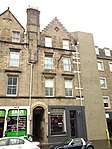 | |||
| 5-9 (Odd Nos) Hill Street | 55°57′13″N 3°12′07″W | Category A | 43296 | | |||
| 37 Hill Street Lane North | 55°57′13″N 3°12′10″W | Category B | 43306 | | |||
| 3 Hope Street | 55°57′02″N 3°12′28″W | Category B | 43307 | | |||
| 38-40 North West Thistle Street Lane | 55°57′14″N 3°12′02″W | Category C(S) | 43312 | | |||
| 88-90 (Inclusive Nos) Princes Street | 55°57′07″N 3°11′54″W | Category B | 43323 | | |||
| 129 And 131 Rose Street | 55°57′07″N 3°12′09″W | Category B | 43331 | | |||
| 3 South West Thistle Street Lane | 55°57′13″N 3°11′53″W | Category C(S) | 43350 | | |||
| 41-45 (Odd Nos) Thistle Street | 55°57′15″N 3°11′57″W | Category B | 43357 | | |||
| 6 Young Street Lane South | 55°57′10″N 3°12′20″W | Category B | 43371 | | |||
| 4 Claverhouse Drive With Boundary Walls | 55°55′03″N 3°09′14″W | Category B | 43235 | | |||
| 6 Claverhouse Drive With Boundary Walls | 55°55′03″N 3°09′16″W | Category C(S) | 43236 | | |||
| Frogston Road East, Mortonhall House, Dovecot | 55°54′13″N 3°10′50″W | Category C(S) | 43237 | | |||
| Frogston Road East, Mortonhall House, Factor's House | 55°54′15″N 3°10′52″W | Category C(S) | 43238 | | |||
| Gilmerton, The Drum, West Lodge, Gatepiers, Gates And Railings | 55°54′31″N 3°07′13″W | Category B | 43253 | | |||
| 40 And 42 George Street With Railings | 55°57′12″N 3°11′53″W | Category C(S) | 43289 | | |||
| 9 Cameron House Avenue, Cameron Nursery School | 55°55′52″N 3°09′39″W | Category B | 43142 | | |||
| 2-8 (Even Nos) Kilmaurs Terrace | 55°56′03″N 3°10′00″W | Category C(S) | 43154 | | |||
| 7 And 9 Marchhall Crescent | 55°56′10″N 3°10′04″W | Category C(S) | 43156 | | |||
| 2 Marchhall Road, Queens Park Nursing Home | 55°56′13″N 3°10′04″W | Category C(S) | 43158 | | |||
| 55 Peffermill Road, Morgan Lodge | 55°55′56″N 3°09′19″W | Category C(S) | 43164 | | |||
| 10 And 12 Priestfield Road (Priestville Guest House) | 55°56′08″N 3°10′01″W | Category C(S) | 43169 | | |||
| 23, 24 And 25 High Street | 55°59′25″N 3°23′45″W | Category B | 40379 | | |||
| 27, 28 And 29 High Street | 55°59′24″N 3°23′44″W | Category B | 40380 | | |||
| 58, 59, 60, 61 And 62 High Street, Including Railings And Boundary Walls | 55°59′24″N 3°23′36″W | Category B | 40384 | | |||
| 38 And 40 High Street And 21 East Terrace, Black Castle | 55°59′23″N 3°23′42″W | Category A | 40386 | 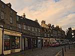 | |||
| The Vennel, Old Burial Ground, Boundary Walls, Gatepiers, Bee-Boles And Monuments | 55°59′22″N 3°23′43″W | Category B | 40405 | | |||
| West Terrace, Tolbooth | 55°59′25″N 3°23′49″W | Category A | 40411 | | |||
| Queensferry Harbour | 55°59′31″N 3°23′46″W | Category B | 40371 |  | |||
| 148 (Formerly 18) Whitehouse Loan The Elms Including Pedestrian Gateway, Gatepiers And Boundary Walls | 55°55′56″N 3°12′03″W | Category B | 30672 | | |||
| 9 Whitehouse Terrace Incl Gatepiers And Boundary Walls | 55°55′55″N 3°11′38″W | Category B | 30678 | | |||
| 44 (Formerly 42) South Oswald Road Scottish Agricultural College Including Gatepiers | 55°55′44″N 3°11′42″W | Category B | 30594 | | |||
| 15-17 Spottiswoode Street | 55°56′19″N 3°11′54″W | Category B | 30598 | | |||
| 6 Spottiswoode Street | 55°56′21″N 3°11′52″W | Category B | 30599 | | |||
| 88 Stratheran Rd St Margarets Tower Incl Gatepiers & Walls | 55°56′03″N 3°11′57″W | Category B | 30605 | | |||
| 49-51 (Odd Nos) Warrender Park Road | 55°56′19″N 3°11′45″W | Category B | 30620 | | |||
| 67 Warrender Park Road | 55°56′19″N 3°11′50″W | Category B | 30625 | | |||
| 69 Warrender Park Road | 55°56′19″N 3°11′51″W | Category B | 30626 | | |||
| 113-115 (Odd Nos) Warrender Park Road | 55°56′17″N 3°11′59″W | Category B | 30633 | | |||
| 102 Warrender Park Road Former Usher Institute | 55°56′17″N 3°11′54″W | Category B | 30644 | | |||
| 8-10 (Incl Nos) Warrender Park Terrace Including Railings | 55°56′21″N 3°11′47″W | Category B | 30647 | | |||
| 27-29 (Inclusive Nos) Warrender Park Terrace | 55°56′21″N 3°11′56″W | Category B | 30654 | | |||
| 32A Warrender Park Terrace | 55°56′20″N 3°11′57″W | Category B | 30656 | | |||
| 113A Whitehouse Loan Gillis College Former School | 55°56′04″N 3°12′03″W | Category B | 30663 | | |||
| 125 Grange Loan Incl Boundary Walls | 55°55′51″N 3°11′33″W | Category B | 30507 | | |||
| 8 Greenhill Gardens | 55°56′09″N 3°12′20″W | Category B | 30513 | | |||
| 42 Greenhill Gardens Roman Catholic Archiepiscopal Chapel | 55°55′57″N 3°12′17″W | Category A | 30521 | | |||
| 15 And 15A Greenhill Terrace | 55°56′07″N 3°12′11″W | Category C(S) | 30524 | | |||
| 2 & 4 Kilgraston Rd Incl Stable Block And Boundary Walls | 55°56′00″N 3°11′38″W | Category B | 30527 | | |||
| 23-29 Marchmont Cres & 32-34 Warrender Park Road | 55°56′17″N 3°11′37″W | Category B | 30531 | 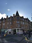 | |||
| 57 Marchmont Road | 55°56′14″N 3°11′39″W | Category B | 30549 | | |||
| 118-122 (Even Nos) Marchmont Road | 55°56′09″N 3°11′41″W | Category B | 30564 | | |||
| 124 Marchmont Road 2 And 4 Thirlestane Road | 55°56′08″N 3°11′41″W | Category B | 30565 | | |||
| 2 Marchmont Street | 55°56′18″N 3°12′03″W | Category B | 30569 | | |||
| 35 Mortonhall Rd With Lamp Posts Boundary Walls Gates & Gate | 55°55′38″N 3°11′41″W | Category A | 30579 | | |||
| 4 And 4A Mortonhall R0Ad Cardon Including Gatepiers And Boundary Walls | 55°55′41″N 3°11′21″W | Category B | 30580 | | |||
| 5-9 (Odd (Nos) Roseneath Terrace | 55°56′21″N 3°11′32″W | Category B | 30466 | 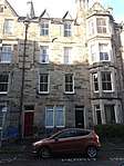 | |||
| 5 And 7 Sciennes House Place, Formerly Sciennes Hill House | 55°56′16″N 3°10′55″W | Category B | 30477 |  | |||
| 3 And 3A South Lauder Road And 52 Fountainhall Road, Claremont, Including Gatepiers, Pedestrian Gateways And Boundary Walls | 55°55′54″N 3°10′56″W | Category B | 30482 | | |||
| 1 Alvanley Terrace & 153-161 (Odd Nos)Warrender Park Road | 55°56′15″N 3°12′09″W | Category B | 30492 | | |||
| 56 Fountainhall Road | 55°55′53″N 3°11′00″W | Category C(S) | 30378 | | |||
| 60 Fountainhall Road Including Boundary Wall And Gatepiers | 55°55′52″N 3°11′04″W | Category C(S) | 30379 | | |||
| Grange Loan And Lover's Loan, Pillar Surmounted By Wyvern | 55°55′53″N 3°11′13″W | Category B | 30380 | 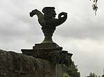 | |||
| Kilgraston Road, Marchmont St Giles Church (Formerly Grange Parish Church) Including Church Hall, 1A Kilgraston Road (Church Officer's House), And Boundary Walls | 55°56′03″N 3°11′35″W | Category B | 30400 |  | |||
| 1 Kilgraston Road And 11 Beaufort Road | 55°56′04″N 3°11′36″W | Category B | 30401 | | |||
| 41 And 43 Lauder Road | 55°56′12″N 3°11′15″W | Category B | 30408 | | |||
| 45 And 47 Lauder Road | 55°56′13″N 3°11′16″W | Category B | 30409 | | |||
| 49 And 51 Lauder Road | 55°56′14″N 3°11′16″W | Category B | 30410 | | |||
| 18B And 18C Lauder Road, Northwood House, Including Gatepiers And Boundary Walls | 55°56′01″N 3°11′11″W | Category C(S) | 30412 | | |||
| 20 Lauder Road And 31B Dick Place, Including Boundary Wall And Pedestrian Gateways | 55°56′02″N 3°11′12″W | Category C(S) | 30413 | | |||
| 42 Lauder Road | 55°56′12″N 3°11′19″W | Category B | 30417 | | |||
| 44 Lauder Road | 55°56′13″N 3°11′19″W | Category B | 30418 | | |||
| 4 Mansionhouse Road | 55°56′14″N 3°11′22″W | Category C(S) | 30428 | | |||
| 24 Mansionhouse Road | 55°56′06″N 3°11′18″W | Category B | 30429 | | |||
| 26 And 26A Mansionhouse Road | 55°56′06″N 3°11′17″W | Category B | 30430 | | |||
| 21 Dean Park Street, St Bernard's Education Centre (Formerly St Bernard's Primary School), Including Janitor's House, Gates, Gatepiers And Boundary Railings | 55°57′28″N 3°12′52″W | Category B | 30316 | | |||
| 137 Dundee Street, Fountainbridge Public Library | 55°56′24″N 3°13′06″W | Category B | 30322 | | |||
| 57 Albion Road, Norton Park Annexe Technical Block, With Outbuilding, Boundary Walls, Gatepiers, Gates And Railings | 55°57′41″N 3°10′00″W | Category B | 30323 | | |||
| 4 And 5 Argyle Place | 55°56′21″N 3°11′28″W | Category C(S) | 30334 | | |||
| 15-17 (Inclusive) Argyle Place | 55°56′18″N 3°11′30″W | Category B | 30337 | 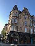 | |||
| 6 Chalmers Crescent | 55°56′14″N 3°11′27″W | Category C(S) | 30348 | | |||
| 10 Chalmers Crescent With Boundary Walls And Gatepiers | 55°56′12″N 3°11′27″W | Category B | 30349 | | |||
| 3 And 3A Dalrymple Crescent Including Boundary Wall | 55°56′01″N 3°11′00″W | Category B | 30350 | | |||
| 9 And 11 Dick Place Including Boundary Walls | 55°56′05″N 3°10′57″W | Category C(S) | 30353 | | |||
| 55 Dick Place | 55°55′59″N 3°11′30″W | Category B | 30354 | | |||
| 8 And 8A Dick Place And Carriage House | 55°56′03″N 3°10′57″W | Category B | 30360 |  | |||
| 18 And 18A Dick Place | 55°56′03″N 3°11′03″W | Category B | 30361 | | |||
| 36 And 36A Dick Place, Hazelwood With Gates, Gatepiers And Boundary Walls | 55°56′01″N 3°11′16″W | Category B | 30362 | | |||
| 40 And 42 Dick Place | 55°55′59″N 3°11′22″W | Category B | 30366 | | |||
| 36 Findhorn Place Including Boundary Walls And Pedestrian Gateway | 55°56′05″N 3°10′51″W | Category B | 30369 |  | |||
| Cramond Glebe Road, K6 Telephone Kiosk At The Cramond Inn | 55°58′46″N 3°18′01″W | Category B | 30228 | | |||
| Lawnmarket (South Side) Telephone Kiosk | 55°56′58″N 3°11′35″W | Category B | 30232 | _(1).jpg) | |||
| Market Street And Waverley Bridge, Police Box | 55°57′03″N 3°11′30″W | Category B | 30239 |  | |||
| Dean Terrace, Police Box | 55°57′28″N 3°12′33″W | Category B | 30241 | | |||
| 1-48 (Inclusive Nos) Ravelston Garden | 55°57′07″N 3°14′51″W | Category A | 30264 | | |||
| The Vennel, Former Portsburgh Chapel, Including Boundary Wall, Railings, Gate And Gateway | 55°56′47″N 3°11′51″W | Category B | 30266 |  | |||
| 6 New Market Road, St Cuthbert`S Association Cattle Depot | 55°55′37″N 3°14′50″W | Category B | 30280 | | |||
| 8-9 New Market Road, Newmarket Pockets, Former Market Refreshment Rooms | 55°55′38″N 3°14′51″W | Category C(S) | 30281 | | |||
| 69-71 Whitehill Street, Newcraighall Parish Church And Church Hall Including Boundary Walls | 55°56′07″N 3°05′16″W | Category C(S) | 30286 | | |||
| 9 Easter Belmont Road | 55°56′51″N 3°15′20″W | Category C(S) | 30294 | | |||
| 22 Russell Place, South Gothic Cottage, With Boundary Wall | 55°58′42″N 3°12′18″W | Category B | 30156 | | |||
| 299 Colinton Road, Inchdrewer, With Boundary Wall, Gatepiers And Outbuildings | 55°54′35″N 3°14′59″W | Category B | 30212 | | |||
| 152-55 (Consecutive Nos) Lower Granton Road, Including Gatepiers And Rear Outbuildings | 55°58′50″N 3°13′19″W | Category B | 30213 | | |||
| Craiglockhart House Craiglockhart Dell Road And Craiglockhart Loan | 55°55′15″N 3°14′50″W | Category B | 30055 | | |||
| 50-54A (Even Nos) Broughton Street, Including Railings | 55°57′31″N 3°11′25″W | Category B | 30072 | | |||
| 3 And 5 Gayfield Street Including Boundary Wall | 55°57′33″N 3°11′12″W | Category C(S) | 30098 | | |||
| 16 George Street | 55°57′12″N 3°11′46″W | Category C(S) | 30106 | | |||
| 1A, 1-4 Inverleith Row And 1A Inverleith Terrace | 55°57′52″N 3°12′11″W | Category B | 30120 | | |||
| Lanark Road 45 Old Manse, Slateford | 55°55′20″N 3°14′56″W | Category B | 30122 | | |||
| 40 Lauriston Street | 55°56′42″N 3°12′03″W | Category B | 30128 | | |||
| 57-61A (Odd Nos) York Place, Including Railings | 55°57′23″N 3°11′19″W | Category A | 29972 | | |||
| 18 York Place, Including Railings | 55°57′23″N 3°11′30″W | Category A | 29982 | | |||
| 26 York Place, Including Railings And Lamps | 55°57′23″N 3°11′27″W | Category A | 29986 | | |||
| 28 York Place, Including Railings And Lamps | 55°57′23″N 3°11′27″W | Category A | 29987 | | |||
| 30 York Place, Including Railings And Lamp | 55°57′23″N 3°11′26″W | Category A | 29988 | | |||
| 38 York Place, Including Railings And Lamp | 55°57′24″N 3°11′24″W | Category A | 29992 | | |||
| 13 Young Street | 55°57′11″N 3°12′20″W | Category A | 30001 | | |||
| 7 East Broughton Place And 11, 12 Gayfield Street (Former Broughton St Mary's Church Centre) | 55°57′32″N 3°11′13″W | Category B | 30010 | | |||
| Greenside Place, Lady Glenorchy's Church | 55°57′24″N 3°11′08″W | Category C(S) | 30011 |  | |||
| 26 Lauriston Street, Lauriston Hall (Halls And Presbytery Of Church Of Sacred Heart) | 55°56′42″N 3°12′04″W | Category B | 30013 | | |||
| West Savile Terrace And Blackford Avenue, Reid Memorial Church, Including Cloister, Church Officer's House, Session House, Hall, Loggia And Boundary Walls | 55°55′35″N 3°11′03″W | Category A | 30015 | | |||
| 45 Lanark Road, Former Slateford Up Church, Including Gateway To Lanark Road | 55°55′21″N 3°14′57″W | Category B | 30017 | | |||
| 21-31 (Odd Nos) Lothian Road, Former Caley Cinema | 55°56′54″N 3°12′22″W | Category B | 30021 |  | |||
| Broughton Road And 154 Mcdonald Road, Broughton Schools With Janitor's House And Playshelter, Boundary Walls, Gatepiers And Railings | 55°57′56″N 3°11′18″W | Category B | 30041 | | |||
| Donaldson's School For The Deaf Lodges And Gates, Henderson Row | 55°57′37″N 3°12′20″W | Category B | 30042 | | |||
| Edinburgh Academy West Lodge, Railings And Gates, Henderson Row | 55°57′37″N 3°12′19″W | Category B | 30043 | |
Key
The scheme for classifying buildings in Scotland is:
- Category A: "buildings of national or international importance, either architectural or historic; or fine, little-altered examples of some particular period, style or building type."[1]
- Category B: "buildings of regional or more than local importance; or major examples of some particular period, style or building type, which may have been altered."[1]
- Category C: "buildings of local importance; lesser examples of any period, style, or building type, as originally constructed or moderately altered; and simple traditional buildings which group well with other listed buildings."[1]
In March 2016 there were 47,288 listed buildings in Scotland. Of these, 8 per cent were Category A, and 50 per cent were Category B, with the rest listed at Category C.[2]
Notes
- Sometimes known as OSGB36, the grid reference (where provided) is based on the British national grid reference system used by the Ordnance Survey.
• "Guide to National Grid". Ordnance Survey. Retrieved 12 December 2007.
• "Get-a-map". Ordnance Survey. Retrieved 17 December 2007. - Historic Environment Scotland assign a unique alphanumeric identifier to each designated site in Scotland, for listed buildings this always begins with "LB", for example "LB12345".
References
- All entries, addresses and coordinates are based on data from Historic Scotland. This data falls under the Open Government Licence
- "What is Listing?". Historic Environment Scotland. Retrieved 29 May 2018.
- Scotland's Historic Environment Audit 2016 (PDF). Historic Environment Scotland and the Built Environment Forum Scotland. pp. 15–16. Retrieved 29 May 2018.
This article is issued from Wikipedia. The text is licensed under Creative Commons - Attribution - Sharealike. Additional terms may apply for the media files.