List of listed buildings in Edinburgh/16
List
| Name | Location | Date Listed | Grid Ref. [note 1] | Geo-coordinates | Notes | LB Number [note 2] | Image |
|---|---|---|---|---|---|---|---|
| 26 Bellfield Street | 55°57′10″N 3°06′29″W | Category C(S) | 27026 |  | |||
| 46 Ferry Road With Front Wall And Railings And Shelter; Eh6 4Ae | 55°58′31″N 3°10′52″W | Category B | 27030 | | |||
| 64-70 (Even Nos) And 70A Ferry Road With Front Walls And Railings; Eh6 4Ah | 55°58′30″N 3°10′55″W | Category C(S) | 27040 | | |||
| 7 Ettrick Road | 55°56′00″N 3°13′12″W | Category C(S) | 27043 | | |||
| 7, 8 And 9 Seacot, Seacote House | 55°58′05″N 3°08′59″W | Category B | 27054 | | |||
| 22, 24 Burgess Street, And 65 Shore | 55°58′31″N 3°10′14″W | Category C(S) | 27057 | | |||
| 1 Dean Bridge, Holy Trinity Church (Formerly Scottish Episcopal Church) | 55°57′13″N 3°12′56″W | Category B | 27059 | 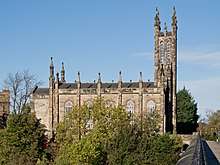 | |||
| Leith Docks, Paint Shed At Shipbuilding Yard | 55°58′49″N 3°10′33″W | Category B | 27071 | 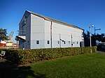 | |||
| 4 Ettrick Road | 55°56′00″N 3°13′14″W | Category C(S) | 27074 | | |||
| 10 And 12 Brighton Place | 55°57′09″N 3°06′55″W | Category B | 27077 | | |||
| Dalmahoy Estate, Dalmahoy Bridge Gogar Burn | 55°54′26″N 3°22′02″W | Category A | 26940 | | |||
| 18-22(Even Nos) Gray's Loan, Former Rudolf Steiner School | 55°55′48″N 3°13′29″W | Category B | 26954 |  | |||
| 30-36 Bernard Street | 55°58′34″N 3°10′06″W | Category B | 26959 | | |||
| 13A And 13B Chamberlain Road | 55°56′04″N 3°12′33″W | Category C(S) | 26972 | | |||
| Orwell Terrace, St Brides Community Centre (Former Parish Church And Hall) | 55°56′34″N 3°13′14″W | Category B | 26974 | | |||
| Dalmahoy Estate, St Mary's Episcopal Church | 55°54′26″N 3°22′07″W | Category B | 26987 | | |||
| 64 And 66 Colinton Road With Gates And Railings | 55°55′36″N 3°13′59″W | Category B | 26989 | | |||
| 11 Ladycroft, St Mungo's Episcopalian Church With Cottage And Boundary Wall And Gatepiers | 55°53′04″N 3°20′18″W | Category B | 26991 | | |||
| Gorgie Road, (At Tynecastle Lane), Railway Bridge | 55°56′19″N 3°13′46″W | Category B | 26997 |  | |||
| 6 John Street | 55°57′07″N 3°06′17″W | Category B | 27000 | | |||
| 50-58 (Even Nos) Bernard Street And 35 Shore | 55°58′35″N 3°10′09″W | Category B | 27005 | 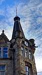 | |||
| Dalmahoy Home Farm And Stables | 55°54′21″N 3°21′55″W | Category C(S) | 27010 | | |||
| 1 Joppa Pans, (Rock Cottage) | 55°56′55″N 3°05′18″W | Category B | 27011 | | |||
| 527, Lanark Road West, Ravelrig Estate, Dovecot | 55°53′09″N 3°20′39″W | Category A | 27014 | | |||
| 46-56 (Even Nos) Bath Street (Brighton Mansions) | 55°57′17″N 3°06′40″W | Category B | 26896 | | |||
| Haymarket Terrace, Haymarket Station Entrance And Office Block With Steps, Railings, And Lamp Standard | 55°56′44″N 3°13′06″W | Category A | 26901 | 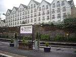 | |||
| 26 Colinton Road | 55°55′53″N 3°13′11″W | Category C(S) | 26917 | | |||
| 15-23 (Odd Nos) Bernard Street And 26 Maritime Street | 55°58′32″N 3°10′03″W | Category B | 26796 | | |||
| 13 Braid Road, Braidfoot | 55°55′25″N 3°12′33″W | Category C(S) | 26797 | | |||
| Dalry Road, St Martin Of Tours (Episcopal) With Boundary Walls | 55°56′25″N 3°13′31″W | Category B | 26799 |  | |||
| 97 Slateford Road And 11 To 15 Hermand Street, St Stephen's Works Waddie & Co Ltd | 55°56′00″N 3°14′03″W | Category C(S) | 26808 | | |||
| 1-12 (Inclusive Nos) Commercial Street And 26-43 (Inclusive Nos) Sandport Street (And Commercial Wharf); Eh6 6Ja And Eh6 6Ep Respectively | 55°58′35″N 3°10′19″W | Category B | 26812 | | |||
| 69B Braid Road Hermitage Of Braid Lodge | 55°55′10″N 3°12′36″W | Category C(S) | 26822 |  | |||
| Canongate Parish Church Including Burial Ground, Gates, Gatepiers, Boundary Walls And Railings | 55°57′06″N 3°10′46″W | Category A | 26823 |  | |||
| 3 Gladstone Place With Boundary Wall | 55°58′11″N 3°09′34″W | Category C(S) | 26829 | | |||
| 185-193 (Odd Nos) Leith Walk | 55°58′02″N 3°10′28″W | Category B | 26832 | | |||
| 258-266 (Even Nos) Gorgie Road And Link To Smithfield Street | 55°56′14″N 3°14′08″W | Category C(S) | 26851 | | |||
| 31 Bellfield Street | 55°57′08″N 3°06′27″W | Category A | 26749 | | |||
| 176-196 Even Nos Bruntsfield Place | 55°56′10″N 3°12′35″W | Category C(S) | 26750 | | |||
| 22 Braid Avenue And 9A Hermitage Drive With Carriage House, Boundary Walls And Gatepiers | 55°55′17″N 3°12′18″W | Category B | 26757 | | |||
| Ashley House With Orangery | 55°55′40″N 3°21′28″W | Category B | 26761 | | |||
| 8 And 9 Claremont Park With Boundary Wall, Gatepiers And Lamp Brackets | 55°58′11″N 3°09′18″W | Category B | 26764 | | |||
| Bernard Street, Robert Burns Statue | 55°58′31″N 3°10′00″W | Category B | 26769 | | |||
| 33 And 35 Broughton Place, Formerly Broughton Place Church And Offices | 55°57′33″N 3°11′14″W | Category A | 26771 |  | |||
| Ashley House Lodge With Boundary Walls And Gatepiers | 55°55′51″N 3°21′33″W | Category C(S) | 26775 | | |||
| 212-226 Even Nos Bruntsfield Place | 55°56′07″N 3°12′38″W | Category B | 26790 | | |||
| 2 And 3 Claremont Park With Boundary Walls, Gatepiers And Lamp Brackets | 55°58′11″N 3°09′28″W | Category B | 26700 | | |||
| 14 And 16 Abbotsford Park With Boundary Wall | 55°55′54″N 3°12′41″W | Category B | 26719 | | |||
| 5 And 7 Bath Street | 55°57′11″N 3°06′49″W | Category C(S) | 26728 | | |||
| Dalry Road, Dalry Cemetery, Gatepiers, Boundary Walls And Railings | 55°56′24″N 3°13′27″W | Category C(S) | 26733 | | |||
| 11 Drum Terrace, Eastern Cemetery, The Lodge, Gates, Railings And Gate Piers | 55°57′45″N 3°10′12″W | Category B | 26742 | | |||
| Gorgie Road And Ardmillan Terrace Springwell House With Gatepiers Boundary Walls And Railings | 55°56′20″N 3°13′38″W | Category C(S) | 26743 | | |||
| Dalmeny Village, Main Street, Gospatric House, Including Terrace Walls, Garden Walls And Gatepiers | 55°58′59″N 3°22′24″W | Category C(S) | 5526 | | |||
| Dalmeny Village, 3 Wester Dalmeny | 55°58′57″N 3°22′26″W | Category C(S) | 5531 | | |||
| Dalmeny Village, 12 And 13 Main Street | 55°58′54″N 3°22′28″W | Category C(S) | 5541 | | |||
| Dalmeny House, Barnbougle Castle, Including Balustrade And Sundial | 55°59′31″N 3°20′06″W | Category A | 5548 |  | |||
| Braehead Mains, Statuary Group | 55°57′47″N 3°18′57″W | Category B | 5553 | | |||
| West Craigie Farmhouse, Including Gatepiers And Boundary Walls | 55°58′25″N 3°21′08″W | Category B | 5565 | | |||
| 7 Cramond Bridge, Cramond Bridge, Old Farmhouse | 55°57′52″N 3°19′05″W | Category C(S) | 5566 | | |||
| Dalmeny House, Barnbougle Gate Lodge, Including Gatepiers, Boundary Wall And Kennels | 55°58′50″N 3°20′53″W | Category B | 5501 | | |||
| Dalmeny House, East Craigie Gate Lodge, Including Boundary Wall And Gatepiers | 55°57′59″N 3°19′08″W | Category C(S) | 5504 | | |||
| Dalmeny House, 1, 2, 3, 4 Long Green | 55°59′00″N 3°19′13″W | Category B | 5508 | | |||
| Dalmeny House, Newhalls Gate Lodge | 55°59′20″N 3°22′29″W | Category C(S) | 5510 | | |||
| Dalmeny Station, Including Booking Office, Waiting Rooms, Canopy, Platforms And Fencing | 55°59′10″N 3°22′54″W | Category B | 5511 | | |||
| Dundas Castle, Including Stable Block | 55°58′31″N 3°24′52″W | Category A | 5512 |  | |||
| 372-376 (Even Nos) Leith Walk (Formerly 1-3 George Place), Including Boundary Walls | 55°57′48″N 3°10′44″W | Category B | 45803 | | |||
| 55 Buckstone Terrace, Fairmilehead Water Treatment Works, Filter House, Hillend Pump House And Entrance Gates And Boundary Wall | 55°54′14″N 3°12′19″W | Category B | 45834 | | |||
| 57 Oxgangs Road, Including Garage | 55°54′07″N 3°12′54″W | Category C(S) | 45840 | | |||
| 53 Pentland Terrace, Riselaw House | 55°54′43″N 3°12′44″W | Category B | 45841 | | |||
| 3 And 4 Swanston Village | 55°53′32″N 3°12′55″W | Category C(S) | 45843 | | |||
| 27-31 (Odd Nos) Broughton Place And 1 And 1A East Broughton Place | 55°57′32″N 3°11′15″W | Category B | 45927 | | |||
| 113 And 115 Broughton Street | 55°57′33″N 3°11′25″W | Category C(S) | 45935 | | |||
| 79-85 (Odd Nos) East Claremont Street | 55°57′46″N 3°11′31″W | Category A | 45941 | | |||
| 7-11 (Odd Nos) Forth Street | 55°57′27″N 3°11′16″W | Category B | 45946 | | |||
| 4 Lasswade Road | 55°54′47″N 3°09′35″W | Category C(S) | 45982 | | |||
| 24-30 (Even Nos) Dean Street, Former Secession Church And St Bernard's Church School | 55°57′30″N 3°12′40″W | Category C(S) | 46337 | | |||
| 1-11 (Inclusive Nos) Canning Street Lane And 2 Canning Street, Atholl House | 55°56′53″N 3°12′38″W | Category C(S) | 46521 | | |||
| Newhailes Policies, Wanton Walls Farmhouse And Steading | 55°56′14″N 3°05′11″W | Category C(S) | 46550 | | |||
| 16 And 18 Primrose Bank Road, With Boundary Walls And Gatepiers | 55°58′45″N 3°12′30″W | Category C(S) | 46742 | | |||
| 34 Primrose Bank Road, Craigallan, With Boundary Wall And Gatepiers | 55°58′46″N 3°12′35″W | Category B | 46744 | | |||
| 76 Trinity Road And 5 Spencer Place, Birnam Lodge, With Boundary Walls And Gatepiers | 55°58′36″N 3°12′23″W | Category C(S) | 46750 | | |||
| 110 And 112 Trinity Road And 21A Russell Place, With Porte Cochere, Boundary Walls And Gatepiers | 55°58′43″N 3°12′21″W | Category C(S) | 46752 | | |||
| 17 York Road, Provost's Lamp | 55°58′38″N 3°12′11″W | Category B | 46759 | | |||
| 65-67 (Odd Nos) Ravelston Dykes Road | 55°57′02″N 3°15′15″W | Category B | 46974 | | |||
| 1 And 2 Glengyle Terrace And 40-44 (Even Nos) Leven Street, Including Railings | 55°56′27″N 3°12′12″W | Category C(S) | 47028 | | |||
| 3-5 (Inclusive Nos) Glengyle Terrace Including Railings | 55°56′28″N 3°12′10″W | Category C(S) | 47029 | | |||
| 6-8 (Inclusive Nos) Glengyle Terrace, Including Railings | 55°56′28″N 3°12′09″W | Category C(S) | 47030 | | |||
| 12-14 (Inclusive Nos) Glengyle Terrace, Including Railings | 55°56′28″N 3°12′07″W | Category C(S) | 47032 | | |||
| 15-17 (Inclusive Nos) Glengyle Terrace, Including Railings | 55°56′28″N 3°12′05″W | Category C(S) | 47033 | | |||
| 59 Lauriston Place, Lauriston Church (Former United Presbyterian), Including Wall And Railings | 55°56′41″N 3°12′01″W | Category C(S) | 47035 | | |||
| 7, 8, 9, 16 And 17 Cramond Village | 55°58′47″N 3°18′01″W | Category B | 47284 | | |||
| 1-7 (Odd Nos) Spittal Street And 35 And 37 Bread Street | 55°56′46″N 3°12′14″W | Category B | 47578 | | |||
| Parkside Well-Head | 55°56′31″N 3°10′43″W | Category C(S) | 47585 | | |||
| 26-28 (Inclusive Nos) Castle Terrace, Including Boundary Wall And Railings | 55°56′50″N 3°12′11″W | Category A | 47853 | | |||
| 21-29 (Odd Nos) Grassmarket | 55°56′49″N 3°11′50″W | Category C(S) | 47868 | | |||
| 81 Grassmarket | 55°56′52″N 3°11′40″W | Category B | 47871 | | |||
| 1 Merchant Street | 55°56′51″N 3°11′33″W | Category B | 47895 | | |||
| 23-27 (Inclusive Nos) Greenside Place | 55°57′25″N 3°11′06″W | Category B | 48035 |  | |||
| 6 Davie Street, Former Heriot's School, Including Boundary Walls, Gates And Gatepiers | 55°56′43″N 3°10′57″W | Category B | 48083 | | |||
| 15-19 (Inclusive Nos) Bristo Place And 1-3 (Odd Nos) Teviot Place | 55°56′45″N 3°11′23″W | Category C(S) | 48212 | | |||
| Edinburgh Castle, National War Museum Of Scotland (Former Hospital And Ordnance Store), Including Sentry Boxes And Urns | 55°56′55″N 3°12′05″W | Category B | 48223 | | |||
| Edinburgh Castle, New Barracks | 55°56′54″N 3°12′05″W | Category A | 48224 | 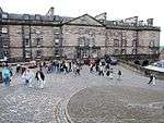 | |||
| Edinburgh Castle, Old Guardhouse, Including Inner Barrier | 55°56′56″N 3°11′57″W | Category B | 48225 | | |||
| Edinburgh Castle Esplanade, 72Nd Highlanders Memorial | 55°56′56″N 3°11′53″W | Category C(S) | 48237 | | |||
| 28-32 (Even Nos) Forrest Road And 19-22 (Inclusive Nos) Teviot Place | 55°56′42″N 3°14′20″W | Category C(S) | 48243 | | |||
| 503-509 (Odd Nos) Lawnmarket And 13-17A (Odd Nos) James Court | 55°56′58″N 3°11′39″W | Category B | 48245 | | |||
| Edinburgh Castle Esplanade, Monument To Colonel Mackenzie | 55°56′56″N 3°11′51″W | Category B | 48257 |  | |||
| 78-79 Angle Park Terrace (Former Fire Station) | 55°56′16″N 3°13′31″W | Category C(S) | 48283 | | |||
| Niddrie Mains Road, Thistle Foundation Estate, The Robin Chapel (Inter-Denominational) With Entrance Gates And Gatepiers | 55°55′53″N 3°07′50″W | Category A | 48686 | | |||
| 15 And 17 Kinellan Road, Including Boundary Walls | 55°56′56″N 3°14′59″W | Category C(S) | 48892 | | |||
| 8 Morningside Road, (Bank Of Scotland) Including Boundary Wall And Gatepiers | 55°56′03″N 3°12′38″W | Category B | 48939 | | |||
| 12 And 13 Earlston Place With Retaining Wall | 55°57′27″N 3°10′01″W | Category C(S) | 49052 | | |||
| 2 Easter Road, Techbase (Former Regent Road School) Including Boundary Walls, Railings And Outbuilding | 55°57′25″N 3°10′21″W | Category B | 49054 | | |||
| 1 And 3 Montrose Terrace, Stag And Turret Public House With Retaining Walls, Steps, Railings And Gate | 55°57′24″N 3°10′19″W | Category B | 49059 | 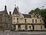 | |||
| 271 Canongate, Former Canongate United Presbyterian Church, Including Boundary Wall And Railings | 55°57′03″N 3°11′01″W | Category C(S) | 49077 | | |||
| 13 High Street, At Baron Maule's Close And Trunk's Close, Sandeman House, Including Landscaped Garden In Hope's Court | 55°57′04″N 3°11′07″W | Category C(S) | 49079 | | |||
| 21-23 (Inclusive Nos) Gayfield Square Including Railings | 55°57′35″N 3°11′07″W | Category B | 49148 | | |||
| 15 Union Street Including Railings And Boundary Wall | 55°57′29″N 3°11′09″W | Category B | 49153 | | |||
| 19-23 (Odd Numbers) Bonaly Road | 55°54′03″N 3°15′33″W | Category C(S) | 49547 | | |||
| Colinton Road, Merchiston Castle School, The Castle Gates, (Headmaster's House) | 55°54′39″N 3°15′16″W | Category C(S) | 49555 | | |||
| Colinton Road, Redford Infantry Barracks With Officers' Mess, Alma House, Guard House, Former Band Block, Former Sergeants' Mess, Gates, Gatepiers And Other Ancillary Buildings | 55°54′37″N 3°14′44″W | Category B | 49560 | 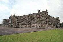 | |||
| Gillespie Road, Former Railway Bridge, Near Spylaw Farm | 55°54′23″N 3°16′07″W | Category C(S) | 49564 | | |||
| 7 Pentland Avenue With Boundary Wall, Steps And Garden Terrace | 55°54′30″N 3°15′40″W | Category B | 49565 | | |||
| 1 And 1B Thorburn Road, Lady Anderson Memorial Cottage | 55°54′30″N 3°15′08″W | Category C(S) | 49570 | | |||
| 15/1-4, 15/9-15, 15/17-22, 15/27-31 Thorburn Road, (All Inclusive Numbers) And 4 Redford Road, The Cottage Homes, With Sundial, Boundary Walls, Gates And Gatepiers | 55°54′29″N 3°15′06″W | Category C(S) | 49571 | | |||
| 4-9 (Inclusive Nos) Brunton Place Including Railings | 55°57′28″N 3°10′29″W | Category A | 49744 | | |||
| 5 Carlton Terrace Including Railings And Boundary Walls | 55°57′22″N 3°10′25″W | Category A | 49747 | | |||
| 15 Carlton Terrace Including Railings And Boundary Walls | 55°57′24″N 3°10′28″W | Category A | 49757 |  | |||
| 15 Regent Terrace, Including Railings And Boundary Walls | 55°57′17″N 3°10′36″W | Category A | 49778 |  | |||
| 32 Regent Terrace Including Railings And Boundary Walls | 55°57′20″N 3°10′29″W | Category A | 49797 |  | |||
| 23 Royal Terrace Including Railings And Boundary Walls | 55°57′24″N 3°10′40″W | Category A | 49814 | | |||
| 24 Royal Terrace Including Railings And Boundary Walls | 55°57′24″N 3°10′40″W | Category A | 49815 | | |||
| 27 Royal Terrace Including Railings And Boundary Walls | 55°57′24″N 3°10′38″W | Category A | 49818 | | |||
| 28 Royal Terrace Including Railings And Boundary Walls | 55°57′24″N 3°10′38″W | Category A | 49819 | | |||
| Pitsligo Road, Woodcroft Telephone Exchange Including Boundary Walls | 55°55′54″N 3°12′16″W | Category C(S) | 50035 | | |||
| South Queensferry, 1 And 2 Scotstoun House, Including Coachhouse And Garden Walls | 55°58′51″N 3°23′37″W | Category B | 50165 | | |||
| 18 Holyrood Park Road, University Of Edinburgh, Pollock Halls Of Residence Phases I And Ii: South Hall (Formerly Holland House, Fraser House And Refectory), Holland House (Blocks A, B, C And D) | 55°56′17″N 3°10′13″W | Category A | 50187 |  | |||
| 44 And 46 The Pleasance, University Of Edinburgh Centre For Sport And Exercise (Former Brewery And Offices) | 55°56′53″N 3°10′53″W | Category C(S) | 50193 | | |||
| Shore Road, Port Edgar, Capstan | 55°59′35″N 3°24′33″W | Category C(S) | 50854 | | |||
| 47-49 Lanark Road | 55°55′21″N 3°14′58″W | Category C(S) | 51159 | | |||
| 3 Drummond Street, Rutherford's Bar | 55°56′51″N 3°11′08″W | Category B | 51176 | | |||
| 1-7 (Odd Nos) Roxburgh Street, Including Railings | 55°56′52″N 3°10′59″W | Category C(S) | 51180 | | |||
| 87 Boswall Parkway, St Margaret Mary's Presbytery | 55°58′32″N 3°13′58″W | Category C(S) | 45648 | | |||
| 37 Granton Park Avenue, Former Madelvic Works, Office, Production Block, And Generating Block Only | 55°58′50″N 3°13′58″W | Category B | 45654 | | |||
| 14 Belford Mews | 55°57′06″N 3°13′11″W | Category B | 45580 | | |||
| Dundas Castle, Blue Acre, Including Boundary Wall | 55°58′35″N 3°24′58″W | Category C(S) | 45470 | | |||
| Dundas Castle, Castle Grove, Including Railings | 55°58′39″N 3°25′26″W | Category C(S) | 45473 | | |||
| Royal Circus Gardens, Railings And Gates, Including Lamps | 55°57′24″N 3°12′15″W | Category B | 45520 | | |||
| Craigiehall, Walled Garden, Including Gatepiers | 55°57′55″N 3°20′09″W | Category A | 45433 | | |||
| 70-76 (Even Nos) Grove Street | 55°56′36″N 3°12′41″W | Category C(S) | 44939 | |
Key
The scheme for classifying buildings in Scotland is:
- Category A: "buildings of national or international importance, either architectural or historic; or fine, little-altered examples of some particular period, style or building type."[1]
- Category B: "buildings of regional or more than local importance; or major examples of some particular period, style or building type, which may have been altered."[1]
- Category C: "buildings of local importance; lesser examples of any period, style, or building type, as originally constructed or moderately altered; and simple traditional buildings which group well with other listed buildings."[1]
In March 2016 there were 47,288 listed buildings in Scotland. Of these, 8 per cent were Category A, and 50 per cent were Category B, with the rest listed at Category C.[2]
Notes
- Sometimes known as OSGB36, the grid reference (where provided) is based on the British national grid reference system used by the Ordnance Survey.
• "Guide to National Grid". Ordnance Survey. Retrieved 12 December 2007.
• "Get-a-map". Ordnance Survey. Retrieved 17 December 2007. - Historic Environment Scotland assign a unique alphanumeric identifier to each designated site in Scotland, for listed buildings this always begins with "LB", for example "LB12345".
References
- All entries, addresses and coordinates are based on data from Historic Scotland. This data falls under the Open Government Licence
- "What is Listing?". Historic Environment Scotland. Retrieved 29 May 2018.
- Scotland's Historic Environment Audit 2016 (PDF). Historic Environment Scotland and the Built Environment Forum Scotland. pp. 15–16. Retrieved 29 May 2018.
This article is issued from Wikipedia. The text is licensed under Creative Commons - Attribution - Sharealike. Additional terms may apply for the media files.