List of listed buildings in Edinburgh/12
List
| Name | Location | Date Listed | Grid Ref. [note 1] | Geo-coordinates | Notes | LB Number [note 2] | Image |
|---|---|---|---|---|---|---|---|
| 17 Academy Street | 55°58′15″N 3°10′13″W | Category B | 26718 |  | |||
| 29 Caledonian Crescent, Dalry Public Baths, With Boundary Walls And Railings | 55°56′32″N 3°13′04″W | Category B | 26721 | | |||
| Ashley Terrace Lockhart Bridge | 55°55′53″N 3°13′37″W | Category B | 26730 | 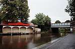 | |||
| 9 Bath Street | 55°57′11″N 3°06′48″W | Category B | 26741 | | |||
| 17-35 (Odd Nos) Braid Avenue | 55°55′34″N 3°12′13″W | Category C(S) | 26745 | | |||
| 18-25 (Inclusive Nos) Ardmillan Terrace And 60-64 (Even Nos) Angle Park Terrace | 55°56′16″N 3°13′34″W | Category B | 26695 |  | |||
| Bannerman And Cuthill, George Square, And 2 Causewayend | 56°32′44″N 3°16′07″W | Category C(S) | 23140 | | |||
| 253 High Street, 2 Warriston's Close And 14 Cockburn Street, City Chambers | 55°57′01″N 3°11′25″W | Category A | 17597 | 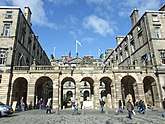 | |||
| Dalmeny Village, 3 And 4 Main Street | 55°58′55″N 3°22′20″W | Category B | 5533 | | |||
| Dalmeny House, Stable Block | 55°59′13″N 3°20′12″W | Category B | 5549 | | |||
| Craigiehall, Grotto | 55°57′47″N 3°19′50″W | Category C(S) | 5562 | | |||
| Craigiehall, Grotto Bridge | 55°57′46″N 3°19′47″W | Category B | 5563 | | |||
| 19 Cramond Brig Toll, Willowbank Cottage, Including Boundary Wall | 55°57′55″N 3°19′00″W | Category C(S) | 5568 | | |||
| Dalmeny House, Longcraig Gate Lodge | 55°59′36″N 3°22′24″W | Category C(S) | 5507 | | |||
| 114 And 116 Trinity Road, North Trinity House, With Boundary Walls And Gatepiers | 55°58′44″N 3°12′19″W | Category C(S) | 4445 | | |||
| 1 And 2 Swanston Village | 55°53′33″N 3°12′55″W | Category C(S) | 45842 | | |||
| 5 And 6 Swanston Village | 55°53′33″N 3°12′56″W | Category C(S) | 45844 | | |||
| 3 Bonnyhaugh Lane | 55°58′16″N 3°11′18″W | Category C(S) | 45922 | | |||
| 6 And 7 Bonnyhaugh Lane | 55°58′15″N 3°11′18″W | Category C(S) | 45924 | | |||
| 11-19 (Odd Nos) East London Street | 55°57′33″N 3°11′24″W | Category C(S) | 45943 | | |||
| 18 Forth Street | 55°57′29″N 3°11′14″W | Category B | 45951 | | |||
| 20 And 22 Forth Street | 55°57′29″N 3°11′13″W | Category B | 45952 | | |||
| 78-82 (Even Numbers) Portobello High Street, Former Shrub Mount | 55°57′16″N 3°07′00″W | Category C(S) | 46336 | | |||
| 231 Canongate, Old Sailor's Ark | 55°57′04″N 3°10′56″W | Category C(S) | 46707 | | |||
| 12 And 12A Laverockbank Road, Bankhead House, With Boundary Wall And Gatepiers | 55°58′42″N 3°12′02″W | Category C(S) | 46735 | | |||
| 102 Lower Granton Road, Wardie Hotel, With Yard Wall And Gatepiers | 55°58′48″N 3°12′58″W | Category C(S) | 46739 | | |||
| 26 York Road, Cairney House, With Boundary Wall And Gatepiers | 55°58′42″N 3°12′10″W | Category C(S) | 46765 | | |||
| 34 York Road, Lomond House, With Gateway And Boundary Walls | 55°58′44″N 3°12′11″W | Category C(S) | 46767 | | |||
| 26 Brougham Street, Former Parsonage House | 55°56′36″N 3°12′07″W | Category B | 47025 | | |||
| 77 Lauriston Place, With Boundary Wall And Railings | 55°56′40″N 3°12′02″W | Category C(S) | 47036 | | |||
| 125-165 (Odd Nos) Lothian Road, 6 And 8 Bread Street And 48 And 50 East Fountainbridge | 55°56′44″N 3°12′18″W | Category B | 47047 | 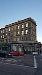 | |||
| 1 Gilmerton Road, Liberton Bank House | 55°55′32″N 3°09′59″W | Category C(S) | 47155 | | |||
| Horne Terrace Union Canal No 1 Viewforth Bridge | 55°56′26″N 3°12′48″W | Category B | 47615 | | |||
| Cammo Road, Cammo Estate, Knoll (Off Cammo Walk) | 55°57′11″N 3°19′17″W | Category B | 47715 |  | |||
| 33, 34 And 35 Castle Terrace, Including Boundary Wall And Railings | 55°56′49″N 3°12′10″W | Category A | 47856 |  | |||
| 27-41 (Odd Nos) Forrest Road | 55°56′46″N 3°11′31″W | Category C(S) | 47864 | | |||
| 43-49 (Odd Nos) Forrest Road | 55°56′44″N 3°11′30″W | Category C(S) | 47865 | | |||
| 28-32 (Even Nos) Keir Street, Including Boundary Wall And Railings | 55°56′43″N 3°11′50″W | Category B | 47882 | | |||
| King's Stables Road, St Cuthbert's Churchyard, Former Toolhouse | 55°56′55″N 3°12′14″W | Category C(S) | 47884 | | |||
| 47-55 (Odd Nos) Lothian Road | 55°56′52″N 3°12′21″W | Category B | 47893 |  | |||
| 85-93 (Odd Nos) Lothian Road | 55°56′48″N 3°12′20″W | Category C(S) | 47894 | | |||
| 17 And 19 Spittal Street And 2-6 (Even Nos) Grindlay Street | 55°56′47″N 3°12′12″W | Category C(S) | 47898 | | |||
| 3 Victoria Terrace, Baden-Powell House | 55°56′56″N 3°11′36″W | Category B | 47902 | | |||
| 8, 9 And 10 Bristo Place And 3 Bristo Port | 55°56′48″N 3°11′25″W | Category B | 48211 | .jpg) | |||
| Edinburgh Castle, Gatehouse | 55°56′55″N 3°11′55″W | Category A | 48218 | 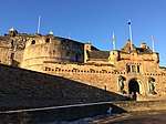 | |||
| Edinburgh Castle, Portcullis Gate And Argyle Tower | 55°56′56″N 3°11′59″W | Category A | 48227 | 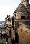 | |||
| Edinburgh Castle, St Margaret's Chapel | 55°56′55″N 3°12′00″W | Category A | 48228 | 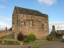 | |||
| 10-18 (Even Nos) Forrest Road, Oddfellows Hall | 55°56′45″N 3°11′27″W | Category B | 48241 |  | |||
| 7-10 (Inclusive Nos) Teviot Place | 55°56′44″N 3°11′25″W | Category C(S) | 48249 | | |||
| West Princes Street Gardens, Police Box | 55°57′01″N 3°12′19″W | Category B | 48252 |  | |||
| Sunbury Street, Belford Mews, Sunbury House, (Former Whytock And Reid Cabinet Makers) | 55°57′08″N 3°13′16″W | Category B | 48279 | | |||
| Summerhall, The Royal (Dick) School Of Veterinary Studies | 55°56′23″N 3°10′56″W | Category B | 48536 | | |||
| 2-8 (Even Nos) Coltbridge Terrace, Including Boundary Walls | 55°56′49″N 3°14′07″W | Category C(S) | 48884 | | |||
| Murrayfield Avenue, Police Box | 55°56′47″N 3°14′13″W | Category C(S) | 48898 | | |||
| 37 Ravelston Dykes Road, Wall Incorporating Old Fireplace (1 Of 2) | 55°57′09″N 3°15′22″W | Category B | 48906 | | |||
| Ravelston Dykes Road, Entrance Gateway And Adjoining Walls To East Of Nos 65-67 | 55°57′03″N 3°15′14″W | Category B | 48908 | | |||
| Craigs Bank, Craigsbank Parish Church (Church Of Scotland) With Hall (Including Former Church) | 55°56′37″N 3°17′49″W | Category A | 48977 | | |||
| 2 Piershill Terrace And 9-15 (Inclusive Numbers) Piershill Place | 55°57′18″N 3°08′49″W | Category C(S) | 49046 | | |||
| 5B Abbey Street, Abbeyhill Primary School, With Boundary Walls, Railings, Gatepiers And Janitor's House | 55°57′20″N 3°08′54″W | Category C(S) | 49049 | | |||
| 19 Abercorn Road, With Boundary Wall And Railings | 55°57′09″N 3°09′05″W | Category C(S) | 49050 | | |||
| 14 And 15 Earlston Place | 55°57′26″N 3°10′00″W | Category C(S) | 49053 | | |||
| 8-10 (Even Numbers) Easter Road | 55°57′28″N 3°10′18″W | Category C(S) | 49055 | | |||
| 35 London Road, Artisan Bar | 55°57′27″N 3°10′10″W | Category C(S) | 49057 | | |||
| 249-263 (Odd Nos) Canongate, And 43 New Street, Morocco Land Redevelopment | 55°57′03″N 3°10′59″W | Category B | 49076 | | |||
| 11-14 (Inclusive Nos) Antigua Street | 55°57′29″N 3°11′06″W | Category B | 49145 | | |||
| 10 Gayfield Square Including Railings | 55°57′34″N 3°11′13″W | Category B | 49147 | | |||
| 20A Inverleith Row Including Laboratories, Lecture Hall, Classrooms And Offices | 55°58′00″N 3°12′20″W | Category B | 49213 | | |||
| Royal Botanic Garden, Inverleith Row, 1967 Greenhouse | 55°57′59″N 3°12′29″W | Category A | 49216 | 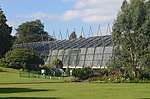 | |||
| 4 And 8 Gilmerton Road, Cottages At Good's Corner Including Boundary Wall | 55°55′26″N 3°09′59″W | Category C(S) | 49359 | | |||
| 545 Old Dalkeith Road, Edmonstone House South Gates And Lodge | 55°54′48″N 3°07′30″W | Category B | 49518 | | |||
| Kinnear Road, Mackenzie House With Boundary Wall | 55°58′05″N 3°13′00″W | Category B | 49545 | | |||
| Bridge Road, K6 Telephone Kiosk At Junction With Spylaw Street | 55°54′26″N 3°15′32″W | Category B | 49554 | | |||
| 18 Spylaw Bank Road, Hailes Brae, With Boundary Wall And Garage | 55°54′35″N 3°15′31″W | Category C(S) | 49567 | | |||
| 10-20 (Even Nos) Restalrig Drive, Former Kinloch Anderson Factory | 55°57′35″N 3°08′58″W | Category C(S) | 49596 | | |||
| Fettes College, North Lodge, Gates, Gatepiers And Railings | 55°58′01″N 3°13′31″W | Category B | 49629 | | |||
| 13 Carlton Terrace Including Railings And Boundary Walls | 55°57′24″N 3°10′27″W | Category A | 49755 |  | |||
| 16 Carlton Terrace Including Railings And Boundary Walls | 55°57′24″N 3°10′28″W | Category A | 49758 |  | |||
| 6 Regent Terrace Including Railings And Boundary Walls | 55°57′16″N 3°10′40″W | Category A | 49769 |  | |||
| 8 Royal Terrace Including Railings And Boundary Walls | 55°57′24″N 3°10′48″W | Category A | 49806 | | |||
| 31 Royal Terrace Including Railings And Boundary Walls | 55°57′24″N 3°10′36″W | Category A | 49823 | | |||
| 32 Royal Terrace Including Railings And Boundary Walls | 55°57′24″N 3°10′36″W | Category A | 49824 |  | |||
| 33 Royal Terrace Including Railings And Boundary Walls | 55°57′24″N 3°10′35″W | Category A | 49825 |  | |||
| 36 Royal Terrace Including Railings And Boundary Walls | 55°57′24″N 3°10′33″W | Category A | 49828 |  | |||
| 10A Greenhill Park Including Garage, Pillar, Gates And Railings | 55°56′00″N 3°12′25″W | Category B | 49879 | | |||
| 62-66 (Even Nos) Warrender Park Road | 55°56′17″N 3°11′43″W | Category C(S) | 49895 | | |||
| 1 And 5 Main Street, Balerno, Dean Park Primary School Annexe | 55°53′05″N 3°20′22″W | Category C(S) | 49896 | | |||
| 1-21 (Odd Nos) Queen Charlotte Street And 1, 2 Maritime Street And 46 Water Street | 55°58′27″N 3°10′09″W | Category B | 49897 | | |||
| 47 And 48 Greenbank Drive | 55°55′00″N 3°13′21″W | Category C(S) | 48389 | | |||
| Regent Road, K6 Telephone Kiosk | 55°57′14″N 3°10′57″W | Category B | 49151 | .jpg) | |||
| Lanark Road West, Currie Library And Curriehill Primary School Including Boundary Walls And Railings | 55°53′47″N 3°18′41″W | Category C(S) | 50143 | | |||
| 48 The Pleasance, University Of Edinburgh, Sports Union | 55°56′53″N 3°10′55″W | Category B | 50194 | | |||
| Glenogle Road, Glenogle Park (The Colonies), 1-8 (Inclusive) Glenogle House | 55°57′43″N 3°12′23″W | Category B | 50520 | | |||
| Glenogle Road, Glenogle Park (The Colonies), 1-8 (Inclusive) Glenogle Terrace | 55°57′44″N 3°12′23″W | Category B | 50522 | | |||
| Glenogle Road, Glenogle Park (The Colonies), 1-32 (Inclusive) Rintoul Place | 55°57′40″N 3°12′37″W | Category B | 50526 | | |||
| Shore Road, Port Edgar, East And West Breakwaters | 55°59′50″N 3°24′48″W | Category C(S) | 50855 | | |||
| Comiston Springs (Hare, Moubray, Fox, Sandglass And Peewit) Comiston Springs Avenue, Comiston View, Pentland Gardens, Oxgangs Loan And Oxgangs Green | 55°54′41″N 3°12′56″W | Category B | 27964 | | |||
| 51, 51A Lanark Road, Former Chalmers Memorial Hall | 55°55′20″N 3°14′59″W | Category C(S) | 51269 | | |||
| 23 Inverleith Terrace, St Colm's College Including Boundary Walls And Cast Iron Railing Panels | 55°57′47″N 3°12′21″W | Category B | 51308 | | |||
| 1-8 (Inclusive Numbers) Rothesay Mews | 55°57′03″N 3°13′10″W | Category C(S) | 51341 | | |||
| 1-9 (Inclusive Numbers) Ravelston Terrace | 55°57′11″N 3°13′31″W | Category C(S) | 51395 | | |||
| Mayfield Road, Edinburgh University Kings Buildings, Hudson Beare Lecture Theatre, Department Of Engineering, Including Hard Landscaping And Retaining Boundary Walls | 55°55′21″N 3°10′15″W | Category B | 51407 | | |||
| Chambers Street, Lamp Standard | 55°56′53″N 3°11′12″W | Category B | 51549 |  | |||
| 23 Union Street, Edinburgh Printmakers | 55°57′30″N 3°11′11″W | Category C(S) | 51647 | | |||
| 2 Lufra Bank, Off Granton View, Lufra Cottage Including Walled Yard To S | 55°58′44″N 3°13′07″W | Category C(S) | 45658 | | |||
| Dundas Castle, South Lodge, Including Gates, Gatepiers And Walls | 55°57′58″N 3°24′09″W | Category B | 45476 | | |||
| West Scotland Street Lane | 55°57′34″N 3°11′45″W | Category B | 45526 | | |||
| Dalmeny House, Leuchold, Including Boundary Wall And Outbuildings | 55°59′37″N 3°21′48″W | Category B | 45438 | | |||
| 1,2 Gladstone Place And 1,3 Restalrig Road With Railings | 55°58′11″N 3°09′35″W | Category C(S) | 44904 | | |||
| 21 And 23 Leven Street | 55°56′29″N 3°12′13″W | Category B | 44943 | | |||
| Seafield Street, Eastern General Hospital, Chapel | 55°58′07″N 3°08′44″W | Category C(S) | 44951 | | |||
| 134 Corstorphine Road, Edinburgh Zoo (Royal Zoological Society Of Scotland) Members House Including Sundial | 55°56′39″N 3°16′12″W | Category B | 44750 | .jpg) | |||
| 2 Dovecot Road, Dovecot Studios Of The Edinburgh Tapestry Company | 55°56′21″N 3°16′55″W | Category C(S) | 44763 | | |||
| Mcdonald Road, Former Generating Station Including Offices, Stack And Former Printing Works | 55°57′52″N 3°11′07″W | Category B | 44782 | | |||
| 392 Gorgie Road And 7 And 9 Alexander Drive, Former Roxy Cinema | 55°56′10″N 3°14′29″W | Category C(S) | 44618 | | |||
| 8-11 (Inclusive Nos) Ventnor Terrace, Including Boundary Walls | 55°55′56″N 3°10′10″W | Category C(S) | 44437 | | |||
| 18 West Savile Road, Tarquin House, Including Boundary Walls And Railings | 55°55′45″N 3°10′30″W | Category B | 44442 | | |||
| 1 Blacket Place, Including Former Carriage House And Boundary Walls | 55°56′15″N 3°10′21″W | Category B | 44199 | | |||
| 31 And 33 Blacket Place, Including Boundary Walls | 55°56′07″N 3°10′23″W | Category C(S) | 44201 | | |||
| 20 Gilmerton Road, Dovecot Cottage | 55°55′22″N 3°09′53″W | Category C(S) | 44215 | | |||
| 7 And 8 Gilmour Road, Including Boundary Walls | 55°55′46″N 3°10′17″W | Category C(S) | 44216 | | |||
| 12 And 14 Mayfield Terrace, Including Boundary Walls | 55°56′05″N 3°10′21″W | Category C(S) | 44235 | | |||
| Torphichen Street, Former Torphichen Street Education Centre, Including Janitor's House, Gates, Gatepiers, Boundary Walls And Railings | 55°56′50″N 3°12′45″W | Category B | 43888 | | |||
| 4 And 4B Barnton Avenue West, Including Boundary Railings And Gatepiers | 55°57′59″N 3°18′19″W | Category C(S) | 43930 | | |||
| 10 And 12 Brae Park Road, Including Boundary Wall | 55°57′57″N 3°18′52″W | Category C(S) | 43932 | | |||
| Cammo Road, Cammo Estate, Gate Lodge | 55°57′35″N 3°19′09″W | Category B | 43936 | | |||
| 2 Great Michael Rise And 29, 30 And 33 Annfield | 55°58′48″N 3°11′30″W | Category B | 43699 | | |||
| 16, 18 And 20 Newhaven Main Street | 55°58′49″N 3°11′37″W | Category C(S) | 43705 | | |||
| 216 And 218 Newhaven Road And 55 Hawthornvale, Including Boundary Wall | 55°58′42″N 3°11′35″W | Category C(S) | 43717 | | |||
| 12 Pier Place And 56 And 58 Newhaven Main Street | 55°58′50″N 3°11′49″W | Category C(S) | 43723 | | |||
| Pier Place, Police Box | 55°58′51″N 3°11′42″W | Category B | 43726 | | |||
| Queen Street Central Gardens, Doric Pavilion | 55°57′19″N 3°11′55″W | Category A | 43498 |  | |||
| 11 And 13 Hill Street | 55°57′13″N 3°12′08″W | Category A | 43297 | | |||
| 10 Hill Street | 55°57′12″N 3°12′07″W | Category A | 43300 | | |||
| 12 Hill Street | 55°57′12″N 3°12′08″W | Category A | 43301 | | |||
| 72 And 73 Princes Street | 55°57′09″N 3°11′46″W | Category B | 43317 | | |||
| 133 Rose Street | 55°57′06″N 3°12′14″W | Category C(S) | 43332 | | |||
| 163-167 (Odd Nos) Rose Street | 55°57′05″N 3°12′19″W | Category B | 43335 |  | |||
| 184-188 (Even Nos) Rose Street | 55°57′05″N 3°12′16″W | Category B | 43342 | | |||
| 47 Thistle Street And 19 North West Thistle Street Lane | 55°57′15″N 3°11′57″W | Category B | 43358 | | |||
| 54-58 Thistle Street With Warehouses In Sw Thistle Street Lane | 55°57′14″N 3°11′58″W | Category B | 43364 | | |||
| Frogston Road East, Mortonhall House, Walled Garden | 55°54′12″N 3°11′12″W | Category C(S) | 43240 | | |||
| 280 Gilmerton Road, Liberton Northfield Parish Church And Halls, Walls And Gatepiers | 55°55′02″N 3°09′12″W | Category B | 43241 | | |||
| Gilmerton, 4B Drum Street, Community Centre, With Boundary Walls And Railings | 55°54′21″N 3°08′03″W | Category B | 43255 | | |||
| Gilmerton, Ferniehill Drive, The Drum, North Gatepiers | 55°54′37″N 3°07′33″W | Category B | 43258 | | |||
| 27 George Street | 55°57′14″N 3°11′49″W | Category B | 43286 | | |||
| 21-25 (Odd Nos) Causewayside | 55°56′19″N 3°10′53″W | Category B | 43143 |  | |||
| 169-179 (Odd Nos) Causewayside, Wight's Place | 55°56′09″N 3°10′47″W | Category B | 43146 | | |||
| 75-77 (Inclusive Nos) Dalkeith Road | 55°56′14″N 3°10′14″W | Category C(S) | 43149 | | |||
| 44 Minto Street Including Gatepiers And Boundary Walls | 55°56′11″N 3°10′38″W | Category C(S) | 43159 | | |||
| 13, Priestfield Road | 55°56′10″N 3°09′58″W | Category C(S) | 43166 | |
Key
The scheme for classifying buildings in Scotland is:
- Category A: "buildings of national or international importance, either architectural or historic; or fine, little-altered examples of some particular period, style or building type."[1]
- Category B: "buildings of regional or more than local importance; or major examples of some particular period, style or building type, which may have been altered."[1]
- Category C: "buildings of local importance; lesser examples of any period, style, or building type, as originally constructed or moderately altered; and simple traditional buildings which group well with other listed buildings."[1]
In March 2016 there were 47,288 listed buildings in Scotland. Of these, 8 per cent were Category A, and 50 per cent were Category B, with the rest listed at Category C.[2]
Notes
- Sometimes known as OSGB36, the grid reference (where provided) is based on the British national grid reference system used by the Ordnance Survey.
• "Guide to National Grid". Ordnance Survey. Retrieved 12 December 2007.
• "Get-a-map". Ordnance Survey. Retrieved 17 December 2007. - Historic Environment Scotland assign a unique alphanumeric identifier to each designated site in Scotland, for listed buildings this always begins with "LB", for example "LB12345".
References
- All entries, addresses and coordinates are based on data from Historic Scotland. This data falls under the Open Government Licence
- "What is Listing?". Historic Environment Scotland. Retrieved 29 May 2018.
- Scotland's Historic Environment Audit 2016 (PDF). Historic Environment Scotland and the Built Environment Forum Scotland. pp. 15–16. Retrieved 29 May 2018.
This article is issued from Wikipedia. The text is licensed under Creative Commons - Attribution - Sharealike. Additional terms may apply for the media files.