List of listed buildings in Edinburgh/1
List
| Name | Location | Date Listed | Grid Ref. [note 1] | Geo-coordinates | Notes | LB Number [note 2] | Image |
|---|---|---|---|---|---|---|---|
| Kirkliston Village Newliston Road, Former Kirkliston Distillery, Production Block Including Malt Barns And Double Kiln And Separate Still House | 55°57′11″N 3°24′27″W | Category C(S) | 45644 |  | |||
| 55/55A Boswall Parkway, Granton Parish Church And Church Hall, Including War Memorial | 55°58′35″N 3°13′27″W | Category B | 45645 | | |||
| 61 Boswall Parkway, Granton Congregational Church | 55°58′34″N 3°13′40″W | Category C(S) | 45646 | | |||
| 8 Granton Square, Former Granton Hotel And Hms Claverhouse, Including Lamp Standards | 55°58′50″N 3°13′25″W | Category B | 45655 | | |||
| 20 West Harbour Road, Including Rear Outbuildings | 55°58′55″N 3°13′43″W | Category C(S) | 45659 | | |||
| 2 Seafield Street, Filliside House With Boundary Walls | 55°58′08″N 3°08′46″W | Category B | 45576 | | |||
| Dundas Castle, Brown Acre, Lilac Cottage, Rose Cottage And Dundas Mains, Including Railings, Gates And Wall | 55°58′40″N 3°25′31″W | Category B | 45472 | | |||
| Circus Lane, Nos 3-15 (Odd Nos), 19-57 (Odd Nos) And Nos 6-10 (Even Nos), Including Walls | 55°57′28″N 3°12′22″W | Category B | 45477 | | |||
| 1 Northumberland Place | 55°57′26″N 3°11′44″W | Category B | 45518 | | |||
| 13 St Vincent Street, St Vincent Church (Episcopal), Including Gatepiers And Railings | 55°57′30″N 3°12′14″W | Category B | 45522 | 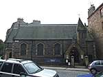 | |||
| Bankhead, 3 Bankhead Cottages | 55°59′11″N 3°22′35″W | Category C(S) | 45431 | | |||
| 2-12 (Even Nos) Torphichen Street, Including Railings | 55°56′49″N 3°12′53″W | Category B | 44923 | | |||
| 41-45 (Odd Nos) Gilmore Place, Little Sisters Of The Poor /St Joseph's Nursing Home, Including Boundary Walls, Gatepiers And Gates | 55°56′29″N 3°12′24″W | Category C(S) | 44937 | | |||
| 114-116 St John's Road, Harp Hotel Including Boundary Walls, Gatepiers And Gates | 55°56′35″N 3°17′02″W | Category C(S) | 44757 | | |||
| 20 And 20A West Mayfield, Mayfield House Including Boundary Walls, Gatepiers And Pedestrian Gates | 55°56′00″N 3°10′34″W | Category C(S) | 44440 | | |||
| West Savile Road And Craigmillar Park, Royal Blind School, Including Boundary Walls And Gate Lodge | 55°55′52″N 3°10′19″W | Category C(S) | 44443 | | |||
| 5 Blacket Avenue, Belleville Lodge, Including Gatepiers, Boundary Walls, Pedestrian And Carriage Gates | 55°56′12″N 3°10′26″W | Category C(S) | 44189 | | |||
| 27 And 29 Blacket Place, Including Boundary Walls | 55°56′07″N 3°10′23″W | Category C(S) | 44200 | | |||
| 60 And 62 Blacket Place, Including Boundary Walls | 55°56′07″N 3°10′26″W | Category C(S) | 44203 | | |||
| 6, 6A, 6B And 8 Craigmillar Park, Belmont House, Including Gatepiers And Boundary Walls | 55°55′48″N 3°10′16″W | Category B | 44207 | | |||
| Craigmillar Park, Craigmillar Park Church Including War Memorial, Gatepiers And Boundary Walls | 55°55′51″N 3°10′18″W | Category B | 44210 | | |||
| 1-5 (Inclusive Nos) Gordon Terrace, Including Boundary Walls | 55°55′32″N 3°10′03″W | Category C(S) | 44217 | | |||
| 10 And 12 Lygon Road, Including Boundary Walls | 55°55′35″N 3°10′10″W | Category C(S) | 44224 | | |||
| 2-28 (Even Nos) Moston Terrace And 13 Bright's Crescent, Including Boundary Walls And Pedestrian Gate | 55°55′55″N 3°10′33″W | Category C(S) | 44248 | | |||
| Observatory Road, Blackford Hill, The Royal Observatory, Astronomer's House | 55°55′22″N 3°11′18″W | Category B | 44249 | | |||
| 37 Barnton Avenue West And Gamekeeper's Road, Cargilfield School, Including Chapel, Nursery, Cricket Pavilion, Boundary Walls, Gatepiers And Gates | 55°58′10″N 3°18′09″W | Category B | 43929 | | |||
| 188 And 190 Ferry Road Including Boundary Walls | 55°58′26″N 3°11′25″W | Category C(S) | 43693 | | |||
| 4-12 (Even Nos) Great Michael Rise | 55°58′47″N 3°11′33″W | Category B | 43700 | | |||
| 1-8 Industry Homes, Industry Lane | 55°58′31″N 3°11′05″W | Category C(S) | 43702 | | |||
| 2-16 (Even Nos) New Lane, Newhaven | 55°58′47″N 3°11′28″W | Category B | 43711 | | |||
| Newhaven, Old Harbour Light | 55°58′56″N 3°11′45″W | Category B | 43713 | | |||
| 148 Newhaven Road, Including Boundary Wall | 55°58′33″N 3°11′28″W | Category C(S) | 43715 | | |||
| 8, 9, 10 Pier Place, Former St Andrew's Free Church And Halls | 55°58′50″N 3°11′47″W | Category B | 43724 | | |||
| 14 And 16 Hill Street | 55°57′12″N 3°12′09″W | Category A | 43302 | | |||
| 118 Princes Street And 2 Castle Street | 55°57′04″N 3°12′11″W | Category B | 43325 | | |||
| 119, 119A And 120 Princes Street | 55°57′04″N 3°12′12″W | Category B | 43326 | | |||
| Rose Street, Eagle Buildings | 55°57′11″N 3°11′45″W | Category B | 43330 | | |||
| 133A To 137 (Odd Nos) Rose Street And 101 And 103 Rose Street North Lane | 55°57′06″N 3°12′15″W | Category B | 43333 | | |||
| 32 Rose Street | 55°57′10″N 3°11′47″W | Category C(S) | 43336 | | |||
| 108 Rose Street | 55°57′08″N 3°12′02″W | Category C(S) | 43338 | | |||
| 35-39 (Odd Nos) Thistle Street With Boundary Wall To Rear | 55°57′15″N 3°11′56″W | Category B | 43356 | | |||
| 16 Young Street | 55°57′10″N 3°12′20″W | Category A | 43367 | | |||
| 55 And 57 Frogston Road East, Mortonhall House, Former Kennels | 55°54′09″N 3°11′10″W | Category C(S) | 43239 | | |||
| 30B Howdenhall Road, Mortonhall Crematorium With Remembrance Chapel, Waiting Room, Lodge Houses And Screen Walls | 55°54′09″N 3°10′13″W | Category A | 43242 | | |||
| 75 Kirkbrae, Mount Pleasant With Gatepiers, Garden Walls, Greenhouse And Summerhouse | 55°54′54″N 3°09′39″W | Category B | 43243 | | |||
| 77 Kirkbrae, Covington With Gatepiers, Garden Walls And Greenhouse | 55°54′53″N 3°09′40″W | Category C(S) | 43244 | | |||
| 81 Kirk Brae,St Hilda's | 55°54′50″N 3°09′36″W | Category C(S) | 43249 | | |||
| Lasswade Road, 1-16 (Inclusive Nos) Lockerby Cottages With Screen Walls, Gatepiers, Garden Walls And Railings | 55°54′19″N 3°09′01″W | Category B | 43263 | | |||
| 13A George Street, Known As Crippled Aid Building | 55°57′15″N 3°11′45″W | Category C(S) | 43285 | | |||
| 21 Dalkeith Road And Holyrood Park Road, Royal Commonwealth Pool | 55°56′21″N 3°10′22″W | Category A | 43148 | 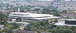 | |||
| 8 And 12-20 (Even Nos) Newington Road | 55°56′19″N 3°10′46″W | Category C(S) | 43161 | | |||
| 22-30 (Even Nos) Newington Road | 55°56′18″N 3°10′45″W | Category C(S) | 43162 | | |||
| 32 And 33 High Street | 55°59′24″N 3°23′44″W | Category B | 40381 | | |||
| 6 Mid Terrace | 55°59′24″N 3°23′45″W | Category C(S) | 40398 | | |||
| High Street (In Front Of Tolbooth), K6 Telephone Kiosk | 55°59′25″N 3°23′49″W | Category B | 40413 | | |||
| 37 Station Road, Ashburnham Lodge | 55°59′15″N 3°23′13″W | Category C(S) | 40415 | | |||
| 12 East Terrace, St. Helen's | 55°59′22″N 3°23′38″W | Category B | 40342 | | |||
| 18 East Terrace | 55°59′23″N 3°23′41″W | Category B | 40347 | | |||
| 8-16 (Inclusive Numbers) Echline | 55°59′07″N 3°25′02″W | Category B | 40352 | | |||
| 9 Edinburgh Road And Boundary Walls | 55°59′24″N 3°23′33″W | Category B | 40361 | | |||
| 4 And 6 Edinburgh Road | 55°59′23″N 3°23′34″W | Category C(S) | 40363 | | |||
| 171 Whitehouse Loan Sidney Lodge Including Stables, Gatepiers And Boundary Walls | 55°55′53″N 3°11′58″W | Category B | 30669 | | |||
| 3 Whitehouse Terrace Braemar House Including Gatepiers And Boundary Walls | 55°55′54″N 3°11′52″W | Category B | 30673 | | |||
| 8 Whitehouse Terrace "Ainslie Grange" Hotel Including Lodge, Gatepiers And Boundary Walls | 55°55′52″N 3°11′39″W | Category B | 30677 | | |||
| 36 (Formerly 4) South Oswald Road | 55°55′44″N 3°11′36″W | Category B | 30593 | | |||
| 12-19 (Inclusive Nos) Strathearn Road | 55°56′03″N 3°11′45″W | Category B | 30603 | | |||
| 3-17 (Inclusive Nos) Thirlestane Lane Mews | 55°56′06″N 3°11′44″W | Category C(S) | 30606 | | |||
| 35-37 (Odd Nos) Warrender Park Rd & 27 27A 27B 27C Marchmont Road | 55°56′19″N 3°11′41″W | Category B | 30617 |  | |||
| 39-43 (Odd Nos) Warrender Park Rd & 22-30 Marchmont Rd | 55°56′18″N 3°11′42″W | Category B | 30618 | 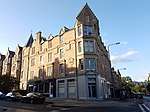 | |||
| 42-46 (Even Nos) Warrender Park Road | 55°56′17″N 3°11′39″W | Category C(S) | 30642 | | |||
| 20-22 (Incl Nos) Warrender Park Terrace Incl Railings | 55°56′21″N 3°11′51″W | Category B | 30651 | | |||
| 23 Warrender Park Terrace And 2 & 4 Spottiswoode Street | 55°56′21″N 3°11′52″W | Category B | 30652 | | |||
| 30-32 (Inclusive Nos) Warrender Park Terrace | 55°56′20″N 3°11′56″W | Category B | 30655 | | |||
| 113 Whitehouse Loan Gillis College Rc Chapel | 55°56′05″N 3°12′02″W | Category A | 30664 | | |||
| 1-21 (Inclusive Nos) Greenhill Place | 55°56′02″N 3°12′13″W | Category B | 30522 | | |||
| 1-12 Greenhill Terrace Gates Gatepiers And Boundary Wall | 55°56′08″N 3°12′11″W | Category C(S) | 30523 | | |||
| 57 Lauderdale Street, James Gillespie's High School, Bruntsfield House Including Gateways And Boundary Walls | 55°56′12″N 3°11′58″W | Category A | 30530 | | |||
| 31 Marchmont Crescent | 55°56′16″N 3°11′37″W | Category B | 30532 | | |||
| 23 Marchmont Road | 55°56′20″N 3°11′41″W | Category B | 30543 | | |||
| 55 Marchmont Road | 55°56′15″N 3°11′39″W | Category B | 30548 | | |||
| 2 Marchmont Road And 1 Warrender Park Terrace | 55°56′22″N 3°11′44″W | Category B | 30551 | | |||
| 10 And 12 Marchmont Road | 55°56′21″N 3°11′44″W | Category B | 30553 | | |||
| 12 And 13 Marchmont Street | 55°56′19″N 3°12′01″W | Category B | 30575 | | |||
| 123-129 (Odd Nos) Marchmont Road And 7-10 (Inclusive Nos) Beaufort Road | 55°56′06″N 3°11′38″W | Category B | 30450 | 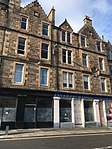 | |||
| 1-8 (Inclusive Nos) Meadow Place And 4, 8, 9, 10, 11, 12, Roseneath Place Including Boundary Walls | 55°56′22″N 3°11′37″W | Category B | 30452 | | |||
| 1-10 (Inclusive Nos) Millerfield Place | 55°56′22″N 3°11′16″W | Category B | 30454 | | |||
| 2 Palmerston Road Including Boundary Walls | 55°56′10″N 3°11′32″W | Category B | 30459 | | |||
| 1A And 1-9 (Inclusive Nos) Rillbank Terrace | 55°56′20″N 3°11′20″W | Category B | 30462 | | |||
| 11-15 (Odd Nos) Roseneath Terrace | 55°56′21″N 3°11′33″W | Category B | 30467 | 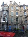 | |||
| Sciennes House Place, Fire Station And Gatepiers | 55°56′16″N 3°10′54″W | Category C(S) | 30475 | | |||
| Sciennes Road, Royal Hospital For Sick Children Including Mortuary And Mortuary Chapel | 55°56′18″N 3°11′20″W | Category B | 30480 | | |||
| 9 And 11 Seton Place Including Boundary Walls | 55°56′07″N 3°11′01″W | Category B | 30481 |  | |||
| 13 Sylvan Place, Sylvan House, Including Boundary Walls | 55°56′19″N 3°11′27″W | Category B | 30485 | | |||
| 35 37 And 39 Blackford Road With Boundary Wall Gates And Gatepiers | 55°55′56″N 3°11′38″W | Category B | 30497 | | |||
| 1-12 Bruntsfield Crescent Boundary Walls And Railings | 55°56′10″N 3°12′11″W | Category A | 30498 | | |||
| 6-11 (Inclusive Nos) Glenisla Gardens | 55°55′38″N 3°11′21″W | Category B | 30503 | | |||
| Grange Loan, Pillar Surmounted By Wyvern Set Into Mutual Wall Between 108-110 (Even Nos) Grange Loan And 2 Lauder Road | 55°55′55″N 3°11′04″W | Category B | 30381 | | |||
| 186-204 (Even Nos) Grange Loan | 55°55′52″N 3°11′26″W | Category C(S) | 30385 | | |||
| 1-7 (Inclusive Nos) Grange Road And 128-138 Causewayside | 55°56′12″N 3°10′50″W | Category C(S) | 30387 | | |||
| 11A, 11B, And 13 Grange Road | 55°56′13″N 3°10′56″W | Category C(S) | 30388 | | |||
| 60 Grange Road, Superintendent's Lodge To Grange Cemetery | 55°56′07″N 3°11′25″W | Category B | 30395 | 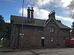 | |||
| Grange Road And Beaufort Road, Edinburgh Southern Cemetery (Grange), Including Boundary Walls, Railings, Gates And Gatepiers | 55°56′02″N 3°11′35″W | Category B | 30396 | 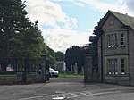 | |||
| 1-18 (Inclusive Nos) Grange Terrace | 55°55′49″N 3°11′17″W | Category C(S) | 30397 | | |||
| 38 Lauder Road | 55°56′11″N 3°11′18″W | Category C(S) | 30415 | | |||
| 1-6 (Inclusive Nos) Lord Russell Place And 12 Sciennes | 55°56′21″N 3°10′56″W | Category B | 30422 | 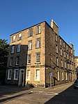 | |||
| 37 And 37A Mansionhouse Road, Boundary Walls And Railings | 55°56′04″N 3°11′18″W | Category B | 30426 | | |||
| 30, 30A, 32 And 32A Mansionhouse Road | 55°56′04″N 3°11′16″W | Category B | 30432 | | |||
| 50-54 (Even Nos) Marchmont Crescent | 55°56′14″N 3°11′35″W | Category B | 30435 | 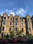 | |||
| 92-104 (Even Nos) Marchmont Crescent | 55°56′10″N 3°11′38″W | Category B | 30442 | 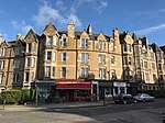 | |||
| 83-87 Marchmont Road | 55°56′09″N 3°11′38″W | Category B | 30444 | 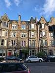 | |||
| 95-99 (Odd Nos) Marchmont Road | 55°56′08″N 3°11′38″W | Category B | 30445 | 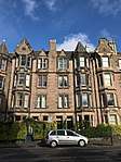 | |||
| 5 And 7 (Formerly 14 And 16) Richmond Place, Former Royal Blind Asylum School Workshops | 55°56′46″N 3°11′00″W | Category B | 30304 | | |||
| 18 Liberton Brae, Liberton Tower Mains, Farmhouse And Steading | 55°55′03″N 3°10′08″W | Category B | 30305 | | |||
| 3-8 (Inclusive Nos) Trinity Way, Mayfield House And 109 East Trinity Road (Former Lodge), Boundary Walls, Gates And Gatepiers | 55°58′30″N 3°12′23″W | Category C(S) | 30318 | | |||
| 27-29 Buccleuch Street Including Boundary Wall | 55°56′36″N 3°11′04″W | Category B | 30320 | | |||
| 39 And 41 Frogston Road West, Princess Margaret Rose Hospital, West Gate Lodge With Gatepiers, Gates And Boundary Walls | 55°53′58″N 3°11′49″W | Category C(S) | 30327 | | |||
| 41 And 43 Frogston Road West, Princess Margaret Rose Hospital, Nurses' Home | 55°54′03″N 3°11′50″W | Category B | 30329 | | |||
| Causewayside And Grange Road, Salisbury Church (Formerly Newington South And Hope Park Church) Including Church Hall And Offices | 55°56′13″N 3°10′53″W | Category B | 30343 | 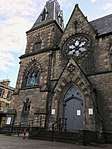 | |||
| 59 Dick Place Including Boundary Walls | 55°55′59″N 3°11′32″W | Category C(S) | 30356 | | |||
| 48 And 50 Dick Place Including Gatepiers And Boundary Walls | 55°55′58″N 3°11′26″W | Category A | 30368 | | |||
| 1-7 (Inclusive Nos) Fingal Place, 1 Sylvan Place, And 1 Argyle Place | 55°56′22″N 3°11′28″W | Category B | 30371 | 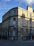 | |||
| 53 Fountainhall Road Including Boundary Wall And Gatepiers | 55°55′52″N 3°10′59″W | Category B | 30372 | | |||
| 6 Castlelaw Road | 55°54′12″N 3°15′33″W | Category B | 30226 | | |||
| Grassmarket, 2 K6 Telephone Kiosks | 55°56′51″N 3°11′44″W | Category B | 30231 | | |||
| Great King Street, K6 Telephone Kiosk | 55°57′28″N 3°11′59″W | Category B | 30249 | | |||
| 11-23 (Odd Nos) Morningside Drive | 55°55′27″N 3°12′39″W | Category C(S) | 30258 | | |||
| Cammo Road, Cammo Estate, Stable Block (Off Cammo Walk) | 55°57′20″N 3°19′23″W | Category B | 30259 | | |||
| Cammo Road, Cammo Estate, Gatepiers, Railings And Boundary Wall | 55°57′34″N 3°19′08″W | Category B | 30260 | | |||
| 21-27 Edina Place (Odd Numbers) And 26 Norton Park (Former Edina Works) | 55°57′35″N 3°10′11″W | Category B | 30271 | | |||
| 100-104 (Even Nos) George Street And 35 Castle Street, Pearl Assurance Building | 55°57′09″N 3°12′11″W | Category B | 30272 | 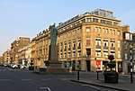 | |||
| 1, 3 And 5 Howdenhall Road | 55°54′17″N 3°09′55″W | Category B | 30278 | | |||
| New Market Road, Livestock Sheds | 55°55′32″N 3°15′00″W | Category B | 30283 | | |||
| 1 And 1A Easter Belmont Road | 55°56′55″N 3°15′06″W | Category B | 30291 | | |||
| 1-42 (Inclusive Nos) Patriothall | 55°57′31″N 3°12′23″W | Category B | 30299 | | |||
| 28 And 30 Nicolson Street And 21 Hill Place, The Royal Bank Of Scotland Building | 55°56′46″N 3°11′06″W | Category B | 30141 | 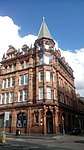 | |||
| 20-52 (Even Nos) North Bridge Including Scotsman Hotel, Scotsman Steps, Arcade, Royal Mile Mansions, 175 And 177 High Street And 65-71 (Odd Nos) Cockburn Street | 55°57′03″N 3°11′18″W | Category A | 30143 | 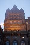 | |||
| St Stephen Street 79-87 | 55°57′31″N 3°12′21″W | Category B | 30172 | | |||
| 102 Trinity Road, Kirtle Lodge, Including Garden House, Boundary Walls And Gatepiers | 55°58′40″N 3°12′23″W | Category B | 30187 | | |||
| 50 West Port, Former Police And Fire Stations, Including Boundary Wall And Railings | 55°56′47″N 3°11′58″W | Category C(S) | 30193 | | |||
| 62-76 (Even Nos) West Port, Including 1-32 (Inclusive Nos) Cordiners' Land And Garden Walls And Railings | 55°56′47″N 3°12′00″W | Category C(S) | 30195 | | |||
| 15 Calton Hill | 55°57′15″N 3°11′10″W | Category B | 30204 | | |||
| 1D And 1E Duddingston Park And 61, 63, 64 - 72 (Inclusive Nos) Park Avenue, Portobello High School Annexe With Retaining Walls, Gates And Gatepiers | 55°56′54″N 3°07′07″W | Category B | 30207 | | |||
| 160 Lower Granton Road, The Granton Tap | 55°58′51″N 3°13′23″W | Category B | 30215 | | |||
| Carrington Road, Fettes College, Kimmerghame House | 55°57′41″N 3°13′43″W | Category B | 30223 | | |||
| 33 Braehead Drive, Braehead House And Nos 1 And 3 Brae Park Road (Former Service Wing), Including Sundial, Boundary Wall, Gatepiers | 55°57′55″N 3°18′37″W | Category B | 30054 | | |||
| 6 Bell's Brae | 55°57′09″N 3°12′55″W | Category C(S) | 30067 | | |||
| 56-60 (Even Nos) Broughton Street, Including Railings | 55°57′31″N 3°11′26″W | Category B | 30073 | | |||
| 62-66 (Even Nos) Broughton Street, Including Railings | 55°57′31″N 3°11′26″W | Category B | 30074 | | |||
| 55 And 57 Cockburn Street | 55°57′03″N 3°11′21″W | Category B | 30083 | | |||
| 18 And 20 Cockburn Street | 55°57′02″N 3°11′24″W | Category B | 30087 | |
Key
The scheme for classifying buildings in Scotland is:
- Category A: "buildings of national or international importance, either architectural or historic; or fine, little-altered examples of some particular period, style or building type."[1]
- Category B: "buildings of regional or more than local importance; or major examples of some particular period, style or building type, which may have been altered."[1]
- Category C: "buildings of local importance; lesser examples of any period, style, or building type, as originally constructed or moderately altered; and simple traditional buildings which group well with other listed buildings."[1]
In March 2016 there were 47,288 listed buildings in Scotland. Of these, 8 per cent were Category A, and 50 per cent were Category B, with the rest listed at Category C.[2]
Notes
- Sometimes known as OSGB36, the grid reference (where provided) is based on the British national grid reference system used by the Ordnance Survey.
• "Guide to National Grid". Ordnance Survey. Retrieved 12 December 2007.
• "Get-a-map". Ordnance Survey. Retrieved 17 December 2007. - Historic Environment Scotland assign a unique alphanumeric identifier to each designated site in Scotland, for listed buildings this always begins with "LB", for example "LB12345".
References
- All entries, addresses and coordinates are based on data from Historic Scotland. This data falls under the Open Government Licence
- "What is Listing?". Historic Environment Scotland. Retrieved 29 May 2018.
- Scotland's Historic Environment Audit 2016 (PDF). Historic Environment Scotland and the Built Environment Forum Scotland. pp. 15–16. Retrieved 29 May 2018.
This article is issued from Wikipedia. The text is licensed under Creative Commons - Attribution - Sharealike. Additional terms may apply for the media files.