List of listed buildings in Dyke And Moy, Moray
List
| Name | Location | Date Listed | Grid Ref. [note 1] | Geo-coordinates | Notes | LB Number [note 2] | Image |
|---|---|---|---|---|---|---|---|
| Brodie Castle, Station Lodge And Gatepiers | 57°35′38″N 3°42′39″W | Category C(S) | 2262 |  | |||
| Brodie Castle, West Lodge | 57°35′48″N 3°42′59″W | Category C(S) | 2263 | | |||
| Darnaway, Whitemire Village, No 63 (Pinewood) No 64 | 57°33′57″N 3°42′36″W | Category B | 2267 | | |||
| Earlsmill Bridge Over Muckle Burn | 57°34′59″N 3°43′31″W | Category C(S) | 2270 | | |||
| Findhorn Bridge Over River Findhorn | 57°36′08″N 3°39′19″W | Category B | 2273 | | |||
| Darnaway Castle, Stables And Carriage-House | 57°34′25″N 3°40′57″W | Category B | 2284 | | |||
| Darnaway, West Lodge, Gatepiers And Gates | 57°34′46″N 3°42′54″W | Category A | 2288 | | |||
| Barleymill Bridge Over Muckle Burn | 57°35′46″N 3°41′47″W | Category B | 2258 | | |||
| Earlsmill House And Gatepiers | 57°34′51″N 3°43′16″W | Category B | 2271 | | |||
| Moy Mains, Former Stables And Carriage-Houses | 57°37′15″N 3°38′53″W | Category A | 2276 | | |||
| Dalvey House, East Lodge And Gatepiers | 57°36′21″N 3°39′54″W | Category C(S) | 2281 | | |||
| Dalvey Cottage | 57°36′03″N 3°40′07″W | Category B | 2282 | | |||
| Moy Bridge Over Muckle Burn | 57°37′22″N 3°39′04″W | Category B | 2292 | | |||
| Bernera Cottage | 57°36′38″N 3°40′59″W | Category B | 2259 | | |||
| Darnaway, Whitemire Village, No 65 (The Neuk) | 57°33′57″N 3°42′37″W | Category B | 2268 | | |||
| Dyke Parish Church (Church Of Scotland), Church Hall, (Former Mausoleum), Burial Ground And War Memorial Gate Arch | 57°36′16″N 3°41′29″W | Category A | 2269 | 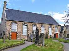 | |||
| Kincorth House And Garden Walls | 57°38′00″N 3°39′21″W | Category B | 2274 | | |||
| Moy House And Gatepiers | 57°37′08″N 3°39′01″W | Category A | 2275 | | |||
| Dalvey House, Gardener's Cottage | 57°36′23″N 3°39′59″W | Category C(S) | 2280 | | |||
| Darnaway, Keeper's House And Kennels | 57°34′58″N 3°40′48″W | Category B | 2286 | | |||
| Darnaway, East Lodge, Gatepiers And Gates | 57°35′28″N 3°41′03″W | Category A | 2287 | | |||
| Abbotshill Bridge Over Muckle Burn | 57°36′16″N 3°40′43″W | Category B | 2257 | | |||
| Brodie Castle, Burial Ground | 57°35′42″N 3°43′09″W | Category B | 2264 | | |||
| Darnaway, Whitemire Village, No 59 (Kistie) No 60 (Randolph) | 57°33′58″N 3°42′34″W | Category B | 2265 | | |||
| Darnaway, Whitemire Village, No 61 (Stephen) No 62 | 57°33′57″N 3°42′35″W | Category C(S) | 2266 | | |||
| Dalvey House | 57°36′25″N 3°40′07″W | Category B | 2277 | | |||
| Dalvey House, Dovecot | 57°36′27″N 3°40′10″W | Category B | 2278 | | |||
| Darnaway Castle And Terraces | 57°34′28″N 3°41′02″W | Category A | 2283 | | |||
| Tearie Farmhouse | 57°35′27″N 3°41′40″W | Category C(S) | 2293 | | |||
| Darnaway, Walled Garden, East. Gatepiers And Gates (Redstone Nursery Gardens) | 57°34′12″N 3°40′44″W | Category B | 2285 | | |||
| Dalvey House, Bridge Over The Muckle Burn | 57°36′22″N 3°40′01″W | Category B | 2279 | | |||
| Brodie Castle | 57°35′54″N 3°42′32″W | Category A | 2260 | .JPG) | |||
| Brodie Castle, Stables | 57°35′29″N 3°42′41″W | Category B | 2261 | | |||
| Feddan Farmhouse | 57°35′12″N 3°43′38″W | Category B | 2272 | |
Key
The scheme for classifying buildings in Scotland is:
- Category A: "buildings of national or international importance, either architectural or historic; or fine, little-altered examples of some particular period, style or building type."[1]
- Category B: "buildings of regional or more than local importance; or major examples of some particular period, style or building type, which may have been altered."[1]
- Category C: "buildings of local importance; lesser examples of any period, style, or building type, as originally constructed or moderately altered; and simple traditional buildings which group well with other listed buildings."[1]
In March 2016 there were 47,288 listed buildings in Scotland. Of these, 8 per cent were Category A, and 50 per cent were Category B, with the rest listed at Category C.[2]
See also
Notes
- Sometimes known as OSGB36, the grid reference (where provided) is based on the British national grid reference system used by the Ordnance Survey.
• "Guide to National Grid". Ordnance Survey. Retrieved 2007-12-12.
• "Get-a-map". Ordnance Survey. Retrieved 2007-12-17. - Historic Environment Scotland assign a unique alphanumeric identifier to each designated site in Scotland, for listed buildings this always begins with "LB", for example "LB12345".
References
- All entries, addresses and coordinates are based on data from Historic Scotland. This data falls under the Open Government Licence
- "What is Listing?". Historic Environment Scotland. Retrieved 29 May 2018.
- Scotland's Historic Environment Audit 2016 (PDF). Historic Environment Scotland and the Built Environment Forum Scotland. pp. 15–16. Retrieved 29 May 2018.
This article is issued from Wikipedia. The text is licensed under Creative Commons - Attribution - Sharealike. Additional terms may apply for the media files.