List of listed buildings in Cross And Burness, Orkney
List
| Name | Location | Date Listed | Grid Ref. [note 1] | Geo-coordinates | Notes | LB Number [note 2] | Image |
|---|---|---|---|---|---|---|---|
| North Ronaldsay, Holland House Steading, Factor's House And Bothy | 59°21′50″N 2°25′52″W | Category C(S) | 44588 |  | |||
| North Ronaldsay, Verracott | 59°22′31″N 2°25′40″W | Category B | 43853 | | |||
| North Ronaldsay, Dennis Head Beacon, Including Remains Of Keepers' Houses | 59°23′03″N 2°22′17″W | Category A | 5891 | 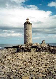 | |||
| North Ronaldsay, Versa Breck, North Ronaldsay Lighthouse, Including Keepers' Houses, Boundary Walls And Foghorn | 59°23′22″N 2°22′53″W | Category B | 5892 | | |||
| North Ronaldsay, Holland House, Including Outbuildings, Garden Walls, Steading And Cottages | 59°21′49″N 2°25′51″W | Category C(S) | 5274 | | |||
| North Ronaldsay, Gateside, Including Outbuildings | 59°21′33″N 2°25′03″W | Category B | 46393 | | |||
| Sanday, Kettletoft, Kettletoft Pier, Including Slipway | 59°13′52″N 2°35′55″W | Category B | 46402 | | |||
| Sanday, Cross, Warsetter Farm, Including Boundary Walls, Gatepiers And Ancillary Farm Courtyard With Threshing Barn | 59°13′30″N 2°39′07″W | Category B | 5905 | | |||
| Sanday, Westove, Scar House, Including Ancillary Range With Mill And Doocot, Walled Garden And Farm Cottages | 59°17′30″N 2°34′50″W | Category B | 5908 | | |||
| Sanday, Marygarth Manse With Ancillary Buildings Including Drying Kiln, Boundary Walls And Gatepiers | 59°15′21″N 2°36′30″W | Category B | 54 | | |||
| Sanday, Stove Farmhouse And Farm Cottages | 59°12′17″N 2°41′11″W | Category B | 46404 | | |||
| North Ronaldsay, New Church, (Former Uf Church) | 59°22′14″N 2°25′40″W | Category B | 45267 | | |||
| North Ronaldsay, Peckhole Windmill | 59°21′41″N 2°25′07″W | Category B | 44589 | | |||
| Sanday, Burness, Saville Farmhouse Including Ancillary Buildings | 59°17′01″N 2°33′34″W | Category B | 5909 | | |||
| North Ronaldsay, Dennis Head, Fishing Station And Pier | 59°23′04″N 2°22′39″W | Category C(S) | 46392 | | |||
| Sanday, Backaskaill Mains | 59°14′21″N 2°37′46″W | Category B | 46401 | | |||
| Sanday, Cross, Warsetter Farm Cottages | 59°13′39″N 2°38′49″W | Category B | 46405 | | |||
| North Ronaldsay, Old Kirk, (Formerly Free Church), Including Boundary Walls And Gatepiers | 59°21′53″N 2°26′01″W | Category B | 5273 | | |||
| North Ronaldsay, Nouster | 59°21′27″N 2°26′27″W | Category C(S) | 46397 | | |||
| Sanday, Cross, Warsetter Farm, Doocot | 59°13′28″N 2°38′58″W | Category B | 5906 | | |||
| North Ronaldsay, Lurand, Including Boundary Walls And Outbuildings | 59°21′30″N 2°26′45″W | Category C(S) | 46394 | | |||
| Sanday, Boloquoy Farm, Including Boundary Walls, Ancillary Buildings, Meal Mill And Farm Cottages | 59°14′11″N 2°39′26″W | Category B | 5907 | | |||
| Sanday, Quivals Farmhouse, (Former School), Including Boundary Wall And Ancillary Buildings | 59°15′49″N 2°34′48″W | Category B | 5910 | | |||
| North Ronaldsay, Peckhole Mill | 59°21′41″N 2°25′08″W | Category B | 46398 | | |||
| North Ronaldsay, Sheep Dyke And Associated Punds | 59°22′19″N 2°24′55″W | Category A | 46400 | | |||
| Sanday, Westove, Scar Former Windmill | 59°17′23″N 2°34′28″W | Category B | 6189 | | |||
| North Ronaldsay, Nether Linnay | 59°22′59″N 2°25′34″W | Category B | 46395 | | |||
| North Ronaldsay, Linklet House, Including Outbuilding, Boundary Walls And Gatepiers | 59°22′12″N 2°25′41″W | Category C(S) | 46396 | | |||
| Sanday, Westove, Scar Former Water Mill | 59°17′34″N 2°35′04″W | Category B | 46403 | | |||
| North Ronaldsay, Rue, Including Outbuildings And Boundary Walls | 59°23′11″N 2°22′55″W | Category B | 6688 | | |||
| North Ronaldsay, Hooking Watermill | 59°21′58″N 2°24′45″W | Category C(S) | 6192 | | |||
| North Ronaldsay, Barren Ha | 59°22′05″N 2°25′05″W | Category C(S) | 46391 | | |||
| North Ronaldsay, Sandback | 59°22′59″N 2°23′49″W | Category C(S) | 46399 | | |||
| North Ronaldsay, War Memorial | 59°22′09″N 2°25′39″W | Category C(S) | 49985 | |
Key
The scheme for classifying buildings in Scotland is:
- Category A: "buildings of national or international importance, either architectural or historic; or fine, little-altered examples of some particular period, style or building type."[1]
- Category B: "buildings of regional or more than local importance; or major examples of some particular period, style or building type, which may have been altered."[1]
- Category C: "buildings of local importance; lesser examples of any period, style, or building type, as originally constructed or moderately altered; and simple traditional buildings which group well with other listed buildings."[1]
In March 2016 there were 47,288 listed buildings in Scotland. Of these, 8 per cent were Category A, and 50 per cent were Category B, with the rest listed at Category C.[2]
See also
Notes
- Sometimes known as OSGB36, the grid reference (where provided) is based on the British national grid reference system used by the Ordnance Survey.
• "Guide to National Grid". Ordnance Survey. Retrieved 2007-12-12.
• "Get-a-map". Ordnance Survey. Retrieved 2007-12-17. - Historic Environment Scotland assign a unique alphanumeric identifier to each designated site in Scotland, for listed buildings this always begins with "LB", for example "LB12345".
References
- All entries, addresses and coordinates are based on data from Historic Scotland. This data falls under the Open Government Licence
- "What is Listing?". Historic Environment Scotland. Retrieved 29 May 2018.
- Scotland's Historic Environment Audit 2016 (PDF). Historic Environment Scotland and the Built Environment Forum Scotland. pp. 15–16. Retrieved 29 May 2018.
This article is issued from Wikipedia. The text is licensed under Creative Commons - Attribution - Sharealike. Additional terms may apply for the media files.