List of listed buildings in Beith, North Ayrshire
List
| Name | Location | Date Listed | Grid Ref. [note 1] | Geo-coordinates | Notes | LB Number [note 2] | Image |
|---|---|---|---|---|---|---|---|
| 25-31 (Odd Nos) Eglinton Street, former Post Office | 55°45′00″N 4°38′02″W | Category C(S) | 911 | .jpg) | |||
| 10 and 12 Eglinton Street, Saracen's Head | 55°45′02″N 4°38′00″W | Category B | 921 | .jpg) | |||
| 14 and 16 Eglinton Street | 55°45′01″N 4°38′01″W | Category C(S) | 922 |  | |||
| 2-6 (Even Nos) Reform Street | 55°45′05″N 4°37′57″W | Category B | 934 | | |||
| 2 and 2A Barrmill Road, Knockbuckle and Knockbuckle Cottage, including Boundary Walls and Gatepiers | 55°44′56″N 4°37′53″W | Category B | 938 | | |||
| Wilson Street, Beith Trinity Church (Church Of Scotland), including Hall, Boundary Walls, Railings and Gatepiers | 55°45′16″N 4°37′43″W | Category C(S) | 942 |  | |||
| Woodside Farm, formerly Stables to Woodside House | 55°45′54″N 4°38′03″W | Category B | 945 | | |||
| Wester Highgate Farm and Highgate House, including Original Outbuildings and Walled Garden | 55°44′06″N 4°33′54″W | Category B | 962 | | |||
| Barrmill, Dunlop Road, Giffen Mill and Millhouse | 55°43′41″N 4°35′51″W | Category B | 876 | | |||
| 29 Braehead | 55°45′01″N 4°37′57″W | Category C(S) | 880 | | |||
| Bigholm Road, Hamilfield, including Walled Garden and Boundary Walls | 55°45′19″N 4°37′39″W | Category B | 881 | | |||
| Cuff Farm, including Boundary Walls, Gatepiers and Gates | 55°45′22″N 4°35′17″W | Category C(S) | 49728 | | |||
| Janefield Place, War Memorial | 55°45′16″N 4°38′07″W | Category C(S) | 49738 |  | |||
| Gateside, Bog Hall, including former Farm Buildings to Rear | 55°45′07″N 4°36′42″W | Category C(S) | 49732 |  | |||
| 66 Eglinton Street | 55°44′59″N 4°38′11″W | Category C(S) | 894 | | |||
| Hazelhead | 55°44′34″N 4°34′36″W | Category C(S) | 905 | | |||
| 53 and 55 Main Street, The Smugglers Tavern | 55°45′07″N 4°37′53″W | Category B | 931 | | |||
| Mitchell Street Roman Catholic Church (Former United Free), Including Gates, Gatepiers And Boundary Walls | 55°45′08″N 4°37′50″W | Category C(S) | 933 |  | |||
| 5-9 (Odd Nos) The Strand | 55°45′00″N 4°37′59″W | Category C(S) | 935 | | |||
| 35 Wilson Street | 55°45′10″N 4°37′50″W | Category C(S) | 940 | | |||
| Easter Highgate including Boundary Walls, Railings and Gatepiers | 55°44′02″N 4°33′48″W | Category B | 958 | | |||
| 31 Braehead, Clydesdale Bank, including Boundary Walls | 55°45′00″N 4°37′56″W | Category B | 879 | .jpg) | |||
| 35A Wilson Street, Newton House | 55°45′11″N 4°37′49″W | Category C(S) | 117 | | |||
| 64 Eglinton Street, including Outbuilding | 55°44′59″N 4°38′11″W | Category B | 893 | | |||
| Geilsland Road, Geilsland Church of Scotland School | 55°44′50″N 4°37′24″W | Category B | 901 | | |||
| Hessilhead | 55°44′34″N 4°34′27″W | Category C(S) | 906 | | |||
| 1 Glebe Road, The Old Manse, including Boundary Walls, Gatepiers and Railings | 55°44′54″N 4°38′09″W | Category B | 918 | | |||
| 1620 (Even Nos) Main Street | 55°45′05″N 4°37′55″W | Category C(S) | 924 | | |||
| 22 and 24 Main Street | 55°45′05″N 4°37′55″W | Category C(S) | 925 | | |||
| 57-61 (Odd Nos) Main Street | 55°45′07″N 4°37′53″W | Category C(S) | 932 | | |||
| 12 The Strand, Including Boundary Walls | 55°44′59″N 4°37′59″W | Category B | 936 | | |||
| 2 The Strand, former Townhouse | 55°45′00″N 4°38′01″W | Category B | 937 | .jpg) | |||
| Balgray Barn | 55°44′16″N 4°35′31″W | Category B | 875 | 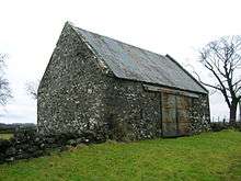 | |||
| 24-28 (Even Nos) The Cross | 55°45′02″N 4°37′59″W | Category B | 884 | | |||
| 44 Eglinton Street | 55°45′00″N 4°38′05″W | Category B | 888 | | |||
| Arran Crescent, The Meadows, including Meadows Cottage (Former Service Wing) | 55°45′20″N 4°37′47″W | Category B | 49725 | | |||
| Gateside, Main Street, Patrick Memorial Hall | 55°44′53″N 4°36′28″W | Category C(S) | 49735 | | |||
| 32 and 34 Main Street, Blackwood The Butchers' | 55°45′05″N 4°37′54″W | Category C(S) | 49740 | | |||
| 63 Wilson Street, Dunlop Cottage, including Boundary Walls | 55°45′14″N 4°37′47″W | Category C(S) | 49742 | | |||
| 65 Wilson Street, Barrington House, including Former Coachhouse, Boundary Walls, Gatepiers and Gates | 55°45′15″N 4°37′47″W | Category B | 49743 | | |||
| 74 Eglinton Street | 55°44′58″N 4°38′13″W | Category B | 897 | | |||
| Threepwood Road, The Courtyard, (Former Grangehill Stables And Kennels) | 55°45′22″N 4°37′15″W | Category B | 903 | | |||
| 13-17 (Odd Nos) Eglinton Street, Anderson Hotel | 55°45′00″N 4°38′02″W | Category B | 910 | .jpg) | |||
| 33 And 35 Eglinton Street | 55°44′59″N 4°38′03″W | Category B | 912 | | |||
| 43 Eglinton Street | 55°45′00″N 4°38′05″W | Category C(S) | 915 | | |||
| 45 Eglinton Street | 55°44′59″N 4°38′05″W | Category C(S) | 916 | | |||
| 26-30 (Even Nos) Main Street | 55°45′05″N 4°37′54″W | Category B | 926 | | |||
| Middleton | 55°44′16″N 4°33′25″W | Category C(S) | 960 | | |||
| The Cross, Old Parish Church and Burial Ground, including Vault and Boundary Walls | 55°45′03″N 4°37′59″W | Category C(S) | 882 |  | |||
| 18-22 (Even Nos) Eglinton Street, Irvine's The Baker | 55°45′01″N 4°38′01″W | Category C(S) | 885 | | |||
| 76 Eglinton Street,Including Boundary Walls And Ancillary Buildings | 55°44′57″N 4°38′15″W | Category B | 116 | | |||
| Balgray Cottage | 55°44′16″N 4°35′34″W | Category C(S) | 49726 | | |||
| Barrmill Road, Gatepiers, Railings And Boundary Walls To Former Spier's School | 55°44′40″N 4°37′36″W | Category C(S) | 49727 | | |||
| Gateside, 49 Main Street, Drissaig | 55°44′53″N 4°36′27″W | Category C(S) | 49734 | | |||
| Gateside, 23 Main Street | 55°44′52″N 4°36′34″W | Category C(S) | 49733 | | |||
| 19-23 (Odd Nos) Eglinton Street | 55°45′00″N 4°38′02″W | Category B | 4851 | | |||
| 72 Eglinton Street | 55°44′58″N 4°38′13″W | Category B | 896 | | |||
| 9 Eglinton Street and 1, 3 The Strand | 55°45′01″N 4°37′59″W | Category C(S) | 909 | | |||
| 37 Eglinton Street, including Stairs, Boundary Walls, Railings and Gatepiers to Rear | 55°45′00″N 4°38′04″W | Category B | 913 | | |||
| 2 and 4 Eglinton Street | 55°45′02″N 4°37′59″W | Category C(S) | 919 | | |||
| 6 and 8 Eglinton Street | 55°45′02″N 4°38′00″W | Category C(S) | 920 | | |||
| 4 Barrmill Road, Taynish, including Boundary Walls Railings and Gatepiers | 55°44′55″N 4°37′52″W | Category B | 939 | | |||
| 20 and 22 The Cross | 55°45′02″N 4°38′00″W | Category B | 883 | | |||
| 40 and 42 Eglinton Street | 55°45′01″N 4°38′04″W | Category C(S) | 887 | | |||
| 70 Eglinton Street | 55°44′58″N 4°38′13″W | Category C(S) | 895 | | |||
| Drumbuie Farm | 55°43′11″N 4°37′10″W | Category B | 899 | | |||
| Drumbuie House and Detached Barn, including adjacent Byre | 55°43′12″N 4°37′07″W | Category B | 900 | | |||
| 39 and 41 Eglinton Street | 55°45′00″N 4°38′04″W | Category C(S) | 914 | | |||
| 35-45 (Odd Nos) Main Street, Beith Library | 55°45′06″N 4°37′55″W | Category B | 930 | | |||
| Woodside House, including Boundary Walls and Gatepiers | 55°45′49″N 4°38′07″W | Category A | 943 | 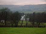 | |||
| Woodside South Lodge | 55°45′34″N 4°38′20″W | Category C(S) | 944 | | |||
| 32 Eglinton Street, Bank Of Scotland | 55°45′01″N 4°38′03″W | Category B | 886 | .jpg) | |||
| 41 Laigh Road and 43 Woodside Road, Victoria Villa, including Boundary Walls and Gatepiers | 55°45′15″N 4°38′00″W | Category B | 49739 |  | |||
| 60 Eglinton Street | 55°44′59″N 4°38′09″W | Category C(S) | 891 | | |||
| 62 Eglinton Street, Whang House, including Ruined Chapel to Rear, Boundary Walls and Gatepiers | 55°44′59″N 4°38′10″W | Category B | 892 |  | |||
| Head Street, former United Free Church, including Boundary Walls, Railings, Gates and Gatepiers | 55°45′03″N 4°37′39″W | Category B | 898 |  | |||
| Threepwood Road, Grangehill Walled Garden and Doocot | 55°45′24″N 4°37′11″W | Category C(S) | 902 | | |||
| 30 The Cross | 55°45′02″N 4°37′59″W | Category B | 908 | | |||
| 87 Eglinton Street, including Boundary Walls and Outbuilding to Rear | 55°44′54″N 4°38′14″W | Category B | 917 | | |||
| Kirk Road, High Church, including Boundary Walls, Gatepiers and Gates | 55°44′58″N 4°37′53″W | Category B | 923 |  | |||
| 58-62 (Even Nos) Main Street | 55°45′07″N 4°37′52″W | Category C(S) | 927 | | |||
| 15-19 (Odd Nos) Main Street, including Return to Reform Street and Former Bakery Buildings to Rear | 55°45′05″N 4°37′56″W | Category C(S) | 929 | | |||
| Gatend Byre, Gatend Farm | 55°43′16″N 4°37′00″W | Category B | 49731 | | |||
| High Orchard | 55°44′13″N 4°33′00″W | Category C(S) | 959 | | |||
| Willowyard | 55°44′48″N 4°39′16″W | Category B | 963 |  | |||
| 46 Eglinton Street | 55°45′00″N 4°38′06″W | Category B | 889 | | |||
| 10 Dalry Road | 55°44′54″N 4°38′20″W | Category C(S) | 49730 | | |||
| 12 Glebe Road, Craigallan | 55°44′50″N 4°38′12″W | Category B | 49736 | | |||
| 31 Head Street, including Former Byre to Rear | 55°45′05″N 4°37′44″W | Category C(S) | 49737 | | |||
| 17 and 19 Wilson Street | 55°45′09″N 4°37′51″W | Category C(S) | 49741 | |
Key
The scheme for classifying buildings in Scotland is:
- Category A: "buildings of national or international importance, either architectural or historic; or fine, little-altered examples of some particular period, style or building type."[1]
- Category B: "buildings of regional or more than local importance; or major examples of some particular period, style or building type, which may have been altered."[1]
- Category C: "buildings of local importance; lesser examples of any period, style, or building type, as originally constructed or moderately altered; and simple traditional buildings which group well with other listed buildings."[1]
In March 2016 there were 47,288 listed buildings in Scotland. Of these, 8 per cent were Category A, and 50 per cent were Category B, with the rest listed at Category C.[2]
Notes
- Sometimes known as OSGB36, the grid reference (where provided) is based on the British national grid reference system used by the Ordnance Survey.
• "Guide to National Grid". Ordnance Survey. Retrieved 2007-12-12.
• "Get-a-map". Ordnance Survey. Retrieved 2007-12-17. - Historic Environment Scotland assign a unique alphanumeric identifier to each designated site in Scotland, for listed buildings this always begins with "LB", for example "LB12345".
References
- All entries, addresses and coordinates are based on data from Historic Scotland. This data falls under the Open Government Licence
- "What is Listing?". Historic Environment Scotland. Retrieved 29 May 2018.
- Scotland's Historic Environment Audit 2016 (PDF). Historic Environment Scotland and the Built Environment Forum Scotland. pp. 15–16. Retrieved 29 May 2018.
This article is issued from Wikipedia. The text is licensed under Creative Commons - Attribution - Sharealike. Additional terms may apply for the media files.