List of listed buildings in Ardrossan, North Ayrshire
List
| Name | Location | Date Listed | Grid Ref. [note 1] | Geo-coordinates | Notes | LB Number [note 2] | Image |
|---|---|---|---|---|---|---|---|
| 56, Eglinton Road | 55°38′59″N 4°48′44″W | Category B | 21331 |  | |||
| Dalry Road, Mill Farm | 55°39′42″N 4°48′22″W | Category C(S) | 21334 | | |||
| St Peter-in-Chains RC Church Pavilion Place and South Crescent | 55°38′27″N 4°48′33″W | Category A | 21335 |  | |||
| 26, South Crescent Road, former St Andrew's Rectory | 55°38′23″N 4°47′55″W | Category B | 21261 | .jpg) | |||
| 6 Arran Place | 55°38′23″N 4°48′38″W | Category B | 21271 | | |||
| 4 South Crescent Road | 55°38′27″N 4°48′27″W | Category B | 21278 | | |||
| Harbour Street Nichols Bar | 55°38′22″N 4°48′55″W | Category B | 21309 | | |||
| 86, 88 Glasgow Street | 55°38′31″N 4°48′46″W | Category B | 21321 | | |||
| 94, 96 Glasgow Street | 55°38′32″N 4°48′46″W | Category B | 21323 | | |||
| Eglinton Road Seafield (Now School) | 55°39′08″N 4°49′00″W | Category B | 21328 | | |||
| Seafield Eglinton Road. Stables | 55°39′09″N 4°49′04″W | Category B | 21329 | | |||
| St Andrew's Episcopal Church, South Crescent Road | 55°38′23″N 4°47′53″W | Category B | 21260 | | |||
| Ardrossan Castle | 55°38′31″N 4°48′36″W | Now scheduled monument SM3383 | 21266 |  | |||
| 2 South Crescent Road | 55°38′26″N 4°48′31″W | Category C(S) | 21276 | | |||
| 3 South Crescent Road | 55°38′27″N 4°48′29″W | Category C(S) | 21277 | | |||
| 5 South Crescent Road | 55°38′27″N 4°48′25″W | Category B | 21279 | | |||
| Bath Villa (No 90 Princes Street) | 55°38′20″N 4°48′41″W | Category B | 21288 | | |||
| 30, 32 Glasgow Street | 55°38′27″N 4°48′51″W | Category B | 21312 | | |||
| Montfode Castle | 55°39′30″N 4°49′17″W | Now scheduled monument SM5816 | 105 | 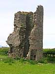 | |||
| Winton Primary School Anderson Terrace | 55°38′40″N 4°48′25″W | Category C(S) | 21333 | | |||
| Town Hall Glasgow Street | 55°38′35″N 4°48′41″W | Category B | 21267 | | |||
| 1 Arran Place | 55°38′23″N 4°48′39″W | Category C(S) | 21268 | | |||
| 7 Arran Place | 55°38′24″N 4°48′38″W | Category B | 21272 | | |||
| 8 South Crescent Road | 55°38′27″N 4°48′20″W | Category B | 21282 | | |||
| 69 Princes Street, Ardrossan Celtic Supporters Club | 55°38′23″N 4°48′49″W | Category B | 21297 | | |||
| 93 Princes Street Royal Bank Of Scotland | 55°38′22″N 4°48′43″W | Category B | 21299 | | |||
| 46, 48 Princes Street | 55°38′23″N 4°48′53″W | Category B | 21301 | | |||
| 56, 58 Princes Street | 55°38′23″N 4°48′51″W | Category B | 21303 | | |||
| 78 Princes Street The Clyde Estuary Hotel | 55°38′22″N 4°48′48″W | Category B | 21308 | | |||
| Harbour Street Winton Buildings, R L Alpine And Co, C L Crawford Ardplas Rainwear Direct Supply Company | 55°38′21″N 4°48′58″W | Category C(S) | 21310 | | |||
| 48, 50, 52 Glasgow Street | 55°38′28″N 4°48′49″W | Category B | 21317 | | |||
| 90, 92 Glasgow Street | 55°38′32″N 4°48′46″W | Category B | 21322 | | |||
| Ardrossan Harbour Old Power House, | 55°38′23″N 4°49′04″W | Category B | 21327 | | |||
| Kirkhill Burial Ground | 55°39′08″N 4°48′04″W | Category C(S) | 21332 | | |||
| Barony Church Of Scotland, Arran Place | 55°38′22″N 4°48′40″W | Category B | 21259 |  | |||
| 2, 3, Arran Place | 55°38′23″N 4°48′39″W | Category B | 21269 | | |||
| 10 Arran Place | 55°38′25″N 4°48′37″W | Category B | 21275 | | |||
| 12 Crescent Road | 55°38′26″N 4°48′13″W | Category C(S) | 21285 | | |||
| 89, 91 Princes Street | 55°38′22″N 4°48′44″W | Category B | 21298 | | |||
| 60, 62, 64, 66 Princes Street | 55°38′23″N 4°48′51″W | Category B | 21304 | | |||
| 72 Princes Street | 55°38′22″N 4°48′49″W | Category B | 21306 | | |||
| 74, 76 Princes Street | 55°38′22″N 4°48′49″W | Category B | 21307 | | |||
| 96, 98, 100 Glasgow Street | 55°38′32″N 4°48′45″W | Category B | 21324 | | |||
| 3 Dock Road (Hm Customs And Excise House) | 55°38′22″N 4°49′01″W | Category B | 21326 | | |||
| 4, 5 Arran Place | 55°38′23″N 4°48′38″W | Category B | 21270 | | |||
| 6 South Crescent Road | 55°38′28″N 4°48′24″W | Category B | 21280 | | |||
| 63, 65, 67 Princes Street | 55°38′24″N 4°48′50″W | Category B | 21295 | | |||
| 59, 61 Princes Street, Lyric Bingo | 55°38′24″N 4°48′50″W | Category B | 21296 | | |||
| Glasgow Street. Church Of The Nazarine Evangelical | 55°38′37″N 4°48′39″W | Category C(S) | 21325 | .jpg) | |||
| Seafield. Eglinton Road. Gatepiers and retaining Railings and Piers | 55°39′08″N 4°49′00″W | Category B | 21330 | | |||
| 7 South Crescent Road, South Beach House | 55°38′28″N 4°48′22″W | Category B | 21281 | | |||
| 11 South Crescent Road Hotel Kilmeny | 55°38′26″N 4°48′15″W | Category C(S) | 21284 | | |||
| 44 Princes Street With 1-5 Harbour Street | 55°38′23″N 4°48′54″W | Category B | 21300 | | |||
| 50, 54 Princes Street | 55°38′23″N 4°48′52″W | Category B | 21302 | | |||
| Harbour Street Old Constabulary | 55°38′22″N 4°48′57″W | Category C(S) | 21311 | | |||
| 46, 46A Glasgow Street | 55°38′28″N 4°48′50″W | Category B | 21316 | | |||
| 66, 68 Glasgow Street | 55°38′29″N 4°48′49″W | Category B | 21319 | | |||
| St Peter's School, South Crescent Road | 55°38′23″N 4°47′58″W | Category C(S) | 21262 | | |||
| 9, 10 South Crescent Road St Theresa's House | 55°38′27″N 4°48′18″W | Category C(S) | 21283 | | |||
| 13 South Crescent Road | 55°38′26″N 4°48′10″W | Category C(S) | 21286 | | |||
| 14 South Crescent Road | 55°38′26″N 4°48′09″W | Category B | 21287 | | |||
| 10 Princes Street | 55°38′24″N 4°48′56″W | Category B | 21290 | | |||
| EU Congregational Church Princes Street | 55°38′31″N 4°48′50″W | Category C(S) | 21291 | .jpg) | |||
| 41, 43, 45 Princes St | 55°38′25″N 4°48′53″W | Category B | 21292 | | |||
| 38, 40 Glasgow Street | 55°38′27″N 4°48′50″W | Category B | 21314 | | |||
| Obelisk, Castle Hill | 55°38′29″N 4°48′42″W | Category B | 21264 | | |||
| Old Burial Ground, Castle Hill | 55°38′35″N 4°48′34″W | Category B | 21265 |  | |||
| 8 Arran Place | 55°38′24″N 4°48′37″W | Category B | 21273 | | |||
| 9 Arran Place | 55°38′24″N 4°48′37″W | Category B | 21274 | | |||
| 47, 49, 51 Princes Street | 55°38′24″N 4°48′52″W | Category B | 21293 | | |||
| 53, 55, 57 Princes Street | 55°38′24″N 4°48′51″W | Category B | 21294 | | |||
| 68, 70 Princes Street | 55°38′22″N 4°48′50″W | Category B | 21305 | | |||
| 34, 36 Glasgow Street | 55°38′27″N 4°48′51″W | Category B | 21313 | | |||
| 42, 44 Glasgow Street | 55°38′27″N 4°48′50″W | Category B | 21315 | | |||
| 54, 56 Glasgow Street | 55°38′28″N 4°48′49″W | Category B | 21318 | | |||
| 70, 72 Glasgow Street | 55°38′29″N 4°48′48″W | Category B | 21320 | | |||
| Montefode Farmhouse And Courtyard | 55°39′33″N 4°49′14″W | Category C(S) | 1061 | |
Key
The scheme for classifying buildings in Scotland is:
- Category A: "buildings of national or international importance, either architectural or historic; or fine, little-altered examples of some particular period, style or building type."[1]
- Category B: "buildings of regional or more than local importance; or major examples of some particular period, style or building type, which may have been altered."[1]
- Category C: "buildings of local importance; lesser examples of any period, style, or building type, as originally constructed or moderately altered; and simple traditional buildings which group well with other listed buildings."[1]
In March 2016 there were 47,288 listed buildings in Scotland. Of these, 8 per cent were Category A, and 50 per cent were Category B, with the rest listed at Category C.[2]
Notes
- Sometimes known as OSGB36, the grid reference (where provided) is based on the British national grid reference system used by the Ordnance Survey.
• "Guide to National Grid". Ordnance Survey. Retrieved 2007-12-12.
• "Get-a-map". Ordnance Survey. Retrieved 2007-12-17. - Historic Environment Scotland assign a unique alphanumeric identifier to each designated site in Scotland, for listed buildings this always begins with "LB", for example "LB12345".
References
- All entries, addresses and coordinates are based on data from Historic Scotland. This data falls under the Open Government Licence
- "What is Listing?". Historic Environment Scotland. Retrieved 29 May 2018.
- Scotland's Historic Environment Audit 2016 (PDF). Historic Environment Scotland and the Built Environment Forum Scotland. pp. 15–16. Retrieved 29 May 2018.
This article is issued from Wikipedia. The text is licensed under Creative Commons - Attribution - Sharealike. Additional terms may apply for the media files.