List of listed buildings in Aberdeen/4
List
| Name | Location | Date Listed | Grid Ref. [note 1] | Geo-coordinates | Notes | LB Number [note 2] | Image |
|---|---|---|---|---|---|---|---|
| Nigg Kirk Road, Nigg Parish Church (C. Of S.) Including Graveyard, Gatepiers And Boundary Walls | 57°07′09″N 2°05′24″W | Category B | 19945 |  | |||
| Queen's Cross At Fountainhall Road And Queen's Gardens, Rubislaw Parish Church And Church Hall | 57°08′36″N 2°07′39″W | Category B | 19947 | | |||
| St. Machar's Cathedral, Churchyard, Chanonry | 57°10′12″N 2°06′08″W | Category B | 19958 | | |||
| St. Mary's Church (C. Of S.) King Street | 57°09′51″N 2°05′47″W | Category B | 19963 | | |||
| Union Street, 9 Back Wynd, Schoolhill And Correction Wynd, St Nicholas Churchyard, Including Boundary Walls And Gatepiers | 57°08′47″N 2°05′58″W | Category A | 19967 | 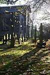 | |||
| Allenvale Road, Allenvale Cemetery, Including Lodge And James Saint Monument | 57°07′51″N 2°06′38″W | Category B | 46473 | | |||
| 1 Fonthill Terrace, Whinhill House, Including Gates, Gatepiers And Boundary Walls | 57°08′08″N 2°06′29″W | Category B | 46476 | | |||
| 60 And 62 Albury Road, Including Boundary Walls | 57°08′17″N 2°06′34″W | Category C(S) | 46770 | | |||
| Duthie Park, East Lodge, Gates, Gatepiers And Boundary Walls | 57°07′56″N 2°06′08″W | Category B | 46779 | | |||
| North Esplanade West, Proserv (Ns) Ltd., Former Caretakers House, Aberdeen Mineral Water Co | 57°08′20″N 2°05′42″W | Category C(S) | 46795 | | |||
| 6-8 (Even Numbers) Polmuir Road, Including Boundary Walls And Railings | 57°08′10″N 2°06′17″W | Category C(S) | 46798 | | |||
| 1, 3 And 3A Beechgrove Terrace And 2 Westfield Road, Including Boundary Walls | 57°08′57″N 2°07′25″W | Category C(S) | 47452 | | |||
| 44 And 46 Fountainhall Road At Desswood Place, Including Boundary Walls | 57°08′43″N 2°07′40″W | Category C(S) | 47479 | | |||
| 20 Hamilton Place, Including Boundary Walls | 57°08′54″N 2°07′26″W | Category C(S) | 47488 | | |||
| Skene Street And Esslemont Avenue, Aberdeen Grammar School, Lodge, Bridge Over Denburn, Gates, Gatepiers, Boundary Walls And Railings | 57°08′46″N 2°06′51″W | Category B | 47494 | | |||
| 514-520 (Even Numbers) Union Street | 57°08′35″N 2°06′45″W | Category C(S) | 47498 | | |||
| 40 Albyn Place, Including Gatepiers And Boundary Walls | 57°08′34″N 2°07′31″W | Category B | 47915 | | |||
| Holburn Street At Alford Lane, Holburn Central Parish Church, Including Church Hall, March Stone (Forming Quoin On W Gable) And Boundary Walls | 57°08′32″N 2°06′45″W | Category B | 47927 | | |||
| 28-38 (Even Numbers) Holburn Street And 4-14 (Even Numbers) Union Grove, Skene House, Including Boundary Wall And Inset Niche | 57°08′32″N 2°06′46″W | Category B | 47929 | | |||
| 338 King Street, Merkland South Building (Former King Street Public School) Including Gatepiers, Gates And Railings | 57°09′18″N 2°05′39″W | Category C(S) | 48284 | | |||
| Newlands Avenue And South Anderson Drive, Newlands, Including Boundary Walls | 57°07′49″N 2°07′42″W | Category C(S) | 48518 | | |||
| 'satrosphere', 179 Constitution Street, Former Tramway Depot | 57°09′12″N 2°05′05″W | Category B | 49309 | | |||
| 60 Frederick Street, Warehouse | 57°09′00″N 2°05′30″W | Category B | 50945 | | |||
| 107-131 (Odd Nos) Union Street | 57°08′47″N 2°05′56″W | Category C(S) | 50958 | | |||
| Greyhope Road, Capstan Jetty | 57°08′28″N 2°04′05″W | Category C(S) | 51752 | | |||
| Spital, 15 And 17 Spital | 57°09′27″N 2°06′00″W | Category B | 51757 | | |||
| Justice Mill Lane, Former Regent Cinema | 57°08′30″N 2°06′41″W | Category C(S) | 45603 | | |||
| 1 And 3 Rubislaw Den South At Spademill Road, Including Boundary Walls | 57°08′33″N 2°08′04″W | Category C(S) | 20788 | | |||
| 27 And 27A Rubislaw Den South, Including Boundary Walls | 57°08′33″N 2°08′14″W | Category C(S) | 20791 | | |||
| 33 And 35 Rubislaw Den South, Including Gatepiers And Boundary Walls | 57°08′32″N 2°08′16″W | Category C(S) | 20793 | | |||
| 30 Rubislaw Den South, Including Gatepiers And Boundary Walls | 57°08′34″N 2°08′19″W | Category B | 20806 | | |||
| 54 Rubislaw Den South, Including Ancillary Structure, Gatepiers And Boundary Walls | 57°08′33″N 2°08′32″W | Category C(S) | 20814 | | |||
| 58 And 58A Rubislaw Den South, Ingleside, Including Gatepiers And Boundary Walls | 57°08′33″N 2°08′34″W | Category B | 20816 | | |||
| 33 Forest Road At Desswood Place, Including Gatepiers And Boundary Walls | 57°08′40″N 2°08′03″W | Category C(S) | 20696 | | |||
| 44, 44A And 46 Forest Road, Including Gatepiers And Boundary Walls | 57°08′42″N 2°08′09″W | Category C(S) | 20705 | | |||
| 19 Queen's Road, Albyn School For Girls, Including Ancillary Structure, Gatepiers And Boundary Walls | 57°08′30″N 2°07′53″W | Category B | 20717 | | |||
| 33 Queen's Road, Including Gatepiers And Boundary Walls | 57°08′28″N 2°08′02″W | Category B | 20723 | | |||
| 2 And 4 Queen's Road, Including Gatepiers And Boundary Walls | 57°08′34″N 2°07′46″W | Category C(S) | 20733 | | |||
| 11 Rubislaw Den North, Braco Lodge, Including Boundary Walls | 57°08′40″N 2°08′17″W | Category C(S) | 20763 | | |||
| 24 Rubislaw Den North, Including Gatepiers And Boundary Walls | 57°08′42″N 2°08′18″W | Category C(S) | 20775 | | |||
| 6 Queen's Gate And 2-12 (Even Numbers) And 12A Forest Road, At Queen's Road, Including Railings And Boundary Walls | 57°08′32″N 2°08′01″W | Category C(S) | 20635 | | |||
| 230 George Street And 34 John Street | 57°09′05″N 2°06′09″W | Category B | 20649 | | |||
| Hazlehead Park, K6 Telephone Kiosk | 57°08′24″N 2°10′26″W | Category B | 20670 | | |||
| Gilcomston South Church Union Street/Summer Street | 57°08′39″N 2°06′32″W | Category B | 20676 | | |||
| 244 Market Street And 1 North Esplanade West, Riverside House, Former Tramshed | 57°08′27″N 2°05′27″W | Category B | 20678 | | |||
| 25 Polmuir Road, Clifton Villa, Including Boundary Walls | 57°08′04″N 2°06′11″W | Category C(S) | 20615 | | |||
| Hamilton Place, Whitehill Bowling Green Wall, Including Piers, Railings And Gates | 57°08′51″N 2°07′37″W | Category B | 20627 | | |||
| 98 Hamilton Place At Fountainhall Road, Including Gatepiers And Boundary Walls | 57°08′50″N 2°07′46″W | Category A | 20629 | 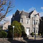 | |||
| 37 And 39 Westburn Road, Including Gatepiers And Boundary Walls | 57°09′11″N 2°06′52″W | Category C(S) | 20597 | | |||
| Wrights' And Coopers' Place (House 4; Old Number 7) | 57°09′59″N 2°06′06″W | Category B | 20602 | | |||
| Union Street, 261-263 | 57°08′39″N 2°06′21″W | Category C(S) | 20538 | | |||
| 431 Union Street Including 429, 433, 441, 443 Union Street, Former Capitol Cinema | 57°08′35″N 2°06′36″W | Category B | 20547 | | |||
| Union Street, 156 | 57°08′44″N 2°06′14″W | Category C(S) | 20562 | | |||
| Union Terrace, 19 Savings Bank And 1 Diamond Place | 57°08′48″N 2°06′15″W | Category B | 20577 | | |||
| 20 And 22 Upperkirkgate | 57°08′56″N 2°05′54″W | Category C(S) | 20580 | | |||
| 42 Upperkirkgate | 57°08′55″N 2°05′56″W | Category C(S) | 20582 | | |||
| St. Machar Drive, 60 Cluny's Port, Old Aberdeen | 57°10′01″N 2°06′11″W | Category B | 20478 | | |||
| St. Machar Drive, 70 Old Aberdeen | 57°10′01″N 2°06′06″W | Category B | 20480 | | |||
| 61 Schoolhill, Former James Dun's House | 57°08′52″N 2°06′04″W | Category B | 20483 | | |||
| 48 And 50 Shiprow (Including Former House Of Provost Ross) | 57°08′48″N 2°05′41″W | Category A | 20484 | 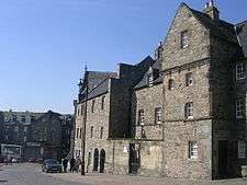 | |||
| Skene Terrace, 44 | 57°08′50″N 2°06′27″W | Category B | 20504 | | |||
| Skene Terrace, 48, 50 | 57°08′50″N 2°06′29″W | Category B | 20506 | | |||
| 95, 97 And 99 Union Street | 57°08′47″N 2°05′54″W | Category C(S) | 20524 | | |||
| 76 Forest Road At King's Gate (Formerly 55 King's Gate), Including Gates, Gatepiers And Boundary Walls | 57°08′48″N 2°08′12″W | Category B | 20416 | | |||
| Mackenzie Place, 8 High Street, Old Aberdeen | 57°09′55″N 2°06′10″W | Category B | 20417 | | |||
| Mackie Place, 4, 5 | 57°08′51″N 2°06′47″W | Category B | 20419 | | |||
| Marine Terrace, Boundary Walls And Railings To Communal Garden, Including Former Public Lavatory | 57°08′19″N 2°06′05″W | Category B | 20422 | | |||
| 11-15 (Odd Nos) Marischal Street | 57°08′51″N 2°05′35″W | Category B | 20424 | | |||
| 56 Marischal Street | 57°08′48″N 2°05′31″W | Category C(S) | 20442 | | |||
| 39 And 40 Regent Quay | 57°08′48″N 2°05′27″W | Category C(S) | 20462 | | |||
| 73, 74 And 75 Regent Quay | 57°08′48″N 2°05′17″W | Category C(S) | 20467 | | |||
| Golden Square, 17, 18 | 57°08′45″N 2°06′21″W | Category B | 20328 | | |||
| Grant's Place, 1-3 Old Aberdeen | 57°09′58″N 2°06′07″W | Category B | 20330 | | |||
| 64, 64A, 66, 66A And 66B Hamilton Place, Including Gatepiers And Boundary Walls | 57°08′52″N 2°07′37″W | Category A | 20335 | .jpg) | |||
| 68, 68A And 70 Hamilton Place, Including Gatepiers And Boundary Walls | 57°08′52″N 2°07′38″W | Category A | 20336 | 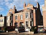 | |||
| 82, 82A And 84 Hamilton Place, Including Gatepiers And Boundary Walls | 57°08′51″N 2°07′42″W | Category A | 20340 | .jpg) | |||
| High Street, 17, 19 (West Side) Old Aberdeen | 57°09′53″N 2°06′08″W | Category B | 20348 | | |||
| High Street, 33, (West Side) Old Aberdeen | 57°09′55″N 2°06′09″W | Category B | 20353 | | |||
| High Street, 67, (West Side) And Thom's Court, Old Aberdeen | 57°09′57″N 2°06′08″W | Category C(S) | 20359 | | |||
| High Street, 81, Garden Walls And Gate Pillars | 57°09′58″N 2°06′08″W | Category B | 20361 | | |||
| High Street, 38-48 (Even Nos) (East Side) Row Part Of Block E Of Taylor Building, King's College, Old Aberdeen | 57°09′55″N 2°06′07″W | Category B | 20368 | | |||
| High Street, 106 (East Side) Old Aberdeen | 57°10′01″N 2°06′07″W | Category B | 20377 | | |||
| 249 Holburn Street | 57°08′13″N 2°06′52″W | Category C(S) | 20379 | | |||
| 2-6 (Even Nos) King Street And 7 And 8 Castle Street | 57°08′55″N 2°05′35″W | Category B | 20394 | | |||
| 12 And 14 King Street | 57°08′55″N 2°05′36″W | Category C(S) | 20395 | | |||
| Don Street, (N.W. Side) Braeside Cottage And Ivy Cottage | 57°10′40″N 2°06′00″W | Category B | 20303 | | |||
| Douglas Place, 6 Old Aberdeen | 57°09′54″N 2°06′10″W | Category B | 20309 | | |||
| 261-265 (Odd) George Street | 57°09′06″N 2°06′12″W | Category B | 20317 | | |||
| 1-5 (Odd Nos) George Street | 57°08′54″N 2°05′58″W | Category B | 20318 | | |||
| George Street, 393 Aberdeen Savings Bank | 57°09′12″N 2°06′20″W | Category B | 20319 | | |||
| George Street, 593-595 | 57°09′22″N 2°06′32″W | Category C(S) | 20321 | | |||
| College Bounds, 51 And 51 And 1/2 (West Side) Powis Lodge Old Aberdeen | 57°09′50″N 2°06′09″W | Category B | 20220 | | |||
| College Bounds, 20, 22 (East Side) Old Aberdeen | 57°09′44″N 2°06′05″W | Category B | 20227 | | |||
| Crown Street, 27, 29 Britannic House | 57°08′39″N 2°06′10″W | Category B | 20241 | | |||
| Crown Street, 84, 86, 86 And A Half | 57°08′36″N 2°06′09″W | Category B | 20250 | | |||
| Dee Place, 13 | 57°08′29″N 2°06′09″W | Category B | 20255 | | |||
| Dee Street, 69, 71 | 57°08′33″N 2°06′10″W | Category B | 20263 | | |||
| Dee Street, 46 | 57°08′36″N 2°06′14″W | Category C(S) | 20266 | | |||
| Don Street, 27, 29 (West Side) Old Aberdeen | 57°10′04″N 2°06′06″W | Category C(S) | 20278 | | |||
| Don Street, 45 (West Side) Old Aberdeen | 57°10′06″N 2°06′03″W | Category B | 20280 | | |||
| Don Street, 49 (The Close) Old Aberdeen | 57°10′06″N 2°06′02″W | Category B | 20281 | | |||
| Don Street, 65, 67 (West Side) Old Aberdeen | 57°10′07″N 2°05′59″W | Category B | 20284 | | |||
| Don Street, 75, 77 (West Side) Old Aberdeen | 57°10′08″N 2°05′57″W | Category C(S) | 20286 | | |||
| 51 And 52 Castle Street And 1 And 3 Marischal Street | 57°08′52″N 2°05′35″W | Category B | 20173 | | |||
| Chanonry (West Side) And St Machar Drive, Botany Boundary Wall And Gate Pillars | 57°10′04″N 2°06′10″W | Category B | 20177 | | |||
| Chanonry, 11 (West Side) Old Aberdeen | 57°10′09″N 2°06′15″W | Category B | 20188 | | |||
| Chanonry, 18 Boundary Wall Only | 57°10′09″N 2°06′03″W | Category B | 20199 | | |||
| Clark's Lane, 3 Old Aberdeen | 57°10′07″N 2°05′55″W | Category B | 20205 | | |||
| 22 And 23 Albyn Place, Albyn Hospital, Including Boundary Walls | 57°08′34″N 2°07′07″W | Category B | 20118 | | |||
| 1-3 (Odd Nos) Bath Street, Royal Hotel | 57°08′41″N 2°06′08″W | Category C(S) | 20124 | | |||
| 30 Beechgrove Terrace, Mile End House, Including Gatepiers And Boundary Walls | 57°08′57″N 2°07′38″W | Category C(S) | 20126 | | |||
| 49 And 51 Belmont Street, The Belmont Picturehouse (Former Trades Council Hall) | 57°08′50″N 2°06′09″W | Category C(S) | 20132 | | |||
| 11A-19 Bon Accord Street (Former Livery Stables And Offices), 21-29 Langstane Place And 2-16 Gordon Street | 57°08′38″N 2°06′21″W | Category B | 20139 | | |||
| Bon Accord Street, 60, 62 | 57°08′31″N 2°06′18″W | Category C(S) | 20148 | | |||
| 2 Alford Place, Alford Place Church (Former Christ's College Library), Including Wall And Railings | 57°08′35″N 2°06′45″W | Category B | 20087 | | |||
| Powis House, (Powis Community Centre) 11 Powis Circle | 57°09′51″N 2°06′35″W | Category B | 20104 | | |||
| 35 Regent Quay, Custom House | 57°08′47″N 2°05′28″W | Category A | 19982 | .jpg) | |||
| 27,29,31 King Street, Including Railings | 57°08′56″N 2°05′38″W | Category A | 19983 | .jpg) | |||
| Fire Station (North Eastern Fire Brigade Area Headquarters), King Street | 57°09′12″N 2°05′39″W | Category B | 19985 |  | |||
| Castle Street And 2 Broad Street, Town House, Including Municipal Offices, Court Houses And Tolbooth | 57°08′53″N 2°05′41″W | Category A | 19990 |  | |||
| Telephone Exchange 27-35 (Odd Nos) Bon Accord Street | 57°08′36″N 2°06′18″W | Category B | 19997 | | |||
| Queen's Cross, Queen Victoria Statue | 57°08′35″N 2°07′37″W | Category B | 20011 | | |||
| 115-117 (Odd Numbers) Great Western Road, March Stone Number 4 | 57°08′19″N 2°07′06″W | Category C(S) | 20017 | | |||
| March Stone No. 7, At No. 3 Craigton Road | 57°07′54″N 2°08′17″W | Category B | 20020 | | |||
| March Stone No. 47 On North Side Of The Road Leading To Farm Of Westerton Of Auchmill And At The Bend North Of Marchburn Infant School | 57°10′14″N 2°10′00″W | Category B | 20027 | | |||
| 55 Powis Terrace, March Stone No 57 | 57°09′36″N 2°06′51″W | Category C(S) | 20037 | | |||
| March Stone No. 58, In Front Garden Wall Of 21 Elmbank Terrace | 57°09′29″N 2°06′29″W | Category B | 20038 | | |||
| March Stone No. 64, On South Side Of School Road At Junction With Golf Road | 57°09′59″N 2°05′14″W | Category B | 20044 | | |||
| 24 Albyn Place, St John's Well | 57°08′52″N 2°06′32″W | Category C(S) | 20054 | | |||
| Snow Churchyard College Bounds | 57°09′46″N 2°06′09″W | Category B | 20064 | | |||
| Brig O' Balgownie Over River Don | 57°10′38″N 2°05′55″W | Category A | 20067 | 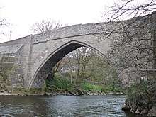 | |||
| Duthie Park, Fountainhall Cistern House | 57°07′43″N 2°06′15″W | Category C(S) | 20080 | | |||
| Carden Place And Albyn Place, Queen's Cross Church (Church Of Scotland), Including Gatepiers And Boundary Walls | 57°08′36″N 2°07′30″W | Category A | 19948 | .jpg) | |||
| King Street, St Andrew's Cathedral (Episcopal) | 57°08′57″N 2°05′35″W | Category A | 19953 |  | |||
| 15 Back Wynd (Former West St Nicholas Church Parish Rooms) | 57°08′51″N 2°06′02″W | Category C(S) | 19968 | | |||
| 20 Union Terrace | 57°08′48″N 2°06′16″W | Category B | 19979 | | |||
| 5 York Street, Cam House, (Former Nursery School), Including Boundary Wall And Railings | 57°08′47″N 2°04′45″W | Category C(S) | 46278 | | |||
| 17 Fonthill Road, Eastbank, Including Gatepiers And Boundary Walls | 57°08′13″N 2°06′29″W | Category C(S) | 46475 | | |||
| 2-14 (Even Numbers) Fonthill Terrace, Including Gatepiers And Boundary Walls | 57°08′09″N 2°06′28″W | Category B | 46477 | | |||
| Duthie Park, Fountain | 57°07′47″N 2°06′04″W | Category B | 46781 | | |||
| 32-36 (Even Numbers) Ferryhill Place, Including Gatepiers And Boundary Walls | 57°08′14″N 2°06′14″W | Category B | 46788 | | |||
| 64 Fonthill Road And 73-75 (Odd Numbers) Albury Road | 57°08′14″N 2°06′34″W | Category C(S) | 46790 | | |||
| 6 Berryden Road | 57°09′13″N 2°06′43″W | Category C(S) | 46983 | | |||
| 82 Beechgrove Terrace, Ernan Lodge, Including Boundary Walls | 57°08′53″N 2°07′48″W | Category C(S) | 46992 | | |||
| Mid Stocket Road, Raeden Nursery Walled Garden | 57°09′02″N 2°08′35″W | Category C(S) | 46995 | | |||
| 172-176 (Inclusive Numbers) And 178 Skene Street At Thistle Lane, Including Boundary Walls | 57°08′45″N 2°06′49″W | Category C(S) | 47496 | | |||
| 21 Albyn Place, Albyn Hospital, Including Boundary Walls | 57°08′34″N 2°07′06″W | Category C(S) | 47912 | | |||
| 67 King's Gate, Including Boundary Walls | 57°08′47″N 2°08′22″W | Category C(S) | 47930 | | |||
| Broomhill Road At Gray Street, Broomhill Primary School, Including Gates, Gatepiers, Boundary Walls, Railings And Lodge (88 Gray Street) | 57°07′55″N 2°07′27″W | Category C(S) | 48513 | | |||
| Union Grove At Holburn Street, 1-18 (Inclusive Numbers) Union Grove Court, Including Gatepiers And Boundary Walls | 57°08′30″N 2°06′48″W | Category C(S) | 48523 | |
Key
The scheme for classifying buildings in Scotland is:
- Category A: "buildings of national or international importance, either architectural or historic; or fine, little-altered examples of some particular period, style or building type."[1]
- Category B: "buildings of regional or more than local importance; or major examples of some particular period, style or building type, which may have been altered."[1]
- Category C: "buildings of local importance; lesser examples of any period, style, or building type, as originally constructed or moderately altered; and simple traditional buildings which group well with other listed buildings."[1]
In March 2016 there were 47,288 listed buildings in Scotland. Of these, 8 per cent were Category A, and 50 per cent were Category B, with the rest listed at Category C.[2]
See also
Notes
- Sometimes known as OSGB36, the grid reference (where provided) is based on the British national grid reference system used by the Ordnance Survey.
• "Guide to National Grid". Ordnance Survey. Retrieved 12 December 2007.
• "Get-a-map". Ordnance Survey. Retrieved 17 December 2007. - Historic Environment Scotland assign a unique alphanumeric identifier to each designated site in Scotland, for listed buildings this always begins with "LB", for example "LB12345".
References
- All entries, addresses and coordinates are based on data from Historic Scotland. This data falls under the Open Government Licence
- "What is Listing?". Historic Environment Scotland. Retrieved 29 May 2018.
- Scotland's Historic Environment Audit 2016 (PDF). Historic Environment Scotland and the Built Environment Forum Scotland. pp. 15–16. Retrieved 29 May 2018.
This article is issued from Wikipedia. The text is licensed under Creative Commons - Attribution - Sharealike. Additional terms may apply for the media files.