List of lighthouses in Chile: NGA1328–NGA1540
Robinson Crusoe Island
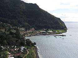
Bahía Cumberland.

Cabo Carranza Lighthouse, also named Río Loanco.
| It. | NGA/Int number |
Location | Coordinates | Light characteristic |
Height (ft/m) Range (nmi) |
Structure description |
Height (ft) | Remarks |
|---|---|---|---|---|---|---|---|---|
| 187 | 1328 G 1855 |
Punta San Carlos. | 33°37.9′S 78°49.7′W | Fl.W. period 12s fl. 1s, ec. 11s | 18 6 9 | White fiberglass tower, red band; | 11. | Visible 180°-001°. |
| 188 | 1330 G 1856 |
Bahía Cumberland. | 33°38.2′S 78°49.7′W | Fl.G. period 5s fl. 1s, ec. 4s | 16 5 3 | Green metal framework tower; | 10. | Visible 184°-279°. |
| 189 | 1331 G 1856.2 |
Bahía Padre. | 33°40.0′S 78°55.9′W | Fl.W. period 5s fl. 0.4s, ec. 4.6s | 20 6 8 | White metal framework tower, red band; | 10. | |
| 190 | 1331.5 G 1853 |
Isla Alejandro Selkirk. | 33°43.6′S 80°46.4′W | Fl.W. period 10s fl. 1s, ec. 9s | 30 9 3 | White fiberglass tower, red band; | 11. | Visible 141°-351°. |
| 191 | 1332 G 1850 |
Punta Topocalma. | 34°08.0′S 72°01.0′W | Fl.W. period 10s fl. 0.3s, ec. 9.7s | 387 118 16 | White fiberglass tower, red band; | 13. | Visible 347°-210°. |
| 192 | 1334 G 1848 |
Trilco, Punta Cardonal. | 34°48.8′S 72°08.2′W | Fl.W. period 5s fl. 1s, ec. 4s | 148 45 9 | White building, red band; | 22. | Visible 037°-202°. |
| 193 | 1335 G 1846.5 |
Muelle Maguellines. | 35°21.5′S 72°27.8′W | Fl.W. period 5s fl. 1s, ec. 4s | 20 6 4 | White metal post, red band; | 10. | |
| 194 | 1336 G 1846 |
Cabo Carranza. | 35°33.4′S 72°36.8′W | Fl.W. period 10s fl. 1.5s, ec. 8.5s | 171 52 21 | White square metal tower, red bands; | 62. | Visible 038°-211°. Aero Radiobeacon 19.8 miles NNE marked by Fl.R. |
| 195 | 1340 | Bahía Cobquecura. | 36°09.0′S 72°48.0′W | F.W. | 10 | Several F.W. lights. | ||
| 196 | 1344 G 1797 |
Morro Lobería. | 36°34.4′S 72°59.9′W | Fl.W. period 10s fl. 0.5s, ec. 9.5s | 262 80 9 | White fiberglass tower, red band; | 13. | Visible 332°-200°. |
| 197 | 1348 G 1798 |
Isla Quiriquina. | 36°36.6′S 73°03.1′W | Fl.W. period 10s fl. 0.2s, ec. 9.8s | 295 90 21 | White metal tower, red band; | 23. | Visible 048°-015°. Siren: 2 bl. ev. 30s (bl. 2s, si. 3s, bl. 2s, si. 23s). |
| 198 | 1352 G 1806 |
Punta Arenas. | 36°38.3′S 73°03.2′W | Fl.(3)W. period 9s fl. 0.5s, ec. 1.5s fl. 0.5s, ec. 1.5s fl. 0.5s, ec. 4.5s | 26 8 6 | White metal post, red band; | 21. | Visible 192°-035°. |
| 199 | 1353 G 1806.5 |
N. Measured Mile Range, front. | 36°37.8′S 73°03.0′W | F.W. | 57 18 3 | White fiberglass tower, red band; | 21. | Visible 301° 30′ -311° 30′ . Q.W. 3M shown to assist identification. Occasional. |
| 200 | 1353.1 G 1806.51 |
Rear, 624 meters 305° 30′ from front. | 36°37.4′S 73°03.4′W | F.W. | 172 52 3 | White fiberglass tower, red band; | 21. | Visible 301° 30′ -311° 30′ . Occasional. |
| 201 | 1354 G 1806.6 |
S. Measured Mile Range, front. | 36°38.6′S 73°03.7′W | F.W. | 169 52 3 | White fiberglass tower, red band; | 21. | Visible 301° 30′ -311° 30′ . Q.W. 3M shown to assist identification. Occasional. |
| 202 | 1354.1 G 1806.61 |
Rear, 77 meters 305° 30′ from front. | 36°38.4′S 73°03.9′W | F.W. | 179 54 3 | White fiberglass tower, red band; | 21. | Visible 301° 30′ -311° 30′ . Occasional. |
| 203 | 1360 G 1802 |
N. mole, head. | 36°38.1′S 73°03.2′W | Fl.R. period 3s fl. 0.4s, ec. 2.6s | 16 5 3 | Red metal pillar; | 6. | |
| 204 | 1364 G 1808 |
S. mole, head. | 36°38.7′S 73°03.8′W | Fl.W. period 8s fl. 3s, ec. 5s | 16 5 6 | White round metal post, red band; | 11. | Visible 255°-053°. |
| 205 | 1376 G 1833 |
Penco mechanized pier, head. | 36°43.1′S 73°00.4′W | Fl.R.G. period 2s fl. 0.4s, ec. 1.6s | R. 6 G. 4 | G. E. side, R. W. side. Private light. | ||
| 206 | 1380 G 1830 |
Isla de los Reyes E, front. | 36°43.6′S 73°02.6′W | F.R. | 44 14 6 | White metal post, red band, white diamond daymark, orange stripe; | 20. | Private light. |
| 207 | 1380.1 G 1830.1 |
Rear D, 300 meters 258° from front. | 36°43.7′S 73°03.6′W | F.R. | 80 24 6 | White metal post, red band, white diamond daymark, orange stripe; | 56. | Private light. |
Talcahuano
| It. | NGA/Int number |
Location | Coordinates | Light characteristic |
Height (ft/m) Range (nmi) |
Structure description |
Height (ft) | Remarks |
|---|---|---|---|---|---|---|---|---|
| 208 | 1384 G 1820 |
Repair basin, breakwater, head. | 36°41.7′S 73°06.2′W | Fl.(4)R. period 12s fl. 0.8s, ec. 1.2s fl. 0.8s, ec. 1.2s fl. 0.8s, ec. 1.2s fl. 0.8s, ec. 5.2s | 20 6 4 | Red metal tower, triangular daymark; | 10. | |
| 209 | 1385 G 1823 |
Range, front, SE. of spit. | 36°42.5′S 73°06.3′W | F.R. | 65 20 11 | Red metal tower; | 5. | Occasional. Private light. |
| 210 | 1385.5 G 1823.1 |
Rear, about 107 meters 241° from front. | 36°42.5′S 73°06.3′W | F.G. | 85 26 11 | Metal tower, red and green stripes, triangular daymark; | 20. | Occasional. Private light. |
| 211 | 1386 G 1824 |
Range B, front, E. side of pier. | 36°42.6′S 73°06.3′W | F.R. | 26 8 11 | Metal tower, red and green stripes, triangular daymark; | 20. | Occasional. Private light. |
| 212 | 1386.5 G 1824.1 |
Rear, about 396 meters 195° from front. | 36°42.9′S 73°06.4′W | F.G. | 98 30 11 | Metal tower, red and green stripes, triangular daymark; | 20. | Occasional. Private light. |
| 213 | 1388 G 1821 |
W. breakwater, head. | 36°41.7′S 73°06.3′W | Fl.(4)G. period 12s fl. 0.8s, ec. 1.2s fl. 0.8s, ec. 1.2s fl. 0.8s, ec. 1.2s fl. 0.8s, ec. 5.2s | 20 6 4 | Green metal tower, rectangular daymark; | 10. | |
| 214 | 1390 G 1834 |
Puerto Lirquén, Muelle No. 1. | 36°42.2′S 72°58.9′W | Fl.G. period 3s fl. 0.3s, ec. 2.7s | 31 10 5 | Green round metal tower; | 13. | Visible 070°-249°. Numerous lighted range beacons mark approaches to port and vicinity. |
| 215 | 1391 G 1834.5 |
Muelle No. 2. | 36°42.4′S 72°59.4′W | Fl.R. period 3s fl. 0.3s, ec. 2.7s | 33 10 5 | Red round metal tower; | 15. | Visible 079°-258°. |
| 216 | 1392 G 1816 |
Marinao breakwater. | 36°41.8′S 73°05.6′W | Fl.(3)R. period 9s fl. 0.5s, ec. 1.5s fl. 0.5s, ec. 1.5s fl. 0.5s, ec. 4.5s | 18 6 4 | Red metal post, triangular daymark; | 10. | |
| 217 | 1396 G 1814 |
Belén Shoal. -RACON |
36°41.8′S 73°05.0′W | Fl.(3)W. period 10s fl. 0.2s, ec. 1.2s fl. 0.2s, ec. 1.2s fl. 0.2s, ec. 7s B(– • • •) period 60s 4 |
36 11 9 | E. CARDINAL BYB, beacon, topmark; | 26. | Radar reflector. |
| 218 | 1399 G 1821.5 |
Cabeza Muelle Fogonero. | 36°41.8′S 73°06.0′W | Fl.W. period 5s fl. 0.4s, ec. 4.6s | 20 6 6 | White round metal tower, red band; | 12. | Visible 267°-097°. |
| 219 | 1400 G 1812 |
Caleta Manzano, mole. | 36°41.3′S 73°06.0′W | Fl.R. period 5s fl. 1s, ec. 4s | 16 5 4 | Red metal triangular tower; | 10. |
Bahía San Vicente
| It. | NGA/Int number |
Location | Coordinates | Light characteristic |
Height (ft/m) Range (nmi) |
Structure description |
Height (ft) | Remarks |
|---|---|---|---|---|---|---|---|---|
| 220 | 1408 G 1796 |
Punta Tumbes. | 36°36.7′S 73°07.0′W | Fl.W. period 5s fl. 0.3s, ec. 4.7s | 128 39 18 | White round metal tower, red bands; | 21. | Visible 028°-273°. |
| 221 | 1409 G 1795.75 |
Malecón de Atraque, terminal. | 36°43.6′S 73°08.1′W | F.R. | 46 14 2 | Red metal triangular tower; | 7. | Visible 355°-025°. Private light. |
| 222 | 1411 G 1795.7 |
Range, front. | 36°43.6′S 73°08.1′W | F.G. | 33 10 2 | Red metal triangular tower; | 7. | Visible 355°-025°. Private light. |
| 223 | 1411.5 G 1795.71 |
-Rear, about 38 meters 010° from front. | 36°43.6′S 73°08.1′W | F.R. | 46 14 2 | 7. | Visible 355°-025°. Private light. | |
| 224 | 1412 G 1795 |
C.A.P. Muelle, head. | 36°44.4′S 73°07.9′W | Fl.W. period 10s fl. 1s, ec. 9s | 23 7 7 | White metal tower, red band; | 10. | Private light. |
| 225 | 1414 G 1795.2 |
Aproximación sitio Sur Range, front. | 36°44.2′S 73°07.6′W | Fl.G. period 3s fl. 1s, ec. 2s | 52 16 7 | Metal tower, white triangular daymark, orange stripe; | 46. | Private light. |
| 226 | 1414.5 G 1795.21 |
Rear, about 115 meters 048° from front. | 36°44.1′S 73°07.5′W | Fl.G. period 3s fl. 1s, ec. 2s | 62 19 7 | Metal tower, white and orange stripe, triangular daymark; | 46. | Private light. |
| 227 | 1415 G 1795.3 |
Enfilación de fondeo Sitio Norte Range, front. | 36°44.4′S 73°07.5′W | F.G. | 85 26 8 | Metal tower, white and orange stripe, triangular daymark; | 46. | Private light. |
| 228 | 1415.5 G 1795.31 |
Rear, about 184 meters 113° from front. | 36°44.5′S 73°07.4′W | F.G. | 125 38 8 | Metal tower, white and orange stripe, triangular daymark; | 46. | Private light. |
| 229 | 1416 G 1795.5 |
Enfilación de fondeo Sitio Sur Range, front. | 36°44.5′S 73°07.6′W | F.R. | 30 9 8 | Metal tower on shed, white and orange stripe, triangular daymark; | 19. | Private light. |
| 230 | 1416.5 G 1795.51 |
Rear, about 76 meters 097° from front. | 36°44.5′S 73°07.6′W | F.R. | 46 14 8 | Chimney, white and orange stripe, triangular daymark; | 33. | Private light. |
| 231 | 1417 G 1795.4 |
Enfilación de aproximación Sitio Sur Range, front. | 36°44.8′S 73°07.8′W | Fl.R. period 3s fl. 1s, ec. 2s | 52 16 7 | Metal tower, white and orange stripe, triangular daymark; | 46. | Private light. |
| 232 | 1417.5 G 1795.41 |
Rear, about 128 meters 170° from front. | 36°44.9′S 73°07.8′W | Fl.R. period 3s fl. 1s, ec. 2s | 62 19 7 | Metal tower, white and orange stripe, triangular daymark; | 46. | Private light. |
| 233 | 1418 G 1826 |
AVIATION LIGHT. | 36°46.2′S 73°03.7′W | Al.Fl.W.G. | ||||
| 234 | 1420 G 1794 |
Punta Hualpén. | 36°44.6′S 73°11.3′W | Fl.W. period 5s fl. 0.1s, ec. 4.9s | 154 47 19 | White fiberglass tower, red band; | 16. | Visible 040°-262°. Siren: 2 bl. ev. 30s (bl. 5s, si. 10s, bl. 5s, si. 10s). |
| 235 | 1424 G 1764 |
Isla Santa María. | 36°59.0′S 73°32.0′W | Fl.W. period 15s fl. 0.2s, ec. 14.8s | 239 73 11 | White fiberglass tower, red band; | 26. | Visible 006°-344°. |
| 236 | 1428 G 1765 |
Punta Delicada. | 37°02.1′S 73°28.3′W | Fl.W. period 10s fl. 0.7s, ec. 9.3s | 30 9 7 | White fiberglass tower, red band; | 13. | Visible 151°-045°. |
Bahía de Coronel
| It. | NGA/Int number |
Location | Coordinates | Light characteristic |
Height (ft/m) Range (nmi) |
Structure description |
Height (ft) | Remarks |
|---|---|---|---|---|---|---|---|---|
| 237 | 1432 G 1784 |
Punta Puchoco. | 37°01.5′S 73°10.4′W | Fl.W. period 10s fl. 1.3s, ec. 8.7s | 62 19 20 | White fiberglass tower, red band; | 20. | Visible 262°-140°. |
| 238 | 1432.1 G 1783.5 |
Range, front. | 37°01.5′S 73°10.4′W | F.R. | 58 18 7 | White iron tower, red stripe, white triangular daymark, orange stripes; | 32. | |
| 239 | 1432.2 G 1783.6 |
Rear, 112.4 meters 349° from front. | 37°01.5′S 73°10.4′W | F.R. | 67 20 7 | White iron tower, red stripe, white triangular daymark, orange stripes; | 42. | |
| 240 | 1436 G 1782.5 |
Muelle Puerto Coronel. | 37°01.6′S 73°09.0′W | Fl.W. period 5s fl. 0.4s, ec. 4.6s | 31 9 8 | White tower, red bands; | 31. | Visible 320°-140°. |
| 241 | 1438 G 1783 |
Approach Range, front. | 37°01.3′S 73°09.5′W | F.G. | 49 15 4 | White column, red bands, white triangular daymark, orange stripes; | 49. | Visible 235°-055°. |
| 242 | 1438.1 G 1783.1 |
Rear, 80 meters 325° from front. | 37°01.2′S 73°09.5′W | F.G. | 69 21 4 | White column, red bands, white triangular daymark, orange stripes; | 69. | Visible 235°-055°. |
| 243 | 1440 G 1782.6 |
N. Approach Range, front. | 37°01.4′S 73°08.8′W | F.G. | 49 15 7 | White column, red bands, white triangular daymark, orange stripes; | 43. | Visible 320°-140°. |
| 244 | 1440.1 G 1782.7 |
Rear, 160 meters 050° from front. | 37°01.3′S 73°08.7′W | F.G. | 52 16 7 | White column, red bands, white triangular daymark, orange stripes; | 59. | Visible 320°-140°. |
| 245 | 1442 G 1782.8 |
S. Approach Range, front. | 37°01.5′S 73°08.7′W | F.R. | 51 16 7 | White metal column, red bands, white triangular daymark, orange stripes; | 59. | Visible 320°-140°. |
| 246 | 1442.1 G 1782.9 |
Rear, 160 meters 050° from front. | 37°01.4′S 73°08.6′W | F.R. | 69 21 7 | White triangular daymark, orange stripes, on roof of shed; | 10. | Visible 320°-140°. |
| 247 | 1443 G 1782.3 |
Range, front. | 37°01.9′S 73°08.8′W | Q.R. | 62 19 7 | White iron tower, red stripe, white triangular daymark, orange stripes; | 44. | |
| 248 | 1443.1 G 1782.31 |
Rear, 172.5 meters 077° from front. | 37°01.8′S 73°08.7′W | Q.R. | 81 25 7 | White iron tower, red stripe, white triangular daymark, orange stripes; | 57. |
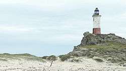
Bahía de Lota
.jpg)
Lighthouse in Lota
| It. | NGA/Int number |
Location | Coordinates | Light characteristic |
Height (ft/m) Range (nmi) |
Structure description |
Height (ft) | Remarks |
|---|---|---|---|---|---|---|---|---|
| 249 | 1452 G 1768 |
Punta Lutrín. | 37°05.4′S 73°10.0′W | Fl.W. period 5s fl. 0.4s, ec. 4.6s | 160 49 8 | White metal tower, red band; | 44. | Visible 250°-186°. |
| 250 | 1476 G 1762 |
Punta Lavapié. | 37°08.8′S 73°34.9′W | Fl.W. period 12s fl. 0.5s, ec. 11.5s | 187 57 8 | White fiberglass tower, red band; | 13. | Visible 055°-272°. |
Lebu
| It. | NGA/Int number |
Location | Coordinates | Light characteristic |
Height (ft/m) Range (nmi) |
Structure description |
Height (ft) | Remarks |
|---|---|---|---|---|---|---|---|---|
| 251 | 1480 G 1758 |
Punta Tucapel. | 37°37.0′S 73°40.0′W | Fl.W. period 12s fl. 0.5s, ec. 11.5s | 26 8 10 | White fiberglass tower, red band; | 13. | Visible 030°-305°. |
| 252 | 1484 G 1756 |
Punta Morguilla. | 37°44.0′S 73°41.0′W | Fl.W. period 10s fl. 0.5s, ec. 9.5s | 98 30 8 | White tower, red band; | 13. | Visible 328°-172°. |
| 253 | 1486 G 1754 |
Tirúa Inlet. | 39°20.0′S 73°30.0′W | Fl.W. period 10s fl. 0.5s, ec. 9.5s | 197 60 8 | White fiberglass tower, red bands; | 11. | Visible 055°-270°. |
| 254 | 1487 G 1755 |
Caleta Quidico. | 38°14.2′S 73°29.4′W | Fl.W. period 5s fl. 1s, ec. 4s | 79 24 6 | White fiberglass tower, red band; | 11. | Visible 043°-270°. |
Isla Mocha
Mocha Island lighthouse.
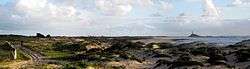
Mocha Island lighthouse.
| It. | NGA/Int number |
Location | Coordinates | Light characteristic |
Height (ft/m) Range (nmi) |
Structure description |
Height (ft) | Remarks |
|---|---|---|---|---|---|---|---|---|
| 255 | 1488 G 1752 |
N. on Cerro Los Chinos. | 38°20.0′S 73°57.0′W | Fl.W. period 5s fl. 0.1s, ec. 4.9s | 220 67 14 | White fiberglass tower, red band; | 26. | Visible 014°-287°. |
| 256 | 1490 | Mocha Weste. | 38°22.1′S 73°57.4′W | Fl.W. period 15s fl. 0.3s, ec. 14.7s | 98 30 15 | White concrete tower, red band; | 42. | Visible 021°-159°. |
| 257 | 1492 G 1750 |
Mocha Sur. | 38°24.7′S 73°53.5′W | Fl.W. period 10s fl. 1s, ec. 9s | 108 33 11 | White fiberglass tower, red bands; | 26. | Visible 205°-063°. |
| 258 | 1494 | Roca en Barra. | 39°26.7′S 73°12.6′W | Fl.G. period 5s fl. 0.5s, ec. 4.5s | 15 4 3 | Green metal pole, green rectangular daymark; | 15. | |
| 259 | 1495 G 1745.4 |
Barra Río Lingue. | 39°26.8′S 73°13.6′W | Fl.R. period 5s fl. 0.5s, ec. 4.5s | 16 5 3 | Red metal pole, red triangular daymark; | 13. | Visible 095°-268°. |
| 260 | 1496 G 1747 |
Caleta Queule, on Punta Ronca. | 39°22.8′S 73°13.5′W | Fl.W. period 5s fl. 0.4s, ec. 4.6s | 164 50 6 | White metal framework tower, red band; | 13. | Visible 065°-320°. |
| 261 | 1497 | La Barra. | 39°23.1′S 73°13.2′W | Fl.G. period 5s fl. 1s, ec. 4s | 16 5 2 | PORT (B) G, tower; | 16. | |
| 262 | 1498 | Roca Queule. | 39°23.2′S 73°13.1′W | Fl.G. period 3s fl. 0.3s, ec. 2.7s | 13 4 2 | PORT (B) G, tower; | 13. | |
| 263 | 1499 | Punta Cuartel. | 39°23.2′S 73°13.1′W | Fl.R. period 5s fl. 1s, ec. 4s | 16 5 2 | STARBOARD (B) R, tower; | 13. | |
| 264 | 1500 G 1744 |
Morro Bonifacio. | 39°41.5′S 73°24.0′W | Fl.W. period 10s fl. 0.7s, ec. 9.3s | 144 44 14 | White concrete tower, red band; | 13. | Visible 014°-208°. |
Bahía Corral

Lighthouse in Niebla, Chile at the Valdivia River
| It. | NGA/Int number |
Location | Coordinates | Light characteristic |
Height (ft/m) Range (nmi) |
Structure description |
Height (ft) | Remarks |
|---|---|---|---|---|---|---|---|---|
| 265 | 1504 G 1728 |
Morro Niebla, E. side of entrance to bay. | 39°51.9′S 73°24.0′W | Fl.W. period 10s fl. 0.3s, ec. 9.7s | 171 52 7 | White iron tower, red band; | 33. | Visible 343°-210°. |
| 266 | 1508 G 1730 |
Roca el Conde, W. side of bay. | 39°52.1′S 73°25.2′W | Fl.R. period 5s fl. 1s, ec. 4s | 20 6 6 | STARBOARD (B) R, fiberglass tower; | 13. | Visible 147°-006°. |
| 267 | 1516 G 1734 |
Corral, Muelle Fiscal de Pasajeros, head. | 39°53.0′S 73°25.5′W | Fl.(2)R. period 6s fl. 0.3s, ec. 1.7s fl. 0.3s, ec. 3.7s | 20 6 6 | Red fiberglass pillar; | 9. | Visible 212°-307°. |
| 268 | 1520 G 1736 |
Isla Mancera, N. end. | 39°52.9′S 73°23.5′W | Fl.(3)R. period 9s fl. 0.3s, ec. 1s fl. 0.3s, ec. 1s fl. 0.3s, ec. 6.1s | 19 6 3 | Red conical fiberglass pillar; | 7. | Visible 043°-309°. |
| 269 | 1524 G 1736.4 |
Muelle Isla Mancera. | 39°53.1′S 73°23.2′W | Fl.R. period 3s fl. 0.3s, ec. 2.7s | 26 8 2 | Red metal tower, red triangular daymark; | 13. | Visible 132°-341°. |
| 270 | 1528 G 1737.4 |
Muelle Niebla No. 2. | 39°52.3′S 73°23.0′W | Fl.G. period 5s fl. 1s, ec. 4s | 20 6 3 | Green metal post; | 13. | Visible 219°-086°. |
| 271 | 1532 G 1726 |
Morro Gonzalo. | 39°50.9′S 73°28.0′W | Fl.W. period 5s fl. 0.4s, ec. 4.6s | 144 44 10 | White square concrete tower, red band; | 13. | Visible 026°-272°. |
| 272 | 1536 G 1724 |
Punta Galera. | 40°00.0′S 73°42.0′W | Fl.W. period 12s fl. 0.4s, ec. 11.6s | 141 43 15 | White fiberglass tower, red band; | 13. | Visible 326°-208°. |
| 273 | 1538 G 1722 |
Caleta Mansa, Punta Moquegua. | 40°35.0′S 73°44.5′W | Fl.W. period 10s fl. 1s, ec. 9s | 167 51 9 | White fiberglass tower, red band; | 13. | Visible 330°-236°. |
| 274 | 1540 G 1720 |
Cabo Quedal. | 40°59.0′S 73°56.5′W | Fl.W. period 15s fl. 0.5s, ec. 14.5s | 269 82 16 | White fiberglass tower, red band; | 13. | Visible 356°-196°. |
References

Lists of lighthouses and lightvessels in Chile | |
|---|---|
| Arica to Isla de Pascua |
|
| Huasco to San Antonio |
|
| Isla Robinson Crusoe to Bahía Corral |
|
| Canal de Chacao to Canal Dalcahue |
|
| Golfo Corcovado to Canal Darwin |
|
| Canal Messier to Canal Smyth |
|
| Estrecho de Magallanes to Paso Picton |
|
This article is issued from Wikipedia. The text is licensed under Creative Commons - Attribution - Sharealike. Additional terms may apply for the media files.