List of crossings of the River Derwent, Derbyshire
This is a list of crossings of the Derbyshire Derwent, the principal river of Derbyshire in the Midlands of England.
Listed in the table are those crossings that have been identified from the first formal crossing at the packhorse bridge at Slippery Stones, in the upper Derwent valley, continuing through the Derwent Valley Mills heritage site to Derby, to the last crossing near Church Wilne upstream of Derwent Mouth where the Derwent meets the River Trent.[1]
Described by Defoe in 1726 as a "fury of a river" the Derwent could only be forded at a number of particular locations, which could still be impassable during winter floods.[2] Wooden bridges provided for a more reliable crossing, but were easily damaged by those same floods. The wooden bridge at Leadmill was destroyed before it was completed in the early 1700s.[3] Toad-Moor Bridge near Ambergate was rebuilt as Halfpenny Bridge by Francis Hurt in 1792, after being swept away in a flood of 1791. In the Candlemas flood of February 1795, the bridges at Belper and Whatstandwell were washed away, but were subsequently rebuilt soon after.[4][5]
Glover in his History of the County of Derby of 1829 noted that there were a number of bridges, fords and a ferry across the Derwent. There were fords at Wilne Mills, Alvaston, Little Eaton and Ambaston, and a ferry at Matlock Bath. Wooden bridges were mentioned at Wilne Mills, Borrowash Mills and Exeter Bridge, downstream of which was a long wooden bridge for canal towing horses. Tolls were levied at Wilne Mills, Darley Abbey, and Milford, where there was also a chain-bridge for mill workers. He also recorded a number of county bridges and stone-arched bridges the majority of which are now listed structures, and in some cases scheduled monuments. A number of these bridges were built by the local industrial families of the Derwent valley, including those of Hurt, Strutt and Evans.[4]
Crossings
| Status | Criteria[6] |
|---|---|
| I | Grade I listed. Bridge of exceptional interest, sometimes considered to be internationally important |
| II* | Grade II* listed. Particularly important bridge of more than special interest |
| II | Grade II listed. Bridge of national importance and special interest |
| Scheduled Monument. Nationally important archaeological bridge. |
| River order | Name | Image | Location Coordinates |
Carries | Date | Heritage status |
Notes |
|---|---|---|---|---|---|---|---|
| 1 | Slippery Stones packhorse bridge | 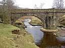 | Hope Woodlands 53.45260°N 1.74661°W | Footpath | 1672 (1959) |
II | A 17th century packhorse bridge that was relocated from Derwent village[7][8] |
| 2 | Howden Dam | 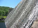 | Howden Reservoir 53.43333°N 1.75000°W | – | 1912 | II | For information[9] |
| 3 | Derwent Dam |  | Derwent Reservoir 53.40503°N 1.74167°W | – | 1916 | II | For information[9] |
| 4 | Fairholmes Bridge | .jpg) | Derwent Reservoir 53.40260°N 1.74219°W | Derwent Lane | - | Stone arch bridge[10] | |
| 5 | Ashopton Viaduct |  | Ladybower Reservoir 53.37465°N 1.71147°W | A57 | 1943 | - | Concrete viaduct[10] |
| 6 | Ladybower Dam | 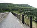 | Ladybower Reservoir 53.3657°N 1.7011°W | Footpath | 1943 | - | Footway along dam wall[11] |
| 7 | Yorkshire Bridge | 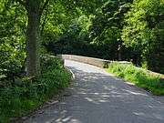 | Yorkshire Bridge 53.36123°N 1.70386°W | Lydgate Lane | 1800s | II | Stone arch bridge[11][12] |
| 8 | Bamford Mill footbridge | .jpg) | Bamford 53.34659°N 1.69411°W | Footpath | - | Wooden footbridge at Bamford Mill[13] | |
| 9 | Water Lane bridge | .jpg) | Bamford 53.34284°N 1.69273°W | Water Lane | - | Minor road bridge[13] | |
| 10 | Railway bridge | Bamford 53.34014°N 1.69230°W | Hope Valley line | - | Rail bridge[13] | ||
| 11 | Mytham Bridge | .jpg) | Bamford 53.33917°N 1.69388°W | A6187 | - | Stone arch bridge with adjacent footbridge[13] | |
| 12 | Hathersage stepping stones | 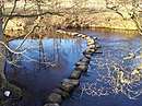 | Hathersage 53.33048°N 1.67540°W | Footpath | - | Between Offerton and Hathersage[14] | |
| 13 | Leadmill Bridge | 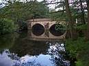 | Hathersage 53.32187°N 1.65102°W | B6001 | 18th century | II | Stone arch bridge – widened in 1928[14][15] |
| 14 | Grindleford Bridge | 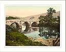 | Grindleford 53.29675°N 1.63415°W | B6251 | II & SM | Stone arch bridge[16][17] | |
| 15 | Froggatt Bridge | 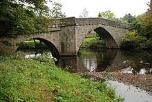 | Froggatt 53.28116°N 1.63585°W | Minor Road | 19th century | Stone arch bridge[16][18] | |
| 16 | Froggatt New Bridge | 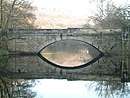 | Froggatt 53.27445°N 1.63565°W | A625 | - | Stone arch bridge[16] | |
| 17 | Calver Bridge | 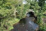 | Calver 53.26657°N 1.63146°W | Minor Road | 19th century | II* | Triple arched stone bridge[16][19] |
| 18 | Calver Bridge (A623) | .jpg) | Calver 53.26625°N 1.63206°W | A623 | 1974 | - | Modern bridge[16] |
| 19 | Baslow Bridge | .jpg) | Baslow 53.24775°N 1.62527°W | Minor road | 1608 | I & SM | Stone arch bridge with toll booth[20][21] |
| 20 | Devonshire Bridge | .jpg) | Baslow 53.24604°N 1.62337°W | A619 | 1925 | - | Bakewell Road bridge[20] |
| 21 | Chatsworth Park Bridge |  | Chatsworth 53.22800°N 1.61622°W | Minor road | 1774 | I | Designed by James Paine, providing access to Chatsworth House[20][22] |
| 22 | One Arch Bridge | 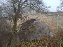 | Chatsworth 53.21241°N 1.61106°W | B6012 | 1760 | II* & SM | Also designed by James Paine, linking Edensor to Beeley[23][24] |
| 23 | Rowsley Viaduct | .jpg) | Rowsley 53.19038°N 1.61842°W | Unused | 1862 | - | Former railway viaduct[25] |
| 24 | Rowsley Bridge | 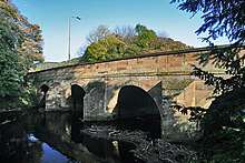 | Rowsley 53.18957°N 1.61720°W | A6 | 15th century | II* & SM | Stone arch bridge widened 1926[26][27] |
| 25 | Darley Bridge | 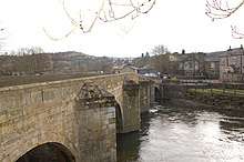 | Darley Bridge 53.15508°N 1.59697°W | B5057 | 15th century | II* & SM | Stone arch bridge[28][29] |
| 26 | Peak Rail bridge | 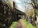 | Matlock 53.14200°N 1.56899°W | Peak Rail | - | Bridge 35[30] | |
| 27 | Derwent Way bridge | .jpg) | Matlock 53.14074°N 1.56464°W | A6 | 2007 | - | Modern A6 bridge[31] |
| 28 | Matlock Bridge | 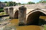 | Matlock 53.13788°N 1.55622°W | Former A6 route restored and widened 1904 | 15th century | II* & SM | Stone arch bridge[32][33] |
| 29 | Hall Leys Park footbridge | .jpg) | Matlock 53.13659°N 1.55414°W | Footpath | - | The gateway to the bridge shows flood heights in 1960 and 1965[32] | |
| 30 | Railway bridge | .jpg) | Matlock 53.13486°N 1.55643°W | Derwent Valley Line | - | Rail bridge[32] | |
| 31 | Footbridge | .jpg) | Matlock 53.13333°N 1.55684°W | Footpath | - | Dale road to Pic Tor[32] | |
| 32 | Footbridge | .jpg) | Matlock Bath 53.12600°N 1.55975°W | Footpath | - | Dale road to High Tor[32] | |
| 33 | Footbridge | .jpg) | Matlock Bath 53.12386°N 1.55791°W | Footpath | - | Dale Road to cable car[32] | |
| 34 | Matlock Bath Bridge | .jpg) | Matlock Bath 53.12189°N 1.55786°W | Access road | - | Access road to Station Yard[32] | |
| 35 | Jubilee Bridge, Matlock Bath | 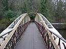 | Matlock Bath 53.12142°N 1.56154°W | Footpath | 1887 | - | Footbridge[32] |
| 36 | Derwent Gardens footbridge | .jpg) | Matlock Bath 53.11752°N 1.55990°W | Footpath | 1969 | - | Modern footbridge linking Derwent Gardens to Lovers Walk; site of earlier Matlock ferry[32] |
| 37 | Cromford Bridge | 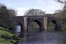 | Cromford 53.11101°N 1.55310°W | Mill Road | 15th century | II* & SM | Stone arch bridge[34][35] |
| 38 | Cromford railway bridge | .jpg) | Cromford 53.11206°N 1.54809°W | Derwent Valley Line | - | Rail bridge[34] | |
| 39 | Access bridge (High peak junction) | 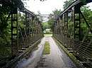 | High Peak Junction 53.10074°N 1.53171°W | Access road | - | Access to sewage works[34] | |
| 40 | Footbridge | 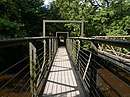 | High Peak Junction 53.10060°N 1.53127°W | Footpath | - | High Peak Junction[34] | |
| 41 | Leawood railway bridge | 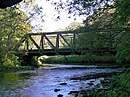 | High Peak Junction 53.09778°N 1.52882°W | Derwent Valley Line | - | Rail bridge[34] | |
| 42 | Wigwell Aqueduct |  | High Peak Junction 53.09693°N 1.52983°W | Cromford Canal | 1790s | Partially collapsed during construction; rebuilt at William Jessop's own expense[34][36] | |
| 43 | Railway bridge | High Peak Junction 53.09595°N 1.52191°W | Derwent Valley Line | - | Rail bridge[37] | ||
| 44 | Homesford footbridge | .jpg) | Whatstandwell 53.09447°N 1.51415°W | Footpath | - | Combined foot and pipe bridge[37] | |
| 45 | Railway bridge | 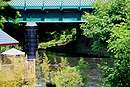 | Whatstandwell 53.08979°N 1.50692°W | Derwent Valley Line | - | Rail bridge[37] | |
| 46 | Whatstandwell Bridge | 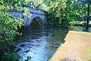 | Whatstandwell 53.08549°N 1.50704°W | A6 | 1796 | II | Stone arch bridge[37][38] |
| 47 | Oak Hurst mills bridge | Ambergate 53.06674°N 1.49193°W | Access road | - | Access bridge[39] | ||
| 48 | Halfpenny Bridge | 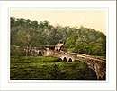 | Ambergate 53.05942°N 1.48389°W | Holly Lane | 1792 | II | Also known as Toad-Moor bridge, built as a toll bridge by Francis Hurt[39][40] |
| 49 | Derwent Viaduct | 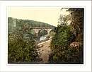 | Ambergate 53.05672°N 1.48288°W | Midland Main Line | 1840 | II* | Skewed rail bridge[39][41] |
| 50 | Railway bridge |  | Belper 53.0458°N 1.4849°W | Midland Main Line | - | Rail bridge[42] | |
| 51 | Railway bridge | .jpg) | Belper 53.0321°N 1.4830°W | Midland Main Line | - | Rail bridge[42] | |
| 52 | Belper Bridge | 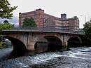 | Belper 53.02936°N 1.48725°W | Bridge Foot | 1798 | II | Tripled arched bridge[42][43] |
| 53 | Belper Meadows footbridge |  | Belper 53.02505°N 1.49173°W | Footpath | - | Access bridge[42] | |
| 54 | Belper sewage works bridge | 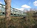 | Belper 53.01619°N 1.48501°W | Access road | - | Access bridge[42] | |
| 55 | Swainsley Railway bridge | .jpg) | Belper 53.01125°N 1.48433°W | Midland Main Line | - | Steel rail bridge[42] | |
| 56 | Milford Bridge |  | Milford 53.00231°N 1.47840°W | A6 | 1790 | II | Stone arch bridge[44] |
| 57 | Milford footbridge | _(geograph_2421660).jpg) | Milford 53.00096°N 1.47936°W | Footpath | - | Garden centre access[44][45] | |
| 58 | Moscow Farm bridge | Milford 52.99587°N 1.48139°W | Access road | - | Access bridge[44] | ||
| 59 | Duffield Church Bridge | .jpg) | Duffield 52.98290°N 1.47961°W | Makeney Road | Probable 16th century | II & SM | Stone arch bridge[44][46] |
| 60 | Burley Railway Bridge | .jpg) | Little Eaton 52.96981°N 1.47143°W | Midland Main Line | - | Rail bridge[47] | |
| 61 | Allestree Ford Bridge |  | Allestree 52.95760°N 1.46619°W | Ford Lane | - | Former ford at this point[47] | |
| 62 | Allestree A38 Bridge |  | Allestree 52.95568°N 1.46759°W | Abbey Hill | - | Dual carriageway bridge[47] | |
| 63 | Darley Abbey toll bridge | .jpg) | Darley Abbey 52.94332°N 1.47584°W | Haslams Lane | - | Toll bridge[47] | |
| 64 | Handyside Bridge | 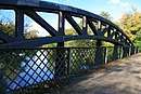 | Derby 52.93092°N 1.47747°W | Footpath | 1878 | II | Former GNR railway bridge[48][49] |
| 65 | St Marys Bridge | .jpg) | Derby 52.92716°N 1.47519°W | Minor Road | 1793 | II* & SM | Designed by Thomas Harrison, it replaced an earlier medieval bridge; adjacent is St Mary's Bridge Chapel.[48][50] |
| 66 | Causey Bridge |  | Derby 52.92667°N 1.47521°W | Saint Alkmunds Way | 1972 | - | Dual carriageway bridge[48] |
| 67 | Cathedral Green Footbridge | 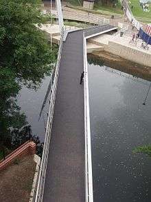 | Derby 52.92525°N 1.47522°W | Footpath | 2009 | - | Swing bridge[51] |
| 68 | Exeter Bridge | 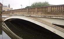 | Derby 52.92397°N 1.47382°W | Derwent Street | 1929 | - | 1920s road bridge, replaced earlier wooden bridge[48] |
| 69 | Holmes Bridge | .jpg) | Derby 52.92343°N 1.46968°W | A601 | 1972 | - | Dual carriageway bridge[48] |
| 70 | Bass Recreation Ground footbridge | 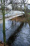 | Derby 52.92139°N 1.46592°W | Footpath | - | Modern footbridge[48] | |
| 71 | Derwent Bridge | 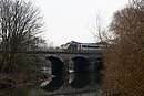 | Derby 52.91952°N 1.46376°W | Midland Main Line | 1840 | II | Skewed rail bridge, also known as Five Arches[48][52] |
| 72 | Derwent Parade bridge |  | Pride Park 52.91761°N 1.44309°W | Derwent Parade | - | Modern road bridge[48] | |
| 73 | Railway bridge Pride Park | 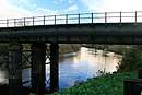 | Pride Park 52.91104°N 1.44067°W | Midland Main Line | - | Midland Main Line[48] | |
| 74 | Raynesway Bridge |  | Derby 52.90467°N 1.43049°W | A5111 | 1938 | - | A5111[53] |
| 75 | Waste Incinerator bridge | .jpg) | Derby 52.90440°N 1.42760°W | Access road | - | Access to incinerator[53] | |
| 76 | Fernhook Avenue bridge | 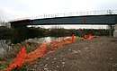 | Derby 52.90280°N 1.41177°W | Access road | 2009 | - | Access to Derby commercial park[54] |
| 77 | Access bridge | 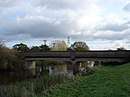 | Borrowash 52.90161°N 1.39012°W | Access road | - | Borrowash[55] | |
| 78 | Borrowash Bridge | 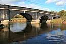 | Borrowash 52.90162°N 1.38411°W | B5010 | - | Links Borrowash to Elvaston[55] | |
| 79 | Ambaston Ford | .jpg) | Ambaston 52.89325°N 1.36010°W | Disused | - | Disused ford between Ambaston and Nooning Lane[55] | |
| 80 | Wilne footbridge | 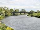 | Church Wilne 52.87868°N 1.32974°W | Footpath | 1960s | - | Replaced earlier toll bridge upstream at Wilne mills[56] |
| 81 | Derwent Mouth | 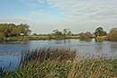 | Great Wilne 52.87291°N 1.31980°W | – | - | Confluence with the Trent[56] |
Bibliography
- Philip's (1997). Street Atlas – Derbyshire. Philip's. ISBN 0-540-06138-7.CS1 maint: ref=harv (link)
- Glover, Stephen (1829). Noble, Thomas (ed.). The History of the County of Derby. Mozley.CS1 maint: ref=harv (link)
- Cooper, Brian (1983). Transformation of a Valley: The Derbyshire Derwent (New, Scarthin 1997 Reprint ed.). London: Heinemann. ISBN 0-907758-17-7.CS1 maint: ref=harv (link)
References
- Philip's 1997, pp. 14–235.
- Cooper 1983, p. 166.
- Cooper 1983, p. 167.
- Glover 1829, p. 259.
- Philosophical Magazine, Comprehending the Various Branches of Science, the Liberal and Fine Arts, Agriculture, Manifactures, and Commerce. 1812. pp. 206–.
- Listed Buildings, English Heritage, archived from the original on 27 December 2012, retrieved 22 April 2011
- Philip's 1997, p. 14.
- Historic England. "Slippery Stones (1087992)". National Heritage List for England. Retrieved 17 January 2019.
- Philip's 1997, p. 21.
- Philip's 1997, p. 30.
- Philip's 1997, p. 39.
- Historic England. "Yorkshire Bridge (1087856)". National Heritage List for England. Retrieved 17 January 2019.
- Philip's 1997, p. 40.
- Philip's 1997, p. 52.
- Historic England. "Leadmill Bridge (1109800)". National Heritage List for England. Retrieved 17 January 2019.
- Philip's 1997, p. 72.
- Historic England. "Grindleford Bridge (1007059)". National Heritage List for England. Retrieved 17 January 2019.
- Historic England. "Froggatt Bridge (1007056)". National Heritage List for England. Retrieved 17 January 2019.
- Historic England. "Calver Bridge (1088212)". National Heritage List for England. Retrieved 17 January 2019.
- Philip's 1997, p. 91.
- Historic England. "Baslow Bridge (1088195)". National Heritage List for England. Retrieved 17 January 2019.
- Historic England. "Chatsworth Park Bridge (1049093)". National Heritage List for England. Retrieved 17 January 2019.
- Philip's 1997, p. 111.
- Historic England. "One Arch Bridge (1052356)". National Heritage List for England. Retrieved 17 January 2019.
- Philip's 1997, p. 110.
- Philip's 1997, p. 126.
- Historic England. "Rowsley Bridge (1263843)". National Heritage List for England. Retrieved 17 January 2019.
- Philip's 1997, p. 127.
- Historic England. "Darley Bridge (1248041)". National Heritage List for England. Retrieved 17 January 2019.
- Philip's 1997, p. 142.
- Roberts, Alan (15 August 2012). Matlock & Matlock Bath Through Time. Amberley Publishing Limited. pp. 84–. ISBN 978-1-4456-2948-3.
- Philip's 1997, p. 143.
- Historic England. "Matlock Bridge (1247890)". National Heritage List for England. Retrieved 17 January 2019.
- Philip's 1997, p. 155.
- Historic England. "Cromford Bridge (1263846)". National Heritage List for England. Retrieved 17 January 2019.
- Historic England. "Wigwell Aqueduct (1007040)". National Heritage List for England. Retrieved 17 January 2019.
- Philip's 1997, p. 156.
- Historic England. "Whatstandwell Bridge (1335314)". National Heritage List for England. Retrieved 17 January 2019.
- Philip's 1997, p. 167.
- Historic England. "Halfpenny Bridge (1109020)". National Heritage List for England. Retrieved 17 January 2019.
- Historic England. "Derwent Viaduct (1417625)". National Heritage List for England. Retrieved 17 January 2019.
- Philip's 1997, p. 178.
- Historic England. "Belper Bridge (1087394)". National Heritage List for England. Retrieved 17 January 2019.
- Philip's 1997, p. 191.
- Historic England. "Milford Bridge (1099189)". National Heritage List for England. Retrieved 17 January 2019.
- Historic England. "Duffield Church Bridge (1158235)". National Heritage List for England. Retrieved 17 January 2019.
- Philip's 1997, p. 205.
- Philip's 1997, p. 219.
- Historic England. "Handyside Bridge (1215438)". National Heritage List for England. Retrieved 17 January 2019.
- Historic England. "St Marys Bridge (1215897)". National Heritage List for England. Retrieved 17 January 2019.
- "New bridge for Derby". BBC. Retrieved 28 January 2019.
- Historic England. "Derwent Bridge (1417807)". National Heritage List for England. Retrieved 17 January 2019.
- Philip's 1997, p. 220.
- "New Raynesway bridge". Cass Hayward. 2009. Retrieved 27 January 2019.
- Philip's 1997, p. 234.
- Philip's 1997, p. 235.
External links
| Wikimedia Commons has media related to Bridges across the River Derwent, Derbyshire. |