List of African-American historic places in West Virginia
This is intended to be a complete list of the African American historic places in West Virginia. The locations and districts for which the latitude and longitude coordinates are included below, may be seen in a Google map.[1]
| Color | Denotes |
|---|---|
| NRHP listing | National Register of Historic Places listing |
| NRHP HD | National Register Historic District |
| Not listed on the NRHP | Not listed on the National Register |
| Berkeley - Cabell - Fayette - Hampshire - Harrison - Jefferson - Kanawha - Lewis - McDowell - Mercer - Monongalia - Wood |
Berkeley County
| [2] | Name on the Register | Image | Date listed[3] | Location | City or town | Description |
|---|---|---|---|---|---|---|
| 1 | Mt. Pleasant School | 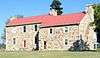 Mt. Pleasant School |
September 18, 2008 (#08000928) |
Abiding Way 39°21′49″N 78°07′28″W |
Gerrardstown |
Cabell County
| [2] | Name on the Register | Image | Date listed[3] | Location | City or town | Description |
|---|---|---|---|---|---|---|
| 1 | Barnett Hospital and Nursing School | 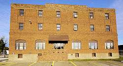 Barnett Hospital and Nursing School |
December 30, 2009 (#09001190) |
1201 7th Ave. 38°25′03″N 82°26′15″W |
Huntington | |
| 2 | Douglass Junior and Senior High School | 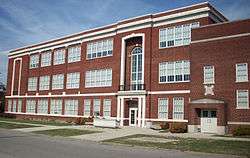 Douglass Junior and Senior High School |
December 5, 1985 (#85003091) |
10th Ave. and Bruce St. 38°24′52″N 82°25′53″W |
Huntington | |
| 3 | West Virginia Colored Children's Home | 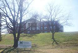 West Virginia Colored Children's Home |
November 13, 1997 (#97001413) |
3353 U.S. Route 60 38°24′34″N 82°22′25″W |
Huntington | Demolished on May 5, 2011 to make room for a new middle school.[4][5] |
Fayette County
| [2] | Name on the Register | Image | Date listed[3] | Location | City or town | Description |
|---|---|---|---|---|---|---|
| 1 | Camp Washington-Carver Complex | 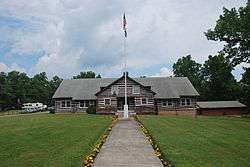 Camp Washington-Carver Complex |
June 20, 1980 (#80004017) |
County Route 11/3 38°00′36″N 80°58′14″W |
Clifftop |
Hampshire County
| [2] | Name on the Register | Image | Date listed[3] | Location | City or town | Description |
|---|---|---|---|---|---|---|
| 1 | Mount Pisgah Benevolence Cemetery | Not listed (#unlisted) |
Along U.S. Route 50 39°20′30″N 78°46′04″W |
Romney | ||
| 2 | Washington Place | 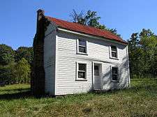 Washington Place |
Not listed (#unlisted) |
Along West Virginia Route 28 39°21′14″N 78°45′09″W |
Romney |
Harrison County
| [2] | Name on the Register | Image | Date listed[3] | Location | City or town | Description |
|---|---|---|---|---|---|---|
| 1 | Kelly Miller High School | Not listed (#unlisted) |
E. B. Saunders Way 39°16′36″N 80°20′09″W |
Clarksburg |
Jefferson County
| [2] | Name on the Register | Image | Date listed[3] | Location | City or town | Description |
|---|---|---|---|---|---|---|
| 1 | Halltown Colored Free School | 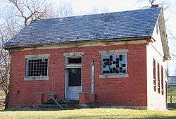 Halltown Colored Free School |
August 25, 2004 (#04000912) |
Halltown Rd., 0.5 mi (0.80 km) northeast of U.S. Route 340 39°18′44″N 77°48′06″W |
Halltown | |
| 2 | Halltown Union Colored Sunday School | 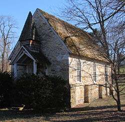 Halltown Union Colored Sunday School |
January 12, 1984 (#84003591) |
Off U.S. Route 340 39°18′34″N 77°48′11″W |
Halltown | |
| 3 | Storer College |  Storer College |
October 15, 1966 (#66000041) |
Contributing property to Harpers Ferry National Historical Park NRHP listing 39°19′26″N 77°44′07″W |
Harpers Ferry |
Kanawha County
| [2] | Name on the Register | Image | Date listed[3] | Location | City or town | Description |
|---|---|---|---|---|---|---|
| 1 | African Zion Baptist Church | 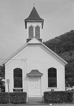 African Zion Baptist Church |
December 27, 1974 (#74002010) |
4104 Malden Dr. 38°17′58″N 81°33′26″W |
Malden | |
| 2 | Booker T. Washington High School | December 3, 1999 (#99001399) |
Wyatt St. off U.S. Route 60 38°12′04″N 81°22′17″W |
London | ||
| 3 | Booker T. Washington State Park | 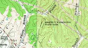 Booker T. Washington State Park |
Not listed (#unlisted) |
Northern terminus of Pinewood Drive 38°22′55″N 81°44′53″W |
Institute | |
| 4 | Canty House | 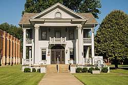 Canty House |
September 23, 1988 (#88001587) |
WV 25 38°22′57″N 81°45′48″W |
Institute | |
| 5 | East Hall | 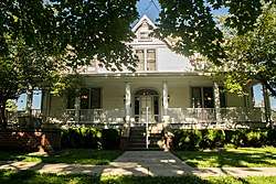 East Hall |
September 26, 1988 (#88001585) |
West Quadrangle, West Virginia State University 38°22′44″N 81°46′07″W |
Institute | |
| 6 | Garnet High School | 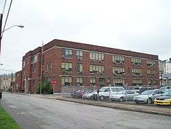 Garnet High School |
July 24, 1990 (#90001068) |
422 Dickinson St. 38°21′04″N 81°37′48″W |
Charleston | |
| 7 | Elizabeth Harden Gilmore House | 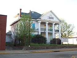 Elizabeth Harden Gilmore House |
September 17, 1988 (#88001462) |
514 Broad St. (now Leon Sullivan Way) 38°21′03″N 81°37′39″W |
Charleston | |
| 8 | Mattie V. Lee Home | 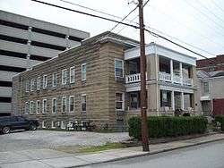 Mattie V. Lee Home |
June 16, 1992 (#92000303) |
810 Donnally St. 38°21′06″N 81°37′51″W |
Charleston | |
| 9 | Simpson Memorial Methodist Episcopal Church |  Simpson Memorial Methodist Episcopal Church |
August 5, 1991 (#91001011) |
607 Shrewsbury St. 38°21′06″N 81°37′44″W |
Charleston | |
| 10 | Samuel Starks House |  Samuel Starks House |
February 1, 1988 (#87002526) |
413 Shrewsbury St. 38°21′02″N 81°37′50″W |
Charleston |
Lewis County
| [2] | Name on the Register | Image | Date listed[3] | Location | City or town | Description |
|---|---|---|---|---|---|---|
| 1 | Weston Colored School | 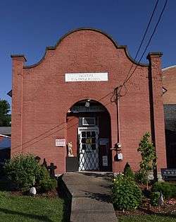 Weston Colored School |
April 9, 1993 (#93000224) |
345 Center St. 39°02′23″N 80°27′53″W |
Weston |
McDowell County
| [2] | Name on the Register | Image | Date listed[3] | Location | City or town | Description |
|---|---|---|---|---|---|---|
| 1 | World War Memorial | 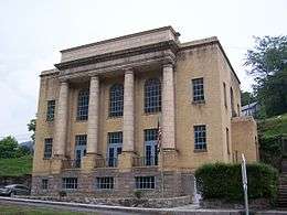 World War Memorial |
April 9, 1993 (#93000227) |
U.S. Route 52 37°25′31″N 81°30′24″W |
Kimball |
Mercer County
| [2] | Name on the Register | Image | Date listed[3] | Location | City or town | Description |
|---|---|---|---|---|---|---|
| 1 | Hancock House | January 17, 1990 (#89001783) |
300 Sussex St. 37°16′33″N 81°13′13″W |
Bluefield |
Monongalia County
| [2] | Name on the Register | Image | Date listed[3] | Location | City or town | Description |
|---|---|---|---|---|---|---|
| 1 | Second Ward Negro Elementary School |  Second Ward Negro Elementary School |
July 28, 1992 (#92000896) |
Junction of White and Posten Aves. 39°37′17″N 79°56′57″W |
Morgantown |
Wood County
| [2] | Name on the Register | Image | Date listed[3] | Location | City or town | Description |
|---|---|---|---|---|---|---|
| 1 | Bethel AME Church | 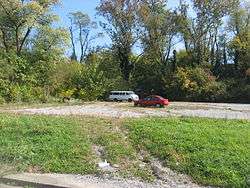 Bethel AME Church |
October 8, 1998 (#82001767) |
820 Clay St. 39°15′58″N 81°33′18″W |
Parkersburg | Demolished |
| 2 | Henry Logan Memorial AME Church | 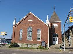 Henry Logan Memorial AME Church |
December 16, 1982 (#82001778) |
Ann and 6th Sts. 39°16′05″N 81°33′41″W |
Parkersburg |
See also
References
- The latitude and longitude information provided in this table was derived originally from the National Register Information System, which has been found to be fairly accurate for about 99% of listings. Some locations in this table may have been corrected to current GPS standards.
- Numbers represent an ordering by significant words. Various colorings, defined here, differentiate National Historic Landmarks and historic districts from other NRHP buildings, structures, sites or objects.
- The eight-digit number below each date is the number assigned to each location in the National Register Information System database, which can be viewed by clicking the number.
- http://www.herald-dispatch.com/news/briefs/x1411939090/Cabell-school-officials-ready-to-mitigate-loss-of-old-orphanage
- Herald-Dispatch.com, Huntongton, WV, May 6, 2011
This article is issued from Wikipedia. The text is licensed under Creative Commons - Attribution - Sharealike. Additional terms may apply for the media files.