Lincoln Cliff
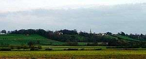
The Lincoln Cliff or Lincoln Edge (also known as the Trent Cliff.[1]) is the portion of a major escarpment that runs north–south through Lindsey and Kesteven in central Lincolnshire and is a prominent landscape feature in a generally flat portion of the county.[2]
Description
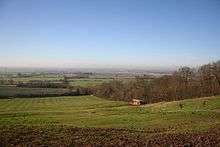
The scarp is formed by resistant Middle Jurassic rocks, principally the Lincolnshire Limestone series,[3] and is remarkable for its length and straightness. It runs for over 50 miles from the Leicestershire border near Grantham to the Humber Estuary, and is broken only twice by river gaps at Ancaster and Lincoln, through which the rivers Slea and Witham respectively flow.[2][4]
To the west of the Cliff north of Lincoln lies the River Trent, with the valley of the Witham to the west south of Lincoln. The top of the Cliff is followed by two historically significant roads. Closely following the escarpment is an ancient trackway, loosely known as the Jurassic Way,[5] which in large parts now consists of the A607 south of Lincoln and the B1398 to the north. The second road is the Roman Ermine Street that runs parallel a few miles to the east of the Edge.
North of Lincoln, the name Lincoln Cliff, or simply the Cliff, is locally used to refer to the entire ridge of Jurassic Limestone, not just its steep western scarp. This can be seen in placenames such as Welton Cliff, Saxby Cliff and Caenby Cliff, reflecting parish-based divisions of the ridge. This use of the name is not found south of Lincoln, where the term Cliff refers only to the scarp itself, as distinct from the limestone plateau (which is here called the Lincoln Heath). To minimise confusion, some people prefer the name Lincoln Edge or Lincolnshire Edge for the scarp that runs from Grantham to the Humber, reserving the name Lincoln Cliff for the section of limestone ridge north of Lincoln.[4]
Route
From north to south the 'cliff villages', many of them spring-line villages, are as follows:
- Winteringham, on the bank of the Humber
- Winterton
- Roxby
- Burton upon Stather
- Scunthorpe
- Kirton in Lindsey
- Grayingham
- Blyborough
- Willoughton
- Hemswell
- Harpswell
- Glentworth
- Fillingham
- Ingham
- Cammeringham
- Brattleby
- Aisthorpe
- Scampton
- North Carlton
- South Carlton
- Burton by Lincoln
- Lincoln – break in the Edge (River Witham)
- Canwick
- Bracebridge Heath
- Waddington
- Harmston
- Coleby
- Boothby Graffoe
- Navenby
- Wellingore
- Welbourn
- Leadenham
- Fulbeck
- Caythorpe
- Normanton
- Carlton Scroop
- Ancaster – break in the Edge (River Slea)
- Honington
- Barkston
- Syston
- Belton
- Londonthorpe
- Manthorpe
- Grantham
References
- Symes, David, ed. (1987), Humberside in the Eighties, pp. 333, 340, ISBN 0-85958-119-5
- "Northern Lincolnshire Edge with Coversands and Southern Lincolnshire Edge" (PDF). Natural England. Retrieved 8 April 2013.
- "Lincolnshire". Natural England. Geological highlights. Archived from the original on 18 February 2013. Retrieved 20 March 2013.
- David Tyldesley and Associates (September 2007). "North Kesteven Landscape Character Assessment" (PDF). North Kesteven District Council. Retrieved 8 April 2013.
- "The Jurassic Way". City of Lincoln Council/English Heritage. Retrieved 20 March 2013.; Not to be confused with the modern footpath of the same name designated by Northampton County Council