Leopold Quarter
The Leopold Quarter (French: Quartier Léopold, Dutch: ![]()
The Leopold Quarter traditionally encompassed the area immediately south of the inner ring road, between the Namur Gate and Louvain Gate. Today it lies roughly between the ring road, Leopold Park, Rue Joseph II/Jozef II Straat, and Rue du Trone/Troonstraat.[2] The district was created in 1837, soon after Belgian independence, as a prestigious residential area for the elite of the new Belgian capital, and was named after King Leopold I.[3] It remained the most prestigious residential address in the capital until the early 20th century when many of its former residents began to relocate to Brussels' newly developing suburbs.[4] Starting at that time, but accelerating rapidly only after the 1950s, it increasingly became a business/institutional area and is today dominated by the EU's facilities.
The quarter contains the European Parliament (with its building known as the Espace Léopold) and other EU offices.[5] It is also a major financial district of Brussels. The Brussels-Luxembourg Station was formerly known as the Leopold Quarter Station before undergoing major rebuilding.[6]
History
Construction
The area south-east of the second walls of Brussels was largely rural until the 19th century. In the last years of Austrian rule, plans were mooted to build a new residential district outside of the crowded city walls, in the area which became the Leopold Quarter. When the walls were torn down in the wake of the Napoleonic Wars, a plan was adopted to transform the area formerly occupied by the walls into a boulevard, which is today the inner ring road of Brussels. In the wake of the Belgian Revolution in 1830, the new members of the Belgian upper class hoped to create a new prestigious residential area in the capital. An official plan for the quarter was drawn up by Tilman-Francois Suys in 1838. The area was designed to emanate from Brussels' Park located behind the palace. The area was laid out on a grid in a traditional classical pattern. The Leopold Quarter was quickly developed and already had 500 residents by 1847. By 1853, the population had reached 3,212, most property owners or landed gentry with domestic staff.[7] Other typical residents included civil servants, military officers, members of liberal professions, embassy staff, and representatives of foreign companies.
A railway station called Leopold Quarter Station (French: Gare du Quartier Léopold) was built, along with a large square at the end of Rue de Luxembourg/Luxemburgstraat, between 1854–1855. The station is today known as Brussels-Luxembourg Station, while the square is still known as Luxembourg Square. They had not been included in Suys' original plans, as the railroad was a new development in the 1830s in Belgium. Designed by Gustave Saintenoy, the station and the railway came to be a defining feature of the area's geography. In those days, the outer edge of the area was defined by the Maalbeek river valley, but in the 1850s plans were drawn up to build a bridge across it to connect Rue de la Loi/Wetstraat to the new military parade ground on the Linthout Plateau (today Parc du Cinquantenaire/Jubelpark).[8]
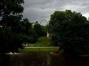
The Eggevoorde Estate had dominated the Maelbeek valley since the Middle Ages, but portions had been sold off in the following centuries. In 1851, a portion was sold off in exchange for shares in the Zoological and Horticultural Society, and the area became what is today Leopold Park. The park was intended to be a home for scientific and leisure activities. Horticultural gardens and a zoo were created along with a community hall, a reading room, and a café-restaurant. However, the zoo was poorly managed and the management company went bankrupt in 1876. The horticultural gardens on the other hand were quite successfully managed by Jean Linden, and they became a commercial and scientific success story until 1898, when they were sold. The City of Brussels bought the old Zoological gardens and they were converted into a public recreational park containing a variety of diversions, including the Museum of Natural Sciences. In 1884 Ernest Solvay and Paul Héger, professors at the Université Libre de Bruxelles began a project to create an expanded university campus in the park. Several of the university's new institutes were created in the park, and stand to this day, including the original site of the Solvay Institute of Sociology.
20th century
The population of the area peaked around 1900.[9] By 1930 the population had declined by 30%. Railway connections, and then the rise in car ownership, allowed the wealthy residents to live further from the city in more open suburbs. The increasingly old fashioned mansions in the area, which were generally designed for use by families with the help of domestic servants, became increasingly difficult to maintain. Property developers started building apartments in the area in the 1920s and increasingly in the 1930s, initiating a gradual change in its architectural character.[10] Slowly at first, companies began purchasing unused mansions and adapting them to their use. Then after the Second World War, several insurance companies and colonial organisations began a trend toward demolishing the 19th century mansions and townhouses, and replacing them with new modern office blocks.[11] With changes to the road infrastructure of the inner ring road for the 1958 World's Fair the area became even more attractive to companies, being located between Brussels' administrative centre and the residential suburbs further out. With the growing economy, and then the arrival of the first European Institutions in the late 1950s, the area became a major target for property developers when building office space for institutional and corporate use. Brussels had no development plan, and did not enforce existing legal restrictions, so most remaining residents left during this time as it had become completely transformed from a formerly quiet residential area into a congested centre of transport and business.[12]
Recent redevelopment
In 1987, the old Leopold brewery was torn down in anticipation of the construction of what would become the Espace Léopold, which was unofficially intended to house the European Parliament. Political and legal wrangling had continually delayed a final conclusion regarding the unofficial seat for the parliament. However, as Brussels hoped to keep all of the official institutions in Europe, provision was made for the construction of a suitable facility (see Brussels and the European Union). The construction of the massive facility changed the face of the district again, putting the above ground railway tracks of the Leopold Quarter train station below ground and renaming it as the Brussels-Luxembourg Station.

See also
- Brussels and the European Union
- Leopold Park
- Rue Belliard
- Luxembourg Square
- Jean Rey Square
Notes
- The West European City, Google Books
- Demey, 30
- The Globalized City, Google Books
- Demey, Thierry (2007). Brussels, capital of Europe. Brussels: Badeaux.
- Brussels and Europe, Google Books
- Travel Brussels, Belgium, Google Books
- Demey, 43.
- Demey, 49.
- Demey, 72.
- Demey, 428.
- Demey, 74.
- Demey, 75.
Bibliography
- Dickinson, Robert Eric. "Brussels." In The West European City; A Geographical Interpretation. Vol 12 ed. London: Routledge & Paul, 1951. 154.
- Groof, Roel, and Els Witte. "The Legal Status of Brussels as a European 'Capital'." In Brussels and Europe: [the position of Brussels in the World City Network ; inter actions between the European institutional presence and the Brussels-capial region] ; acta of the International Colloquium on Brussels and Europe, held in the Albert Borschet. Brussel: Academic and Scientific Publ., 2008. 133.
- Moulaert, Frank, Arantxa Rodríguez, and Erik Swyngedouw. The globalised city: economic restructuring and social polarisation in European cities. 1. publ. ed. Oxford [u.a.: Oxford University Press, 2003. 129.