Le Bois-d'Oingt
Le Bois-d'Oingt is a former commune located in the Rhône in the Auvergne-Rhône-Alpes region, in eastern France. On 1 January 2017, Le Bois-d'Oingt, Oingt and Saint-Laurent-d'Oingt merged becoming one commune of Val d'Oingt.[2]
Le Bois-d'Oingt | |
|---|---|
Part of Val d'Oingt | |
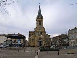 Place de la libération in Le Bois-d'Oingt | |
.svg.png) Coat of arms | |
Location of Le Bois-d'Oingt 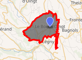
| |
 Le Bois-d'Oingt  Le Bois-d'Oingt | |
| Coordinates: 45°55′16″N 4°35′10″E | |
| Country | France |
| Region | Auvergne-Rhône-Alpes |
| Department | Rhône |
| Arrondissement | Villefranche-sur-Saône |
| Canton | Le Bois-d'Oingt |
| Commune | Val d'Oingt |
| Area 1 | 5.13 km2 (1.98 sq mi) |
| Population (2017-01-01)[1] | 2,503 |
| • Density | 490/km2 (1,300/sq mi) |
| Demonym(s) | Buisantins, Buisantines |
| Time zone | UTC+01:00 (CET) |
| • Summer (DST) | UTC+02:00 (CEST) |
| Postal code | 69620 |
| Elevation | 250–466 m (820–1,529 ft) (avg. 300 m or 980 ft) |
| 1 French Land Register data, which excludes lakes, ponds, glaciers > 1 km2 (0.386 sq mi or 247 acres) and river estuaries. | |
Geography
Le Bois d'Oingt's acreage is of 1.976 square mile (512 hectares), and it lies at 350 meters altitude.
The inhabitants of Bois d’Oingt are called the “buisantins”.
See also
References
- "Populations légales 2017". INSEE. Retrieved 6 January 2020.
- (in French) Arrêté du 22 septembre 2016 portant création de la commune nouvelle de Val d'Oingt, Journal officiel.
| Wikimedia Commons has media related to Le Bois-d'Oingt. |
| Authority control |
|
|---|
This article is issued from Wikipedia. The text is licensed under Creative Commons - Attribution - Sharealike. Additional terms may apply for the media files.