Lares barrio-pueblo
Lares barrio-pueblo is a barrio and the administrative center (seat) of Lares, a municipality of Puerto Rico. Its population in 2010 was 2,690.[1][3][4][5]
Lares barrio-pueblo Barrio Pueblo Lares Lares Barrio Pueblo | |
|---|---|
Municipality Seat[1] | |
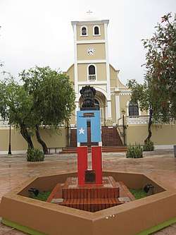 Church and monument, Plaza de la Revolución | |
 Lares barrio-pueblo | |
| Coordinates: 18°17′46″N 66°52′53″W[2] | |
| Commonwealth | |
| Municipality | |
| Population (2010) | |
| • Total | 2,690 |
| Source: 2010 Census | |
| Time zone | UTC−4 (AST) |
As was customary in Spain, in Puerto Rico, the municipality has a barrio called pueblo which contains a central plaza, the municipal buildings (city hall), and a Catholic church. Fiestas patronales (patron saint festivals) are held in the central plaza every year.[6][7]
History
The United States took control of Puerto Rico from Spain in the aftermath of the Spanish-American War under the terms of the Treaty of Paris of 1898. In 1899, the United States conducted its first census of Puerto Rico, finding that the population of Lares Pueblo was 1,450.[8]
The central plaza history
Plaza de la revolución is the name of the central plaza located in Lares Barrio Pueblo.[9] The central plaza, or square, is a place for official and unofficial recreational events and a place where people can gather and socialize from dusk to dawn. The Laws of the Indies, Spanish law, which regulated life in Puerto Rico in the early 19th century, stated the plaza's purpose was for "the parties" (celebrations, festivities) (Spanish: a propósito para las fiestas), and that the square should be proportionally large enough for the number of neighbors (Spanish: grandeza proporcionada al número de vecinos). These Spanish regulations also stated that the streets nearby should be comfortable portals for passersby, protecting them from the elements: sun and rain.[6]
Sectors

Lares barrio-pueblo is further subdivided into smaller local populated place areas/units called sectores (sectors in English). The types of sectores may vary, from normally sector to urbanización to reparto to barriada to residencial, among others.[10][11][12][13][14]
Aurelio Bernal, Barriada Arizona, Barriada Bajadero, Barriada San Felipe, Barriada Viera, Calle Aldarondo, Calle Echegaray, Calle El Peligro, Calle Emilio Castro Rodríguez, Calle Ermita, Calle Felipe Arana, Calle Hospital, Calle La Gallera, Calle Molino, Calle Muñoz Rivera, Calle Palmer, Calle Rafael Castro, Calle Raúl Gándara, Calle San José, Sector Barranco, Calle San Pablo, Calle Sócrates González, Calle Vilella, Calle Villa Independencia, Calle Virgilio Acevedo, Camino González, Camino Henrry Arana, Carretera Acueducto, Cerro Márquez, Condominio Lares Gardens, Dr. Pedro Albizu Campos, Edificio Parques Platinos, Edificio Terrazas El Peligro, El Leñero, Ensanche González, Ensanche Sur, Extensión Altamira, Población, Ramal 111 Interior, Ramal 111 Int. (Emisora), Residencial Dr. Francisco Seín, Sector Desvío, Sector Guajataca, Sector Jardín De la Pasión, Sector Jayal, Sector Jobos, Sector La Monserrate, Sector La Sierra, Sector Los Torres, Sector Mercedes Estades, Sector Monte Bello, Sector Punta Brava, Tramo Carretera 124, Urbanización Altamira, Urbanización Buena Vista Calle Lecaroz, Urbanización Buena Vista, Urbanización Jardines de Lares, Urbanización Monte Bello, Urbanización Villa Borinquen, and Urbanización Villa Seral.[15]
Gallery
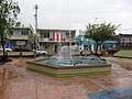 Fountain in Plaza de la Revolución
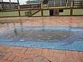 Map mosaic at Plaza de la Revolución
 Catholic Church in Lares
 City Hall, 2019
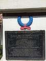 Plaque in Plaza de la Revolución
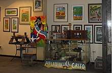 Ice cream shop Heladería El Grito owned by Jose Rodríguez Ruiz, mayor of Lares in 2020
See also
References
- Puerto Rico:2010:population and housing unit counts.pdf (PDF). U.S. Dept. of Commerce, Economics and Statistics Administration, U.S. Census Bureau. 2010.
- U.S. Geological Survey Geographic Names Information System: Lares barrio-pueblo
- Picó, Rafael; Buitrago de Santiago, Zayda; Berrios, Hector H. Nueva geografía de Puerto Rico: física, económica, y social, por Rafael Picó. Con la colaboración de Zayda Buitrago de Santiago y Héctor H. Berrios. San Juan Editorial Universitaria, Universidad de Puerto Rico,1969.
- Gwillim Law (20 May 2015). Administrative Subdivisions of Countries: A Comprehensive World Reference, 1900 through 1998. McFarland. p. 300. ISBN 978-1-4766-0447-3. Retrieved 25 December 2018.
- "US Census Barrio-Pueblo definition". factfinder.com. US Census. Archived from the original on 13 May 2017. Retrieved 5 January 2019.
- Santullano, Luis A. (10 March 2019). Mirada al Caribe. 54. Colegio de Mexico. pp. 75–78. doi:10.2307/j.ctvbcd2vs.12. JSTOR j.ctvbcd2vs.12.
- Pariser, Harry S. (2003). Explore Puerto Rico, Fifth Edition. San Francisco: Manatee Press. pp. 52–55. Retrieved 10 February 2019.
- Joseph Prentiss Sanger; Henry Gannett; Walter Francis Willcox (1900). Informe sobre el censo de Puerto Rico, 1899, United States. War Dept. Porto Rico Census Office (in Spanish). Imprenta del gobierno. p. 160.
- "Lares, ¿grito, insurrección o revolución? [Lares, cry, insurrection or revolution?]". El Nuevo Dia (in Spanish). 23 September 2018. Retrieved 20 June 2020.
- Mari Mut, José A. (28 August 2013). "Los pueblos de Puerto Rico y las iglesias de sus plazas" (in Spanish). Retrieved 19 June 2020 – via archive.org.
- "Agencia: Oficina del Coordinador General para el Financiamiento Socioeconómico y la Autogestión (Proposed 2016 Budget)". Puerto Rico Budgets (in Spanish). Retrieved 28 June 2019.
- Rivera Quintero, Marcia (2014), El vuelo de la esperanza : Proyecto de las Comunidades Especiales Puerto Rico, 1997-2004 (Primera edición ed.), San Juan, Puerto Rico Fundación Sila M. Calderón, ISBN 978-0-9820806-1-0
- "Leyes del 2001". Lex Juris Puerto Rico (in Spanish). Retrieved 24 June 2019.
- "Comunidades Especiales de Puerto Rico" (in Spanish). 8 August 2011. Retrieved 24 June 2019.
- "PRECINTO ELECTORAL LARES 053" (PDF). Comisión Estatal de Elecciones (in Spanish). PR Government. 14 June 2019. Retrieved 19 June 2019.