Laonong River
The Laonong River, also spelled Laonung River (Chinese: 荖濃溪; pinyin: Lǎo nóng xī; Wade–Giles: Lao3-nung2 Hsi1),[2] is a tributary of the Gaoping River in Taiwan;[3][4] it is the main course of the river system above the Gaoping River.[4] It flows through Kaohsiung City for 136 km.[1]
| Laonong River | |
|---|---|
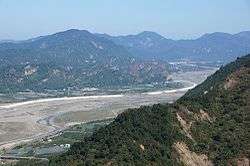 | |
 Map showing the mouth of Laonong River at its confluence with the Ailiao River | |
| Location | |
| Country | Taiwan |
| Physical characteristics | |
| Source | |
| ⁃ location | Central Mountain Range: Yushan |
| ⁃ coordinates | 23.4700°N 120.95717°E |
| ⁃ elevation | 3,952 m (12,966 ft) |
| Mouth | |
⁃ location | Liouguei |
⁃ coordinates | 22.7969°N 120.5117°E |
| Length | 136 km (85 mi) |
| Basin size | 1,372 km2 (530 sq mi) |
| Discharge | |
| ⁃ location | Liouguei Bridge[1] |
| ⁃ average | 52 m3/s (1,800 cu ft/s) |
| ⁃ minimum | 0.01 m3/s (0.35 cu ft/s) |
| ⁃ maximum | 5,130 m3/s (181,000 cu ft/s) |
| Basin features | |
| River system | Gaoping River |
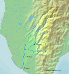
Map of the Gaoping River watershed showing Laonong
See also
- List of rivers in Taiwan
References
- "98年高屏溪流域管理工作執行年報" (PDF) (in Chinese). Gaoping River Basin Management Committee. October 2010. Retrieved 12 June 2016.
- "GeoNames Search". Geographic Names Database. National Geospatial-Intelligence Agency, USA. Retrieved 12 June 2016.
- "Gaoping River" (in Chinese). Water Resources Agency, Ministry of Economic Affairs. Archived from the original on 4 March 2016. Retrieved 12 June 2016.
- Liu, James T.; Hsu, Ray T.; Hung, Jia-Jang; Chang, Yuan-Pin; Wang, Yu-Huai; Rendle-Bühring, Rebecca H.; Lee, Chon-Lin; Huh, Chih-An; Yang, Rick J. (2016). "From the highest to the deepest: The Gaoping River–Gaoping Submarine Canyon dispersal system". Earth-Science Reviews. 153: 274–300. doi:10.1016/j.earscirev.2015.10.012.
This article is issued from Wikipedia. The text is licensed under Creative Commons - Attribution - Sharealike. Additional terms may apply for the media files.