Lakeview Gusher
Lakeview Gusher Number One was an eruption of hydrocarbons from a pressurized oil well in the Midway-Sunset Oil Field in Kern County, California, in 1910. It created the largest accidental oil spill in history, lasting 18 months and releasing 9 million barrels (1.4×10⁶ m3) of crude oil.[1]
| Lakeview Gusher Number One | |
|---|---|
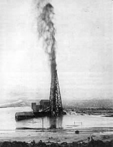 The Lakeview gusher with a lake of crude oil surrounding the derrick, mid-1910 | |
| |
| Location | Kern County, California |
| Coordinates | 35.091424°N 119.401377°W |
| Date | 14 March 1910 – September 1911 |
| Cause | |
| Cause | Wellhead blowout |
| Operator | Lakeview Oil Company |
| Spill characteristics | |
| Volume | 9 million barrels (1.4×10⁶ m3) |
| Reference no. | 485 |

Midway-Sunset was one of the largest oil reserves in the United States. When drilling commenced, the Lakeview Oil Company expected natural gas and a small amount of oil. Instead, there was a large blowout which overloaded storage tanks.[2]
The geyser released more than 1.2 million short tons (1,100,000 t) of crude oil, far more than any other single leak on land or water. Its site is located about a half-mile (800 m) east of the Taft–Maricopa Highway, California Route 33, marked by a Caltrans guide sign and a bronze plaque designated as California Historical Landmark number 485.[3]
Background
The Lakeview Oil Company started drilling at its Number One well on 1 January 1909. Initially only natural gas was found. As work continued the company partnered with the Union Oil Company, which wanted to build storage tanks there.[4]
Early twentieth-century drilling technology lacked such modern safety features as blowout preventers. When drilling reached a well depth of 2,440 ft (740 m) on 15 March 1910,[5] pressurized oil blew through the well casing above the bit. An estimated 9 million barrels (1.4×10⁶ m3) escaped before the gusher was brought under control in September 1911.[6]
The initial daily flow was 18,800 barrels (2,990 m3), creating a river of crude that crews rushed to contain with improvised sand bag dams and dikes. Peak flow reached 90,000 barrels (14,000 m3) per day, diverted via a pipeline to storage tanks 2.5 miles (4.0 km) away, where an 8-inch (200 mm) line led to Port Avila on the coast.[2] In spite of these efforts, less than half of the 9.4 million barrels released during the gusher's 544 days were saved. The rest evaporated or seeped into the ground.[2]
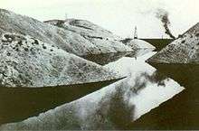 River of crude contained by dikes
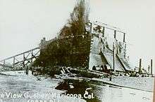 A timber containment box was pulled over the gusher with heavy cables, soon destroyed by the oil's pressure
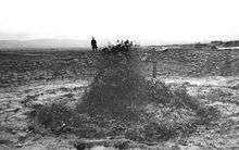 Gusher after the well had partially subsided, the derrick removed, and the well surrounded by a sandbag berm
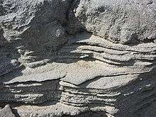 Stratified, congealed crude oil 100 ft (30 m) from the gusher site. The March 2008 image shows an area about 10 in (250 mm) across.
See also
- List of oil spills (in reverse chronological order)
- Largest oil spills in history
References
- Harvey, Steve (13 June 2010). "California's legendary oil spill". Los Angeles Times. Retrieved 14 July 2010.
- "The Lakeview Gusher". San Joaquin Geological Society. 23 September 2002. Archived from the original on 19 October 2006. Retrieved 11 June 2010.
- "Lakeview Gusher". Office of Historic Preservation, California State Parks. Retrieved 2012-10-07.
- Bailey, Richard C. (1967). Kern County Place Names. Bakersfield: Merchant's Printing and Lithography Co. OCLC 158106.
- Rintoul, William (1976). Spudding In: Recollections of Pioneer Days in the California Oil Fields. San Francisco: California Historical Society. pp. 106–113. ISBN 978-0-910312-37-0.
- Rintoul, William; Hodgson, Susan F. (1990). Drilling through time: 75 years with California's Division of Oil and Gas. Sacramento: California Department of Conservation, Division of Oil and Gas. pp. 13–15. ISBN 978-0-9627124-0-1.
External links
| Wikimedia Commons has media related to Lakeview Gusher. |