Lakes of Killarney
The Lakes of Killarney are a scenic attraction located in Killarney National Park near Killarney, County Kerry, in Ireland. They consist of three lakes - Lough Leane, Muckross Lake (also called Middle Lake) and Upper Lake.[1]
| Lakes of Killarney | |
|---|---|
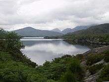
 The Lakes of Killarney from nearby Torc Mountain | |
| Location | Killarney, County Kerry |
| Coordinates | 52°2′30″N 9°33′0″W |
| Type | Lake |
| Basin countries | Ireland |
| Average depth | 13.4 m (44 ft) |
| Max. depth | 75 m (246 ft) |
| Surface elevation | 20 m (66 ft) |
| Islands | Innisfallen Island, |
Surroundings
The lakes sit in a low valley some 20 m (66 ft) above sea level.[1] They are surrounded by the rugged slopes of MacGillycuddy's Reeks. Notable mountains in the range include Carrauntoohil, which, at 1,038 metres (3,406 ft) is Ireland's highest mountain, Purple Mountain, at 832 metres (2,730 ft), Mangerton Mountain, at 843 metres (2,766 ft), and Torc Mountain, at 535 metres (1,755 ft).
The N71 road from Killarney to Kenmare passes a viewpoint called Ladies View which offers a view of the lakes and valleys. On the occasion of Queen Victoria's visit in 1861, the point was apparently chosen by the queen's ladies-in-waiting as the finest in the land; hence the name.[2]
Lough Leane
.jpg)
Lough Leane (from Irish Loch Léin, meaning 'lake of learning')[3] is the largest and northernmost of the three lakes, approximately 19 square kilometres (4,700 acres) in size.[4] It is also the largest body of fresh water in the region.[5] The River Laune drains Lough Leane to the north-west towards Killorglin and into Dingle Bay.
Leane is dotted with small forested islands, including Innisfallen Island, which holds the remains of the ruined Innisfallen Abbey.[1] On the eastern edge of the lake, Ross Island, more properly a peninsula, was the site of some of the earliest Copper Age metalwork in prehistoric Ireland.[6] Ross Castle, a 15th-century keep, sits on the eastern shore of the lake, north of the Ross Island peninsula.
Muckross Lake

Also known as Middle Lake or Torc Lake, Muckross is just south of Lough Leane.[7] The two are separated by a small peninsula, crossed by a stone arched bridge called Brickeen Bridge.[1] It is Ireland's deepest lake, reaching to 75 metres (246 ft) in parts.[8] A paved hiking trail of approximately 10 km (6.2 mi) circles the lake.[2]
Upper Lake
The Upper Lake is the smallest of the three lakes, and the southernmost. It is separated from the others by a winding channel some 4 km (2.5 mi) long.[1]
Gallery
 Ross Castle visible across Lough Leane
 View near Ross Castle
 Brickeen Bridge, where Lough Leane and Muckross Lake meet
 The lakes as viewed from Ladies View
 Another view from the Ladies View point
 Hand-drawn map of the Lakes by French artist Alphonse Dousseau, between 1830-1869
_(26040083492).jpg) Photograph of Upper Lake by Fergus O’Connor circa 1920 with commotion in bottom right
Photograph of Upper Lake by Fergus O’Connor circa 1920 with commotion in bottom right
See also
References
- Scheffel, Richard L.; Wernet, Susan J., eds. (1980). Natural Wonders of the World. United States of America: Reader's Digest Association, Inc. pp. 204–205. ISBN 0-89577-087-3.
- Guides, Rough (2015-06-09). The Rough Guide to Ireland. Penguin. ISBN 9780241236222.
- Dúchas. "The Lakes". Archived from the original on 2007-06-15. Retrieved 2007-07-01.
- "Official Killarney National Park Website". 2007-02-07. Archived from the original on 2007-02-07. Retrieved 2017-03-24.CS1 maint: BOT: original-url status unknown (link)
- The Department of the Environment and Local Government. "Living with Nature: The Designation of Nature Conservation Sites in Ireland" (PDF). Archived from the original (PDF) on 2007-09-27. Retrieved 2007-07-01.
- p142-146, Richard Bradley The prehistory of Britain and Ireland, Cambridge University Press, 2007, ISBN 0-521-84811-3
- Ballantyne, Robert Michael (1865-01-01). The Lakes of Killarney. T. Nelson.
- Enterprise, Foran. "Killarney Lakes". www.gleannfia.com. Retrieved 2017-03-24.
External links
| Wikimedia Commons has media related to Lakes of Killarney. |
| Wikisource has original text related to this article: |