Lake Valencia (Venezuela)
Lake Valencia (Spanish: Lago de Valencia), formerly Lake Tacarigua, is a lake within Carabobo State and Aragua State in northern Venezuela.
| Lake Valencia / Lake Tacarigua Lago de Valencia / Lago Tacarigua | |
|---|---|
 | |
| Coordinates | 10°11′N 67°44′W |
| Type | endorheic |
| Catchment area | 2,646 km2 (1,022 sq mi) |
| Basin countries | Venezuela |
| Surface area | 350 km2 (140 sq mi) |
| Average depth | 18 m (59 ft) |
| Max. depth | 39 m (128 ft) |
| Surface elevation | 410 m (1,350 ft) |
Geography
It is the third largest lake in Venezuela, after Lake Maracaibo and Lake Guri reservoir.
Lake Valencia is located in one of the "Aragua valleys," between the parallel sub-mountain ranges in the Cordillera de la Costa Central, of the Venezuelan Coastal Ranges system.
The endorheic lake has natural discharge level at 427 m above sea level; the water level declined below this height about 250 years ago. Its surface level currently is 410 m above sea level, and is about 30 km long, has an area of 350 km². The maximum depth is 39 m, the mean depth 18 m. The lake has a number of small islands, with some inhabited.[1]
Its drainage basin (watershed area) of 2,646 km². The most important river emptying into the lake is the Aragua River. Others include the El Limón River, Guacara River, Güigüe River, Mariara River and Turmero River, which flow through or near their respective cities, El Limón, Guacara, Güigüe, Mariara and Turmero.
History
The lake was formed approximately 2–3 million years ago due to faulting and subsequent damming of the Valencia River. The lake has been completely dry during several discrete periods of its geologic history.
Alexander von Humboldt visited the lake in 1800. He documented the negative impact of the surrounding population's land cultivation on the ecosystem. Deforestation and water diversion for irrigation led to dramatically reduced water levels. Lake Valencia is where Humboldt developed his conception of anthropogenic climate change.[2] He later wrote:
When forests are destroyed, as they are everywhere in America by the European planters, with an imprudent precipitation, the springs are entirely dried up, or become less abundant, The beds of the rivers remaining dry during a part of the year, are converted into torrents, whenever great rains fall on the heights. The sward and moss disappearing from the brush-wood on the sides of the mountains, the waters falling in rain are no longer impeded in their course: and instead of slowly augmenting the level of the rivers by progressive filtrations, they furrow during heavy showers the sides of the hills, bear down the loose soil, and form those sudden inundations that devastate the country.[3]
Since 1976 Lake Valencia water levels have risen due to diversion of water from neighboring watersheds—it currently acts as a reservoir for the surrounding urban centers (such as Maracay and Valencia).
Ecology
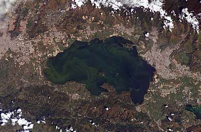
The lake suffers from algal blooms caused by continual influx of untreated wastewater from the surrounding urban, agricultural, and industrial land uses. This contributes to ongoing eutrophication, contamination, and salinization of the lake.
Despite its picturesque location between the Cordillera de la Costa to the north and the Serrania del Interior to the south, Lake Valencia's poor water quality limits opportunities for tourism and recreational activities. Due to pollution and other human induced changes, almost 60% of the native fish species in the lake were lost between 1960 and 1990.[4] Among the fish in the lake is the diamond tetra, which is commonly kept in aquaria, while two species of catfish, Lithogenes valencia and Pimelodella tapatapae are entirely endemic to the lake basin.[5]
References
- Chisholm, Hugh, ed. (1911). . Encyclopædia Britannica. 27 (11th ed.). Cambridge University Press. p. 846.
- Wulf, Andrea (15 September 2015). The Invention of Nature: Alexander von Humboldt's New World (Later Printing Used ed.). Knopf. pp. 59. ISBN 9780385350662.
- Humboldt, Alexander Von (1814). "AH Personal Narrative". Personal: 143–144.
- López-Rojas, H., and A. L. Bonilla-Rivero (2000) Anthropogenically induced fish diversity reduction in Lake Valencia Basin, Venezuela. Biodiversity & Conservation 9(6): 757–765
- Hales, J., and P. Petry (2013). Orinoco High Andes Archived 2017-01-16 at the Wayback Machine. Freshwater Ecoregions of the World. Retrieved 5 March 2013
Sources
| Wikimedia Commons has media related to Lake Valencia. |
- "Lake Valenica, Venezuela". NASA Earth Observatory. Retrieved 18 May 2006.