Lake Rotomahana
Lake Rotomahana is an 800-hectare (2,000-acre)[1] lake in northern New Zealand, located 20 kilometres to the south-east of Rotorua. It is immediately south-west of the dormant volcano Mount Tarawera, and its geography was substantially altered by a major 1886 eruption of Mount Tarawera. Along with the mountain, it lies within the Okataina caldera.
| Lake Rotomahana | |
|---|---|
 Black swan on Lake Rotomahana | |
| Location | North Island |
| Coordinates | 38°16′S 176°27′E |
| Lake type | crater lake |
| Primary outflows | none |
| Basin countries | New Zealand |
| Max. length | 6.2 km (3.9 mi)[1] |
| Max. width | 2.8 km (1.7 mi)[1] |
| Surface area | 8.0 km2 (3.1 sq mi)[1] |
| Average depth | 51 m (167 ft)[1] |
| Max. depth | 112.4 m (369 ft)[1] |
| Surface elevation | 337 m (1,106 ft)[2] |
| References | [1] |
| Lake Rotomahana | |
|---|---|
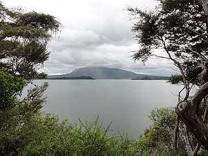 Lake Rotomahana in 2011 | |
| Elevation | 337 m (1,106 ft) |
| Naming | |
| Etymology | Hot Lake |
| Geography | |
| Location | Bay of Plenty Region, New Zealand |
| Geology | |
| Mountain type | volcanic crater lake |
| Type of rock | basalt |
| Volcanic arc | Taupo Volcanic Zone |
| Last eruption | 1987 |
The New Zealand Ministry for Culture and Heritage gives a translation of "warm lake" for Rotomahana, following Hochstetter.[3][4]
Before the 1886 eruption, only two small lakes were present in the current lake's basin. Following the eruption, a number of craters filled over the course of 15 years to form today's Lake Rotomahana. It is the most recently formed larger natural lake in New Zealand, and the deepest in the Rotorua district. The lake's northern shore lies close to the 39 metres (128 ft) lower Lake Tarawera, separated by less than 700 metres (2,300 ft) of terrain that is mostly material from the 1886 eruption. Lake Rotomahana has no natural outlet, and its water level varies by about one meter in response to rainfall and evaporation.[5]
The lake is a wildlife refuge (and was one prior to first contact), with all hunting of birds prohibited. A healthy population of black swan inhabits the lake, and there are efforts underway to ensure the lake's largest island, Patiti Island, is kept pest-free.[6] Recent research confirms Patiti Island is the closest surviving pre-eruption feature on the old lake, i.e. to survive the 1886 eruption, being formerly known as Rangipakaru Hill.[7] There is no public access to the lake, save for the Tourist Track, overland from Lake Tarawera.
A boat cruise on the lake, visiting hydrothermal features on the lake's shore, is available as an additional extra from the Waimangu Volcanic Valley tourism operation.

Pink and White Terraces
The Pink and White Terraces were a natural wonder on the shores of the lake before the 1886 eruption. They were considered to be the eighth wonder of the natural world and were New Zealand's most famous tourist attraction during the 19th century, from c. 1870-1886; but were buried or destroyed by the eruption.[8]
Scientists thought they had rediscovered the lower tiers of the Pink and White Terraces on the lake bed at a depth of 60 metres (200 ft) in 2011.[9] More recent research reports over 2016-2020 suggest the upper parts of both terraces lie on land and may therefore be accessed for physical evidence the terraces or sections of them survived in their original locations.[10][11][12]
The 2017- research relied on the journals of German-Austrian geologist Ferdinand von Hochstetter, who visited the lake in 1859.[13] Hochstetter's journals are the only known survey of the terraces before the eruption.[14] Using Hochstetter's field diaries and compass data, a team of New Zealand researchers identified a location where they believe the Pink and White Terraces lie preserved at a depth of 10–15 metres (32–49 ft).[15] The researchers were hoping to raise funds for a full survey of the area, but any work would first have to be approved by the local Maori tribe on whose sacred ancestral land the Pink and White Terraces are situated.[16][14][17] Ground penetrating radar searches were undertaken in 2017 but the equipment failed to penetrate sufficiently deeply to show whether or not the Terraces lay in their surveyed locations. [18] Later Hochstetter survey research refined the Pink, Black and White Terrace locations.[19][20]
Green Lake
A small lake, Green Lake, lies close to the eastern shore of Lake Rotomahana at 38°15′00″S 176°28′18″E. It should not be confused by the much larger Lake Rotokakahi (Green Lake), which lies to the west of Rotomahana.
Green Lake was formed in a roughly circular crater and is some 100 metres in diameter. It takes its name from its distinctive colour, which is considerably greener and darker than that of Rotomahana. The lake formed after the 1886 eruption of Mount Tarawera. Prior to the eruption, a small (~12m diameter) lakelet also known as Green Lake (Lake Rotopounamu) had existed to the north of Lake Rotomahana in Waikanapanapa Valley but this was exhumed during the Tarawera eruption. After the eruption, water flowed into the new Green Lake crater, which was given the same name as the older lake.[21] Other pre-eruption lakes and lakelets about Lake Rotomahana included Lakes Rotomakariri, Rangipakaru, Ruahoata and Wairake. The shape, location and orientation of Lake Makariri in Cole, 1970 (cited herein) is incorrect. He followed August Petermann's flawed map. Hochstetter shows the lake axis lay at an azimuth of 355 degrees.[22] Recent research into these lake levels gave insight into changes at Lake Rotomahana in the lead-up to the eruption.[23]
The Sunken Totara Forest Myth
One forgotten lake feature is the semi-mythical sunken totara forest of Lake Rotomahana.[24] In 2016 when a scuba team first dove the lake, they found no evidence of a sunken forest or trees, as reported by Fitzgerald off Moura.[25][26] While there were forests over the pre-eruption Mt Tarawera, Totara trees were scattered and only recorded over the western and southern mountain flanks.[27] Given Totara tree groves could hardly appear in the eruption craters; it appears likely any sunken forest lies in the north-east corner of the new lake.
The placement of the sunken forest would have been post-eruption, via the mechanism described by the US Forest Service after the Mt. St. Helens eruption.[28] The trees were uprooted in the eruption and propelled into the crater during or after the eruption. As the new lake formed over decades, the trunks floated for a time, then tipped vertically; later descending into a vertical lie, and became embedded into the lake floor coming to resemble a sunken forest. Hence, another myth about the Tarawera eruption and Lake Rotomahana is explained.
References
- Lowe, D.J.; Green, J.D. (1987). Viner, A.B. (ed.). Inland waters of New Zealand. Wellington: DSIR Science Information Publishing Centre. pp. 471–474. ISBN 978-0-477-06799-7.
- LINZ Topo50 Map BF37
- "1000 Māori place names". New Zealand Ministry for Culture and Heritage. 6 August 2019.
- Hochstetter, Ferdinand (1867). New Zealand. Stuttgart: Cotta. pp. 393–394.
- Information panel at Lake Rotomahana's shore
- "Patiti Island Environmental Restoration". Waimangu Volcanic Valley. Retrieved 2014-12-30.
- Bunn R (2020) Commentary: Locating Relict Sinter Terrace Sites at Lake Rotomahana, New Zealand, With Ferdinand von Hochstetter’s Legacy Cartography, Historic Maps, and LIDAR. Front. Earth Sci. 8:68. doi: 10.3389/feart.2020.00068
- "Eighth wonder of world 'rediscovered' in New Zealand". The Independent. 2017-06-12. Retrieved 2018-03-30.
- Wylie, Robin (28 April 2016). "A natural wonder lost to a volcano has been rediscovered". earth. BBC.
- Bunn, Rex; Nolden, Sascha (2017-06-07). "Forensic cartography with Hochstetter's 1859 Pink and White Terraces survey: Te Otukapuarangi and Te Tarata". Journal of the Royal Society of New Zealand. 0: 39–56. doi:10.1080/03036758.2017.1329748. ISSN 0303-6758.
- Bunn & Nolden, Rex & Sascha (December 2016). "Te Tarata and Te Otukapuarangi: Reverse engineering Hochstetter's Lake Rotomahana Survey to map the Pink and White Terrace locations". Journal of New Zealand Studies. NS23: 37–53.
- Bunn R (2020) Commentary: Locating Relict Sinter Terrace Sites at Lake Rotomahana, New Zealand, With Ferdinand von Hochstetter’s Legacy Cartography, Historic Maps, and LIDAR. Front. Earth Sci. 8:68. doi: 10.3389/feart.2020.00068
- Jennings, Ken. "Did the 8th Wonder of the World Survive?". Condé Nast Traveler. Retrieved 2018-03-30.
- "The Quest to Rediscover New Zealand's Lost Pink and White Terraces". Atlas Obscura. 2017-09-06. Retrieved 2018-03-30.
- Roy, Eleanor Ainge (2017-06-12). "Lost natural wonder in New Zealand may be found, say researchers". the Guardian. Retrieved 2018-03-30.
- "The missing eighth wonder of the world has been found". NewsComAu. Retrieved 2018-03-30.
- "Pink and White Terraces discovery announcement premature, says iwi". Stuff. Retrieved 2018-03-30.
- "Surveying+Spatial September 2019 : Survey Spatial New Zealand". www.surveyspatialnz.org. Retrieved 2019-12-27.
- "Surveying+Spatial June 2018 : Survey Spatial New Zealand". www.surveyspatialnz.org. Retrieved 2019-12-27.
- Bunn, A. R. (2019). Hochstetter’s survey of the Pink and White Terraces: the final iteration. Surveying+Spatial 99, 30–35.
- Cole, J. W., (1970) "Structure and eruptive history of the Tarawera volcanic complex", New Zealand Journal of Geology and Geophysics 13, 4. pp. 879–902.
- Fisher, C.F.; Petermann, August Heinrich; von Hochstetter, Ferdinand (1864). The geology of New Zealand in explanation of the geographical and topographical atlas of New Zealand : also, lectures by Dr F. Hochstetter delivered in New Zealand. Auckland, New Zealand: T. Delattre. doi:10.5962/bhl.title.155224.
- "Surveying+Spatial June 2018 : Survey Spatial New Zealand". www.surveyspatialnz.org. Retrieved 2019-12-27.
- Marsh, Sid (1991). Divers Tales. Wellington: Reed. p. 58.
- Fitzgerald, Herbert (2014). The Pink and White Terraces Revisited, Rotorua. Levin, New Zealand.: H. F. Fitzgerald.
- Bunn, A. R. Quest for the Pink and White Terraces, rushes, 7.30-8.30, https://www.youtube.com/watch?v=L9YHJjPTrX8, uploaded 6/5/2016.
- Nicholls, J.L. (1963). "Vulcanicity and indigenous vegetation in the Rotorua district". Proceedings of the N.Z. Ecological Society. 10: 58–65.
- Walker, T. (2017) “Learning the Lessons of Mount St Helens”, Creation 39, 3, 26
External links
| Wikimedia Commons has media related to Lake Rotomahana. |