Lake Ram
Lake Ram (Arabic: بحيرة مسعدة, "Buhairat Mas'ade", lit. Lake of Mas'ade; also Birkat el-Ram. Hebrew: בריכת רם, "Brekhat Ram") is a crater lake (maar) in the northeastern Golan Heights, near Mount Hermon, in Israel. Josephus knew it by the name Lake Phiala.[1] The sources of the lake are rain water and an underground spring. The lake has no outlet. It is known in Hebrew as "Brekhat Ram" (also written Berekhat Ram), meaning high pool.[2] It is also called Birket Ram,[2] using the Arabic word for pond. The area is inhabited by the Druze community.[3]
| Lake Ram | |
|---|---|
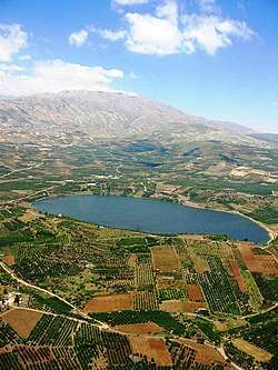 View with the lofty Mount Hermon beyond | |
| Location | Golan Heights, (disputed but under Israeli occupation) |
| Coordinates | |
| Type | crater lake (maar) |
| Primary inflows | precipitation, underground springs |
| Basin countries | Golan Heights |
Geology
Most geologists believe that the lake formed inside the crater of an extinct volcano.[3]
Archaeology
During excavations evidence was discovered of Palaeolithic human and hominid activity. Most notably, excavation led to the discovery of the Venus of Berekhat Ram, a pebble allegedly worked by Homo erectus. The artefact has been claimed to be the oldest known example of representational art in the world.[4] The pebble was found in a context datable to at least 230,000 years before present time, thus to the early Middle Palaeolithic. The claim that it is the earliest manifestation of human art is contested on multiple grounds (see article).
The site has been excavated for evidence of human activity during its history. Research on lacustrine sediments at the site concluded that the area has been heavily settled four times over history, first during the early Bronze Age, secondly during the Hellenistic and Roman–Byzantine periods, thirdly during the period of medieval Crusader rule, and finally in modern times. Between these periods the area became overgrown as local woodland regenerated, evidencing phases of low human occupation.[4]
Legends
According to The Talmud, Sanhedrin 108a, Brekhat Ram is one of three underground springs, along with Hamat Gader in the southeastern Golan Heights and Hamat Tiberias, that opened up in the Flood of Noah and didn't close up again after the flood.[5]
In a local Druze legend the lake is the "eye" of the "sheikh's wife", the name for a hill nearby. Mount Hermon (in Arabic Jabal al-Shaykh, "Mountain of the Sheikh"), referred to as the sheikh himself, is supposed to have been separated from the "wife", whereupon her eye filled with tears.[3]
References
- Ulrich Jasper Seetzen, Brief Account of the Countries adjoining the Lake of Tiberias, Palestine Association of London: London 1810, p. 15
- The Vilnay Guide to Israel, Volume 2, Beit-Or-Vilnay, 1999, p.298.
- "Israel Ministry of Tourism Website". Archived from the original on 2014-03-27. Retrieved 2013-06-24.
- Schwab, M (2004). "Holocene palaeoecology of the Golan Heights (Near East): investigation of lacustrine sediments from Birkat Ram crater lake". Quaternary Science Reviews. 23 (16–17): 1723–1731. doi:10.1016/j.quascirev.2004.05.001.
- https://www.sefaria.org/Sanhedrin.108a.11?lang=bi&with=all&lang2=en