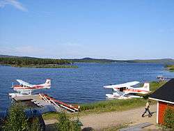
Lake Inari
Lake Inari (Finnish: Inarijärvi/Inarinjärvi, Northern Sami: Anárjávri, Inari Sami: Aanaarjävri, Skolt Sami: Aanarjäuʹrr, Swedish: Enare träsk, Norwegian: Enaresjøen) is the largest lake in Sápmi and the third-largest lake in Finland. It is located in the northern part of Lapland, north of the Arctic Circle. The lake is 117–119 metres (384–390 ft) above sea level, and is regulated at the Kaitakoski power plant in Russia. The freezing period normally extends from November to early June.
| Lake Inarijärvi | |
|---|---|
 | |
 | |
| Location | Inari, Lapland Province |
| Coordinates | 69°00′N 28°00′E |
| Primary outflows | Paatsjoki |
| Basin countries | Finland |
| Max. length | 80 km (50 mi) |
| Max. width | 50 km (31 mi) |
| Surface area | 1,040.28 km2 (401.65 sq mi)[1] |
| Average depth | 15 m (49 ft) |
| Max. depth | 96 m (315 ft) |
| Water volume | 15.9 km3 (12,900,000 acre⋅ft) |
| Shore length1 | 3,308 km (2,055 mi) |
| Surface elevation | 118.7 m (389 ft)[1] |
| Islands | 3318 (Hautuumaasaari, Ukonkivi) |
| Settlements | Inari |
| References | [1] |
| 1 Shore length is not a well-defined measure. | |
The best-known islands of the lake are Hautuumaasaari ("Graveyard Island"), which served as a cemetery for ancient Sami people, and Ukonkivi ("Ukko's Stone"), a historical sacrifice place of the ancient inhabitants of the area. There are over 3,000 islands in total. Trout, lake salmon, Arctic char, white fish, grayling, perch and pike are found in Lake Inari.
The lake covers 1,040 square kilometres (400 sq mi). It empties northwards through the Paatsjoki at the mouth of the Varangerfjord, which is a bay of the Barents Sea.
The lake depression is a graben bounded by faults active in the Cenozoic.[2]
References
- Inarijärvi. Järviwiki Web Service. Finnish Environment Institute. Retrieved 2014-03-07. (in English)
- Lindberg, Johan (February 2, 2011). "Lappland". Uppslagsverket Finland (in Swedish). Retrieved November 30, 2017.
External links

| Look up Inari in Wiktionary, the free dictionary. |