Lac d'Enghien
| Lac d'Enghien | |
|---|---|
| Location | Enghien-les-Bains, Île-de-France |
| Coordinates | 48°58′15″N 02°18′00″E |
| Primary outflows | rû d'Enghien |
| Catchment area | 70.38 km2 (27.17 sq mi) |
| Basin countries | France |
| Max. length | 930 m (3,050 ft) |
| Max. width | 350 m (1,150 ft) |
| Surface area | 43 ha (110 acres) |
| Average depth | 1.8 m (5 ft 11 in) |
| Max. depth | 2.55 m (8 ft 4 in) |
| Surface elevation | 43 m (141 ft) |
| Islands | 2 |
Lac d'Enghien is a freshwater lake in France.
Geography
Lac d'Enghien is in the Île-de-France region, approximately seven miles north of Paris. Administratively it belongs to the commune of Enghien-les-Bains in the department of Val-d'Oise. It is the department's largest body of water.[1]
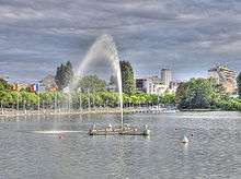
Fountain and pier at Lac d'Enghien
Features
The lake is roughly 350 metres (1,150 ft) wide and 930 metres (3,050 ft) long, with a circumference of 3.09 kilometres (1.92 mi) and a total surface area of 43 hectares (110 acres).[2] The lake water is replenished by several small streams: the Corbon, Haras, d'Ermont, and d'Andilly, all of them under 8 kilometres (5.0 mi) long .[3]
See also
References
- "Relief, géologie et hydrographie" (in French). Direction départementale des Territoires du Val d’Oise (DDT). 2009. Archived from the original on 29 September 2011. Retrieved 17 July 2011.
...lac d’Enghien, plan d’eau le plus important du département.
- "Joyau Naturel: Lac d'Enghien" (in French). Office de Tourisme, Enghien-les-Bain. 2011. Archived from the original on 13 October 2007. Retrieved 17 July 2011.
- "Fiche du bassin versant du lac d'Enghien" (in French). Institut d'amanagement et d'urbanisme de la region Île-de-France (IAURIF). 2007. Archived from the original on November 18, 2006. Retrieved 17 July 2011.
| Wikimedia Commons has media related to Lac d'Enghien. |
This article is issued from Wikipedia. The text is licensed under Creative Commons - Attribution - Sharealike. Additional terms may apply for the media files.