La Crosse, Indiana
La Crosse is a town in LaPorte County, Indiana, United States. The population was 551 at the 2010 census. It is included in the Michigan City, Indiana-La Porte, Indiana Metropolitan Statistical Area.
Town of La Crosse, Indiana | |
|---|---|
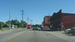 Downtown buildings | |
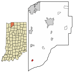 Location of La Crosse in LaPorte County, Indiana. | |
| Coordinates: 41°19′5″N 86°53′23″W | |
| Country | United States |
| State | Indiana |
| County | LaPorte |
| Area | |
| • Total | 0.53 sq mi (1.38 km2) |
| • Land | 0.53 sq mi (1.38 km2) |
| • Water | 0.00 sq mi (0.00 km2) |
| Elevation | 676 ft (206 m) |
| Population | |
| • Total | 551 |
| • Estimate (2018)[3] | 531 |
| • Density | 1,000.00/sq mi (386.10/km2) |
| Time zone | UTC-6 (CST) |
| • Summer (DST) | UTC-5 (CDT) |
| ZIP code | 46348 |
| Area code(s) | 219 |
| FIPS code | 18-40662[4] |
| GNIS feature ID | 0449678[5] |
History
La Crosse is derived from the French meaning "the crossing", and it was so named from its location at the junction or crossing of five railroads.[6][7] The La Crosse post office opened in 1921.[8]
Geography
La Crosse is located at 41°19′5″N 86°53′23″W (41.317924, -86.889831).[9]
According to the 2010 census, La Crosse has a total area of 341 square miles (883.19 km2), all land.[10]
Demographics
| Historical population | |||
|---|---|---|---|
| Census | Pop. | %± | |
| 1930 | 568 | — | |
| 1940 | 574 | 1.1% | |
| 1950 | 618 | 7.7% | |
| 1960 | 632 | 2.3% | |
| 1970 | 696 | 10.1% | |
| 1980 | 713 | 2.4% | |
| 1990 | 677 | −5.0% | |
| 2000 | 561 | −17.1% | |
| 2010 | 551 | −1.8% | |
| Est. 2018 | 531 | [3] | −3.6% |
| U.S. Decennial Census[11] | |||
.jpg)
2010 census
As of the census[2] of 2010, there were 551 people, 227 households, and 157 families living in the town. The population density was 1,039.6 inhabitants per square mile (401.4/km2). There were 243 housing units at an average density of 458.5 per square mile (177.0/km2). The racial makeup of the town was 99.5% White, 0.2% African American, and 0.4% from two or more races. Hispanic or Latino of any race were 1.8% of the population.
There were 227 households of which 29.1% had children under the age of 18 living with them, 52.9% were married couples living together, 9.7% had a female householder with no husband present, 6.6% had a male householder with no wife present, and 30.8% were non-families. 26.0% of all households were made up of individuals and 11.9% had someone living alone who was 65 years of age or older. The average household size was 2.43 and the average family size was 2.91.
The median age in the town was 36.4 years. 22.7% of residents were under the age of 18; 8.7% were between the ages of 18 and 24; 27.8% were from 25 to 44; 30% were from 45 to 64; and 10.7% were 65 years of age or older. The gender makeup of the town was 49.2% male and 50.8% female.
2000 census
As of the census[4] of 2000, there were 561 people, 221 households, and 152 families living in the town. The population density was 1,040.0 people per square mile (401.1/km²). There were 234 housing units at an average density of 433.8 per square mile (167.3/km²). The racial makeup of the town was 97.86% White, 0.18% African American, 0.36% Native American, 0.53% Asian, 0.18% Pacific Islander, and 0.89% from two or more races. Hispanic or Latino of any race were 2.50% of the population.
There were 221 households out of which 31.7% had children under the age of 18 living with them, 59.3% were married couples living together, 7.2% had a female householder with no husband present, and 31.2% were non-families. 28.5% of all households were made up of individuals and 13.1% had someone living alone who was 65 years of age or older. The average household size was 2.54 and the average family size was 3.10.
In the town, the population was spread out with 26.9% under the age of 18, 7.3% from 18 to 24, 28.9% from 25 to 44, 22.1% from 45 to 64, and 14.8% who were 65 years of age or older. The median age was 37 years. For every 100 females, there were 89.5 males. For every 100 females age 18 and over, there were 86.4 males.
The median income for a household in the town was $36,667, and the median income for a family was $50,278. Males had a median income of $34,583 versus $21,513 for females. The per capita income for the town was $17,962. None of the families and 1.5% of the population were living below the poverty line, including no under eighteens and 2.4% of those over 64.
Education
The town has a lending library, the La Crosse Public Library.[12]
References
- "2016 U.S. Gazetteer Files". United States Census Bureau. Retrieved Jul 28, 2017.
- "U.S. Census website". United States Census Bureau. Retrieved 2012-12-11.
- "Population and Housing Unit Estimates". Retrieved March 16, 2020.
- "U.S. Census website". United States Census Bureau. Retrieved 2008-01-31.
- "US Board on Geographic Names". United States Geological Survey. 2007-10-25. Retrieved 2008-01-31.
- Daniels, E. D. (1904). A twentieth century history and biographical record of La Porte County, Indiana. Lewis Publishing Co. p. 111.
- Baker, Ronald L. (October 1995). From Needmore to Prosperity: Hoosier Place Names in Folklore and History. Indiana University Press. p. 188. ISBN 978-0-253-32866-3.
Supposedly the name is French and means "The Crossing," descriptive of the location of the town at the junction...
- "La Porte County". Jim Forte Postal History. Retrieved 29 December 2014.
- "US Gazetteer files: 2010, 2000, and 1990". United States Census Bureau. 2011-02-12. Retrieved 2011-04-23.
- "G001 - Geographic Identifiers - 2010 Census Summary File 1". United States Census Bureau. Archived from the original on 2020-02-13. Retrieved 2015-07-17.
- "Census of Population and Housing". Census.gov. Retrieved June 4, 2015.
- "Indiana public library directory" (PDF). Indiana State Library. Retrieved 8 March 2018.
External links
Municipalities and communities of LaPorte County, Indiana, United States | ||
|---|---|---|
| Cities | Map of Indiana highlighting LaPorte County | |
| Towns | ||
| Townships | ||
| CDPs | ||
| Other unincorporated communities |
| |
| Footnotes | ‡This populated place also has portions in an adjacent county or counties | |
| Authority control |
|
|---|