Kyzylart Pass
Kyzylart Pass is a mountain pass and border crossing in the Trans-Alay Range on the border of Tajikistan and Kyrgyzstan. The highest point is 4,280 m (14,042 ft). Throughout the area, the land is typically rugged and dry. It is crossed by the Pamir Highway which leads south from Sary-Tash in the Alay Valley up onto the Pamir plateau toward Karakol Lake and Murghab, Tajikistan. In the late nineteenth century the Russians used to explore and eventually occupy the Pamir plateau.
| Kyzylart Pass | |
|---|---|
 Location in Tajikistan, on the border with Kyrgyzstan | |
| Elevation | 4,280 m (14,042 ft) |
| Location | Kyrgyzstan–Tajikistan border |
| Range | Trans-Alay Range |
| Coordinates | 39°23′03.60″N 73°19′21″E |
References
- Laurence Mitchell, Kyrgyzstan, Bradt travel guides, 2008
- Robert Middleton and Huw Thomas, Tajikistan and the High Pamirs, Odyssey Books, 2008
Gallery
.jpg) Ascent to the pass
Ascent to the pass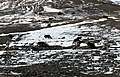 Yaki on the pass
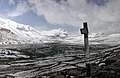 Kilometers on the pass
 Pamir Highway near the Kyzyl Art Pass
This article is issued from Wikipedia. The text is licensed under Creative Commons - Attribution - Sharealike. Additional terms may apply for the media files.