Kurram River
Kurram River (Pashto: د کورمې سيند) originates from watershed of Koh e sofaid in Kurram District, flows through North Waziristan District, Khyber Pakhtunkhwa, Pakistan and joins River Indus near Isa Khel. It drains the southern flanks of the Spin Ghar mountain range and is a right bank tributary of the Indus River.
| Kurram | |
|---|---|
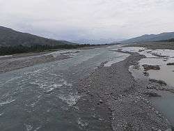 | |
 Course of the Kurram | |
| Native name | د کورمې سيند |
| Location | |
| Country | Afghanistan & Pakistan |
| province | Khyber Pakhtunkhwa |
| Region | Kurram Agency |
| Physical characteristics | |
| Source | |
| ⁃ location | 20 km southeast of Gardez, Paktia |
| Mouth | Indus River |
⁃ location | Isa Khel |
| Length | 320 km (200 mi) |
| Basin features | |
| Tributaries | |
| ⁃ right | Gambila |
Its tributaries include the Kirman River and the Khurmana River.[1][2]
The nearby Kurran-Garhi Project (finished in 1962) provides flood control and is used for irrigation and power.[3]
References
- Ali, Zulfiqar (6 June 2005). "Topographic survey of Kurram river planned". DAWN.COM. Retrieved 13 May 2018.
- "Geography". FATA - Official Web Portal. Archived from the original on 13 May 2018. Retrieved 13 May 2018.
- "Bannu". britannica.com.
See also
- Kurram Valley
This article is issued from Wikipedia. The text is licensed under Creative Commons - Attribution - Sharealike. Additional terms may apply for the media files.