Kori Creek
The Kori Creek is a tidal creek in the Kutch region of the Indian state of Gujarat. It lies just to the west of the Great Rann of Kutch area of India. This region belonging to India is a part of the Indus River Delta which lies across Gujarat state in India and Sindh in Pakistan.
| Kori Creek | |
|---|---|
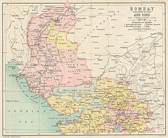 Location of Kori Creek in British Colonial era map | |
| Physical characteristics | |
| Mouth | |
⁃ location | Indian ocean |
⁃ coordinates | |
| Basin features | |
| River system | Indus river delta |
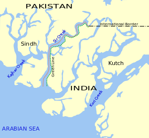
The Sir Creek, laying around 33 km northwest of Kori Creek, is a disputed area between India and Pakistan.
Geography
On the border of India and Pakistan in Gujarat at the mouth of Indus river the Kori Creek is one of the six main creeks on the Indian side. Other all other five are to the west of it, namely Sir Creek - the western most creek, Vian Wari Creek (Vianbari and Viyanbari), Pir Sanai, Pabevari, and Padala 16 km west.[1][2] All of these creeks are within undisputed territory of India, except westernmost creek, i.e. the Sir Creek, is claimed by both India and Pakistan. evershifting creeks, exit Indian territory, enter Pakistan, reenter India and vice versa, thus creating hard to patrol snake and scorpions infested marshy wetland border with no physical barrier or fencing.Indian military's Border Security Force (BSF) patrols the Kori Creek and Sir Creek up to midstream using floating border posts, amphibious vehicles, and foot travel by the Creek Crocodile Commandos. The coastal area of Sir Creek is manned by the Indian Coast Guard and larger open sea beyond is patrolled by the Indian Navy.[2]
See also
References
- 21 months on, BSF still bereft of hi-tech tools to fight nature, The Tribune, 2015.
- Away from the LoC, how BSF has secured the natural border between Gujarat and Pakistan, Economic TImes 13 July 2018.