Kondul Island
Kondul Island is a small island of the Nicobar Islands in India.
| Native name: Tamengshe | |
|---|---|
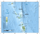
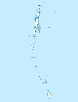 Kondul Island Location of Kondul Island in the Andaman and Nicobar Islands | |
| Geography | |
| Location | Bay of Bengal |
| Coordinates | 7.215°N 93.715°E |
| Archipelago | Nicobar Islands |
| Adjacent bodies of water | Indian Ocean |
| Total islands | 1 |
| Major islands |
|
| Area | 1.55 km2 (0.60 sq mi)[1] |
| Length | 2.6 km (1.62 mi) |
| Width | 1 km (0.6 mi) |
| Coastline | 7.5 km (4.66 mi) |
| Highest elevation | 92 m (302 ft) |
| Highest point | Tamengshe[2] |
| Administration | |
| District | Nicobar |
| Island group | Nicobar Islands |
| Subdivisions of India | Great Nicobar Subdivision |
| Taluk | Little Nicobar |
| Largest settlement | Mayaiya (pop. 2) |
| Demographics | |
| Population | 2 (2016) |
| Pop. density | 1.3/km2 (3.4/sq mi) |
| Ethnic groups | Hindu, Nicobarese |
| Additional information | |
| Time zone | |
| PIN | 744301 |
| Telephone code | 03192 |
| ISO code | IN-AN-00[3] |
| Official website | www |
| Literacy | 84.4% |
| Avg. summer temperature | 32.0 °C (89.6 °F) |
| Avg. winter temperature | 28.0 °C (82.4 °F) |
| Sex ratio | ♂/♀ |
| Census Code | 35.638.0002 |
| Official Languages | Hindi, English, Tamil Car (regional) |
History
It was hit by the 2004 tsunami. After the tsunami the surviving population moved to Great Nicobar.[4] at 2015 2 elders have returned to the island and they renovated the jetty. Poachers from Myanmar are doing illegal fishing around the island regularly.[5] []
Geography
The island is located in the Bay of Bengal, halfway between Great Nicobar and Little Nicobar in the St. George's Channel, and measures 2.6 km long and 0.95 km of maximum width for an area of 1.55 km2 (0.60 sq mi).
Climate
| Climate data for Kondul Island (1981–2010, extremes 1953–2003) | |||||||||||||
|---|---|---|---|---|---|---|---|---|---|---|---|---|---|
| Month | Jan | Feb | Mar | Apr | May | Jun | Jul | Aug | Sep | Oct | Nov | Dec | Year |
| Record high °C (°F) | 31.8 (89.2) |
38.4 (101.1) |
36.2 (97.2) |
35.2 (95.4) |
35.0 (95.0) |
33.6 (92.5) |
36.0 (96.8) |
32.5 (90.5) |
32.0 (89.6) |
31.8 (89.2) |
32.6 (90.7) |
32.4 (90.3) |
36.0 (96.8) |
| Average high °C (°F) | 28.9 (84.0) |
29.1 (84.4) |
30.1 (86.2) |
30.7 (87.3) |
30.7 (87.3) |
30.6 (87.1) |
30.2 (86.4) |
29.8 (85.6) |
29.4 (84.9) |
28.9 (84.0) |
28.8 (83.8) |
29.0 (84.2) |
29.7 (85.5) |
| Average low °C (°F) | 24.2 (75.6) |
24.2 (75.6) |
24.5 (76.1) |
23.9 (75.0) |
24.3 (75.7) |
24.3 (75.7) |
24.4 (75.9) |
23.7 (74.7) |
23.4 (74.1) |
23.5 (74.3) |
23.6 (74.5) |
24.1 (75.4) |
24.0 (75.2) |
| Record low °C (°F) | 18.0 (64.4) |
19.2 (66.6) |
19.0 (66.2) |
17.4 (63.3) |
17.0 (62.6) |
14.6 (58.3) |
15.2 (59.4) |
14.0 (57.2) |
14.2 (57.6) |
16.4 (61.5) |
16.2 (61.2) |
15.4 (59.7) |
14.0 (57.2) |
| Average rainfall mm (inches) | 111.0 (4.37) |
70.1 (2.76) |
78.1 (3.07) |
121.0 (4.76) |
255.5 (10.06) |
214.0 (8.43) |
247.4 (9.74) |
252.2 (9.93) |
297.6 (11.72) |
289.4 (11.39) |
271.8 (10.70) |
249.5 (9.82) |
2,457.7 (96.76) |
| Average rainy days | 5.9 | 3.5 | 4.7 | 5.4 | 11.7 | 10.7 | 12.1 | 13.4 | 12.8 | 13.2 | 12.9 | 8.8 | 115.1 |
| Average relative humidity (%) (at 17:30 IST) | 84 | 84 | 83 | 86 | 88 | 87 | 88 | 86 | 87 | 90 | 89 | 87 | 86 |
| Source: India Meteorological Department[6][7] | |||||||||||||
Administration
The island belongs to the township of Great Nicobar of Little Nicobar Taluk.[8]
Demographics
Mayaiya village is inhabited and has a radio antenna.
Image gallery
 Map
Map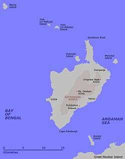 Map 2
Map 2
References
- "Islandwise Area and Population - 2011 Census" (PDF). Government of Andaman.
- info
- Registration Plate Numbers added to ISO Code
- Info
- News
- "Station: Kondul Climatological Table 1981–2010" (PDF). Climatological Normals 1981–2010. India Meteorological Department. January 2015. pp. 425–426. Archived from the original (PDF) on 5 February 2020. Retrieved 8 February 2020.
- "Extremes of Temperature & Rainfall for Indian Stations (Up to 2012)" (PDF). India Meteorological Department. December 2016. p. M2. Archived from the original (PDF) on 5 February 2020. Retrieved 8 February 2020.
- Tehsils

This article is issued from Wikipedia. The text is licensed under Creative Commons - Attribution - Sharealike. Additional terms may apply for the media files.