Kolar Gold Fields
Kolar Gold Fields or K.G.F. is a mining region located in K.G.F. taluk, Kolar District, Karnataka, India. Its headquarters are in Robertsonpet, where there is a township also called K.G.F., where families of the employees of Bharat Gold Mines Limited (BGML) and BEML (formerly Bharat Earth Movers Limited) reside. K.G.F. is about 30 kilometres (19 mi) from Kolar, 29 kilometres (18 mi) from Kuppam and 100 kilometres (62 mi) from Bangalore. For over a century the town has been known for gold mining. The mine was eventually closed on February 28, 2001, due to the inflation of gold rates, despite gold still being present in its mines. One of India's first power generation units was created to support operations of the K.G.F. in 1889.
Kolar Gold Fields ಕೋಲಾರ ಚಿನ್ನದ ಗಣಿ ಪ್ರದೇಶ Kolar Gold Mine | |
|---|---|
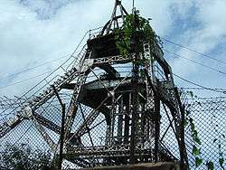 Champion Reef mine shaft at Kolar Gold Fields | |
 Kolar Gold Fields Location in Karnataka, India | |
| Coordinates: 12.961736°N 78.270721°E | |
| Country | |
| State | Karnataka |
| District | Kolar district |
| Government | |
| • Body | Robertsonpet City Municipal Council |
| Area | |
| • Total | 58.1234 km2 (22.4416 sq mi) |
| Elevation | 848 m (2,782 ft) |
| Population (2011) | |
| • Total | 163,643 |
| • Density | 2,800/km2 (7,300/sq mi) |
| Languages | |
| • Official | Kannada |
| Time zone | UTC+5:30 (IST) |
| PIN | 563115 -563122 |
| Telephone code | 08153 |
| Vehicle registration | KA 08 |
| Nearest city | Bangalore, Kolar, Kuppam, Krishnagiri |
| Lok Sabha constituency | Kolar |
| Vidhan Sabha constituency | K.G.F. |
| Avg. summer temperature | 32 °C (90 °F) |
| Avg. winter temperature | 12 °C (54 °F) |
| Website | http://www.robertsonpetcity.gov.in |

History
The early history of the Kolar Gold Fields was compiled by Fred Goodwill, Superintendent of the Wesleyan Tamil Mission, Bangalore and Kolar Gold Fields. His studies and observations have been published in the quarterly journals of the Mythic Society and other academic journals.[1][2][3]
The Gangas founded Kolar in the 2nd Century. For as long as they were in power, which was nearly a thousand years, they took the title 'Kuvalala-Puravareshwara' (the Lord of Kolar) even after they had shifted their capital to Talakadu from Kolar, and later from Talakadu, the Gangas ruled over Gangavadi comprising the southern districts of the Kannada people.[4]
The records are clear that Kolar came under Chola rule in 1004 for the first time. Following their usual naming system, the Cholas gave the name Nikarilichola-mandala to the district. In around 1117 AD, the Hoysalas under Vishnuvardhana captured Talakad and among his conquests, he captured Kolar and drove the Cholas from Mysore state. On the death of Somesvara, in 1254, a partition of Hoysala dominions took place between his two sons, and the Kolar district was included with the provinces to the share of Ramanatha. However, the next king Ballala III reunited the Hoysala dominions.
Kolar is much older than Bangalore, its origin going back to the 2nd century AD. Gangas made Kolar their capital and ruled over Mysore, Coimbatore, Salem and Trave. In the 13th Century AD, Sage Bhavanandi composed his treatise on Tamil grammar Nannool at the Ulagamadhi cave at KGF, under the patronage of Seeya Gangan one of the Ganga rulers who was born in Kolar and was a patron of arts and literature. Further Seeya Gangan's inscriptions indicate that Kolar regained control of Kolar for the second time from Chola hands.
During the reign of the Cholas, King Uththama Chola (970 AD) is said to have built the temple for Goddess Renuka. The Chola rulers Veera Chola, Vikrama Chola and Raja Nagendra Chola erected stone structures with inscriptions at Avani, Mulbagal, Sitti Bettta and other places. Chola inscriptions also indicate the rule of Adithya Chola I (871-907 AD), Raja Raja Chola I and Rajendra Chola I over Kolar. These inscriptions refer to Kolar as 'Nikarili Cholamandalam' and also as 'Jayam Konda Chola Manadalam'. Inscriptions of Rajendra Chola I also appear on the Kolaramma Temple. Many Siva temples were built in Kolar during the reign of the Cholas, such as the Someshwarar Temple at Marikuppam Village, Sri Uddhandeshwari Temple at Marikuppam Village, the Eswaran Temple at Oorugaumpet, the Sivan Temple at Madivala Village. The reign of the Cholas over Kolar lasted till 1116 AD. Sadly, the Chola inscriptions scattered all over Kolar lie neglected, and some subject to wilful cultural vandalism. According to B. Lewis Rice, this story is evidently based on some confused reminiscence of certain names and historical events. From the records of the period, we know that the Cholas subverted the power of the Gangas by the capture of Talakad in about 1004 and speedily possessed themselves of all the south and east of Mysore. The important city of Kolahala, or Kolar, thus became subject to them, together with the whole of the present Kolar District.
In 1117 AD, Kolar came under the reign of the Hoysalas, and in 1254 AD, the dominions were portioned among the two sons of King Someshwara, with Kolar included in the provinces that went to Ramanatha. The next king, Ballala III, however, reunited the Hoysala dominions.
The Hoysala were defeated by the Vijaynagar Kingdom, and their rule over Kolar lasted from 1336-1664. During their reign, the Sri Someshwara Temple at Kolar was built. During this time, in 1418, Thimme Gowda of the Morasu Vokkalu clan struck a treaty with the Vijayanagar Kings and ruled the Kolar District. His successors ruled for over four generations.
In the 17th Century, Kolar came under Maratha rule as part of the Jahagir of Shahaji for fifty years. Then under Muslim rule for seventy years. In 1720 AD, Kolar came under the Suba of Sira, with Fateh Mohammed, the father of Hyder Ali becoming the Faujdar of the province. After this Kolar passed through different reigns such as Marathas, the Nawab of Cuddapah, Nizam of Hyderabad and finally Hyder Ali. In 1768, Kolar came under British rule briefly till 1770, then passed briefly again to Maratha rule and again Hyder Ali. In 1791 Lord Cornwallis conquered Kolar, before passing it back to Mysore under the peace treaty of 1792. Kolar has been part of the Mysore State since that time.
Around the Kolar region, there are numerous inscriptions which indicate reign of the Mahavalis (Baanaas), Kadambas, Chalukyas, Pallava, Vaidumbaas, Rastrakutas, Cholas, Hoysalas and Mysore kings at different points of time.[1][2][3][5][6] Benjamin Lewis Rice recorded 1347 inscriptions in the Kolar District, in the 10th volume of Epigraphia Carnatica. Out of these inscriptions 714 inscriptions are in Kannada[7] 422 are in Tamil, 211 in Telugu.
In the year 1880 John Taylor III took control of some of the mines at KGF. John Taylor then proceeded to acquire other mining companies in KGF that were folding up due to a lack of success. During the years 1880 to 1956 the firm John Taylor & Sons ran the mines at KGF with considerable success. Under the parent company John Taylor & Sons many subsidiary mining companies were founded, with each subsidiary controlling separate mines. The earliest of these mining subsidiarys to be created was the Mysore Gold Mining Company. Other recognisable subsidiary mining companies which followed the Mysore Gold Mining company were the Ooregum and Nundydroog gold mining companies. Though many of these mines were initially being operated at a loss, in the year 1884 the champion load was discovered due to their persistence, with high-grade ores averaging 40 grams per tonne of quartz. By the year 1911, the champion reef mine had become the deepest mine in the world. With a depth of 3500m it held this title until the year 1956. Another considerable success was the electrification of the mines. In 1902 electricity was established at KGF through the implementation of a 140km long electricity cable that was laid by General Electric from the hydroelectric power plant at Shivanasamudra Falls to the mines at KGF. Mining operations were continued by the firm John Taylor & sons until the year 1956. After 1956 the government of Mysore which had taken over the mines employed John Taylor and sons as mining consultants for a number of years.
Birth of the city
With the growth of the Gold Mines and the resulting demand for labour, people from Dharmapuri, Krishnagiri, Salem, the North and South Arcot districts of Tamil Nadu and Chittoor, Madanapalli and Ananthapur districts of Andhra Pradesh, were settled around the various shafts.[8]
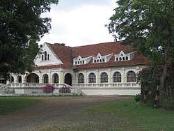
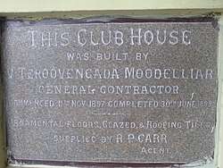
With time, the habitations expanded to merge into each other to form the outer reaches of the town of KGF. In the core of the town were the families of British and Indian engineers, geologists, and mine supervisors who lived a grand colonial lifestyle completed with golf course, tennis court, a club with dance halls and bars, cottages and Bungalows with gardens and quarters for the employees and churches and chapels.
The ruins of these structures and some memorabilia continue to exist even today. Many places in the area have names reminiscent of the Raj. The two main townships which came up subsequently in KGF were Robertsonpet and Andersonpet, named after two British officers in the mines.
In June 1902, electricity was supplied for the mining operations at KGF from India's first and oldest power generation plant which was called the 'Kaveri Electric Power Plant' from Shivanasamudra.[9]
Subsequent establishment of the BEML public sector enterprise brought further expansion to the city providing employment to existing populations while also bringing in new populations that added to the cosmopolitan nature of KGF.
Kolar National Geological Monument
Pyroclastics & Pillow lavas of Kolar Gold fields at Kolar Gold Fields(KGF) has been declared the National Geological Monuments of India by the Geological Survey of India (GSI), for their protection, maintenance, promotion and enhancement of geotourism.[10][11][12]
Climate
| Climate data for Kolar Gold Fields (1981–2010, extremes 1972–2002) | |||||||||||||
|---|---|---|---|---|---|---|---|---|---|---|---|---|---|
| Month | Jan | Feb | Mar | Apr | May | Jun | Jul | Aug | Sep | Oct | Nov | Dec | Year |
| Record high °C (°F) | 33.9 (93.0) |
35.1 (95.2) |
38.3 (100.9) |
39.7 (103.5) |
38.2 (100.8) |
38.5 (101.3) |
34.5 (94.1) |
33.4 (92.1) |
33.7 (92.7) |
32.5 (90.5) |
31.1 (88.0) |
29.9 (85.8) |
39.7 (103.5) |
| Average high °C (°F) | 26.4 (79.5) |
29.6 (85.3) |
32.5 (90.5) |
34.1 (93.4) |
34.0 (93.2) |
30.8 (87.4) |
29.6 (85.3) |
29.0 (84.2) |
29.3 (84.7) |
27.8 (82.0) |
26.3 (79.3) |
25.1 (77.2) |
29.5 (85.1) |
| Average low °C (°F) | 15.0 (59.0) |
16.4 (61.5) |
18.7 (65.7) |
21.3 (70.3) |
21.7 (71.1) |
20.6 (69.1) |
20.1 (68.2) |
19.8 (67.6) |
19.7 (67.5) |
19.2 (66.6) |
17.5 (63.5) |
15.8 (60.4) |
18.8 (65.8) |
| Record low °C (°F) | 10.0 (50.0) |
10.5 (50.9) |
12.4 (54.3) |
15.7 (60.3) |
17.5 (63.5) |
15.4 (59.7) |
17.3 (63.1) |
17.1 (62.8) |
16.2 (61.2) |
13.6 (56.5) |
12.0 (53.6) |
9.4 (48.9) |
9.4 (48.9) |
| Average rainfall mm (inches) | 3.5 (0.14) |
3.7 (0.15) |
19.4 (0.76) |
34.6 (1.36) |
98.4 (3.87) |
77.9 (3.07) |
81.7 (3.22) |
104.6 (4.12) |
212.4 (8.36) |
138.9 (5.47) |
76.7 (3.02) |
27.2 (1.07) |
879.1 (34.61) |
| Average rainy days | 0.3 | 0.4 | 1.2 | 2.4 | 5.5 | 3.9 | 4.9 | 6.3 | 8.0 | 7.4 | 5.1 | 2.2 | 47.6 |
| Average relative humidity (%) (at 17:30 IST) | 49 | 37 | 32 | 38 | 48 | 56 | 58 | 61 | 63 | 68 | 67 | 63 | 54 |
| Source: India Meteorological Department[13][14] | |||||||||||||
Education
In 1901, an English Medium Primary School was established by the John Taylor and Sons Company, at the Nandydoorg Mine, for providing education to the children of British and European workers of the company. It came to know as the Kolar Gold Fields Boys School Oorigaum, and was later upgraded to Middle School and then to High School, with the students appearing to Lower Cambridge and Senior Cambridge Level Exams. However this school was co-educational only up to Primary School, with girls being excluded after that.
To meet the educational requirements of girls in KGF, on 15 January 1904, the Sisters of St. Joseph of Tarbes established two schools in KGF - An English School for Europeans and Anglo Indians with 22 children. The school operated in the compound of St. Mary's Church, Champion Reefs, with Sis. Teresa of Jesus serving as Head Mistress and Y Gurupatham principal for both schools. Further, St. Mary's Boys School was established in the same St. Mary's Church compound. Funding was made available from the Mysore Government since 1927, with Rs.98 grant towards the English school. The English Convent subsequently developed into High School with Senior Cambridge Level. The St. Mary's Boys School was moved to Andersonpet after an airblast incident.
In 1933, the Order of the St. Joseph of Tarbes started the St. Theresa's School in Robertsonpet and then in 1943, the St. Sebastian's School at Coromandel. With both schools offering English instruction.[15]
To cater to the educational needs to the growing Marwai population at KGF, the Sumathi Jain High School was established in Robertsonpet.[16]
KGF has a Dental College which is KGF College of Dental Science & Hospital, an Engineering College which is Dr. T. Thimmaiah Institute of Technology(DR.TTIT) (Formerly known as Golden Valley Institute of Technology - GVIT), a law college- Sri Kengal Hanumanthaiya Law College, a PU college-KGF PU College, a degree college -KGF first Grade College, Sri Bhagawan Mahaveer Jain College Kgf. KGF also has the National Institute of Rock Mechanics (NIRM) which is run by the Ministry of Mines with the help of GSI and IBM, and Vijaylakshmi college.
Schools in the area include, St. Teresa's School, St. Joseph's School, St. Mary's School, St. Charles School, Nizamia School, Vani English High school and Higher Primary School, Sree Mahaveer Jain School, [[William Richards School, Kolar Gold Fields, India|William Richards School]], Edens English Higher Primary School, Momin Urdu School, Dr. Ambedkarhi Jain High School, Kendriya Vidyalaya BEML Nagar and BEML Composite Junior College (BCJC), Don Bosco Industrial Training Institute (I.T.I) Proposed Degree College KGF School of Commerce
Demographics
The official language is Kannada. In Kolar district Kannada is the mainly spoken language. However, Tamil & Telugu are spoken widely as well.[17] Most of the Tamil population trace their ancestry to labourers brought in by the British from the North Arcot, Chittoor, Salem and Dharmapuri districts of the Madras Presidency, during the late 19th century.[5][18][19]
There is also a substantial Anglo-Indian population and Arcot Mudaliar population at KGF, descendants of the mine supervisors.[15]
Closing of Kolar Gold Mines
The Kolar Gold mines were nationalized in 1956, and provided over 900 tonnes of Gold in total. However, they were closed by the Indian Government on 28th February 2001, due to environmental reasons, wrong pricing policy and lack of investment in new exploration. Also there were several problems regarding lack of food, water and shelter so the production was too less as compare to the investment in them . [20][21]
In popular culture
The place is the central plot of the Kannada-language blockbuster film K.G.F: Chapter 1 and its sequel K.G.F: Chapter 2.[22]
Kolar’s Gold is a mixed media project produced by cornish folk band The Rowan Tree[23] to tell the forgotten stories of Cornish miners, their families and their Indian counterparts who lived and worked at KGF from 1890-1940, and beyond. The first single off the album, 'And Am I Born To Die?[24]', was released on Nov 22, 2019.
See also
References
- Mythic Society (Bangalore, India) (1918). The Quarterly Journal of the Mythic Society. 9–10: iv, 5, 8, 300. Missing or empty
|title=(help) - Goodwill, Fred (1918). "Nandidroog". The Quarterly Journal of the Mythic Society. 9–10: 300. Retrieved 27 August 2014.
- Goodwill, Fred (1921). "The Religious and Military Story of Nudydurga". KGF Mining and Metallurgical Society (5).
- "Day Before KGF's Release, Bengaluru Court Orders Stay; Producer Says Movie will be Released". News18. 20 December 2018. Retrieved 17 May 2020.
- Srikumar, S (12 March 2014). Kolar Gold Field: (Unfolding the Untold) (International ed.). Partridge Publishing. pp. 40–46. ISBN 978-1482815078. Retrieved 27 August 2014.
- Chandrashekar, Gayatri (2015). Grit and Gold. Partridge Publishing. ISBN 9781482855845. Retrieved 11 July 2016.
- Rice, Benjamin Lewis (1994). Epigraphia Carnatica: Volume X: Inscriptions in the Kolar District. Mangalore, British India: Department of Archaeology, Mysore State. p. i. Retrieved 4 August 2015.
- "'KGF' team recreated gold mines from 70's at Real Kolar Gold Field - Times of India". The Times of India. Retrieved 17 May 2020.
- Iyer, Meera (21 June 2015). "Miscellany - A time capsule" (Bangalore). Deccan Herald. Retrieved 7 August 2015.
- "National Geological Monument, from Geological Survey of India website". Archived from the original on 12 July 2017. Retrieved 21 January 2019.
- "Geo-Heritage Sites". pib.nic.in. Press Information Bureau. 9 March 2016. Retrieved 15 September 2018.
- national geo-heritage of India, INTACH
- "Station: Kolar Gold Field Climatological Table 1981–2010" (PDF). Climatological Normals 1981–2010. India Meteorological Department. January 2015. pp. 421–422. Archived from the original (PDF) on 5 February 2020. Retrieved 19 April 2020.
- "Extremes of Temperature & Rainfall for Indian Stations (Up to 2012)" (PDF). India Meteorological Department. December 2016. p. M98. Archived from the original (PDF) on 5 February 2020. Retrieved 19 April 2020.
- White, Bridget (2010). Kolar Gold Fields - Down Memory Lane: Paeans to Lost Glory!. Central Milton Keynes: Author House. ISBN 978-1452051031. Retrieved 6 January 2015.
- White, Bridget (15 November 2010). "Tale of two thriving townships" (Bangalore). Deccan Herald. Retrieved 13 January 2015.
- "Data on Language and Mother Tongue". Censusindia.gov.in. Retrieved 25 August 2018.
- "Kolar Gold Fields: Land with Golden People". Blogspot. Retrieved 6 January 2015.
- Steve, Arul (April 2013). "Specialization On Social And Cultural Indifference Among KGF Tamil Migrants". ArulSteve736. Word Press. Retrieved 6 January 2015.
- White-kumar, Bridget (21 November 2014). "Kolar Gold Fields - NOSTALGIA: SOME IMPORTANT DATES IN THE HISTORY OF KOLAR GOLD FIELDS". Kolar Gold Fields - NOSTALGIA. Retrieved 22 December 2019.
- Feb 13, TNN |; 2017; Ist, 0:30. "Old KGF mines can never be reopened | Bengaluru News - Times of India". The Times of India. Retrieved 22 December 2019.CS1 maint: numeric names: authors list (link)
- "The Story of KGF: Cradle of India's Gold Rush". The Quint. 20 December 2018. Retrieved 3 April 2019.
- "About & FAQ's". The Rowan Tree. Retrieved 22 November 2019.
- And Am I Born To Die?, retrieved 22 November 2019
External links
| Wikimedia Commons has media related to Kolar Gold Fields. |
- Kolar Gold Fields archival video with annotations
- KGF
- {{PM20|FID=co/053274|TEXT=Documents and clippings about|NAME=Champion Reef Gold