Kohala Mountain Road
Kohala Mountain Road, designated Route 250, travels upon the Kohala mountain on the island of Hawaiʻi in Hawaii County, Hawaii, United States.
| ||||
|---|---|---|---|---|
| Kohala Mountain Road | ||||

Route 250 highlighted in red | ||||
| Route information | ||||
| Maintained by HDOT | ||||
| Length | 19.276 mi[1] (31.022 km) | |||
| Major junctions | ||||
| South end | ||||
| North end | ||||
| Location | ||||
| Counties | Hawaii | |||
| Highway system | ||||
Routes in Hawaii
| ||||

Route description
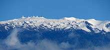
Mauna Kea Observatories in the distance, viewed from Kohala Mountain Road (telephoto)
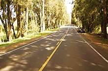
Ranch lands on both sides of a coniferous-lined Highway 250.
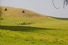
Views of ranch land may surprise some visitors to the Big Island. Looking southwest from the Kohala Mountain Road, Highway 250.
Kohala Mountain road, known locally as "the High Road", begins about 1.8 miles (2.9 km) west of Waimea, at 20°1′36″N 155°41′57″W, near the Hawaii Preparatory Academy campus. Route 19 at this point is known as Hawaii Belt Road, or Kawaihae Road. The northern terminus (where Route 250 is known as Hāwī Road), is in the town of Hāwī at 20°14′16″N 155°49′49″W,[2] at the intersection of ʻAkoni Pule Highway (Route 270).
Major junctions
The entire route is in Hawaii County.
| Location | mi[1] | km | Destinations | Notes | |
|---|---|---|---|---|---|
| Waimea | 0.000 | 0.000 | |||
| Hawi | 19.276 | 31.022 | |||
| 1.000 mi = 1.609 km; 1.000 km = 0.621 mi | |||||
References
- Hawaii Department of Transportation (October 2016). "State DOT Road Inventory" (ESRI Shapefile). Retrieved July 31, 2019.
- U.S. Geological Survey Geographic Names Information System: Hāwī
This article is issued from Wikipedia. The text is licensed under Creative Commons - Attribution - Sharealike. Additional terms may apply for the media files.