Klyuchi, Kamchatka Krai
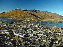
Klyuchi (Russian: Ключи́) is a rural locality (a settlement) in Ust-Kamchatsky District of Kamchatka Krai, Russia, located on the Kamchatka River, 30 kilometers (19 mi) to the north of Klyuchevskaya Sopka volcano. Population: 5,726 (2010 Census);[1] 7,073 (2002 Census);[2] 11,251 (1989 Census).[3].
Geography
The settlement is located near the point where the course of the Kamchatka River turns from north to east.
History
It was founded in 1731. In 1951, it was granted urban-type settlement status and in 1979—town status. In 2004, it was demoted to a rural locality in order to become eligible for increased funding from the Russian federal budget.
Military
Klyuchi, being in a very isolated part of the former Soviet Union, has been near an intercontinental ballistic missile testing range since the Cold War, the Kura Missile Test Range, and is served by Klyuchi air base just southwest of the town. Klyuchi's original airfield consisted of a dirt airstrip and was located 13 kilometres (8 mi) east-southeast of the town. It was abandoned in the 1960s[4] and is being reclaimed by forest.
Transportation
There is a road connecting Klyuchi to Petropavlovsk-Kamchatskiy. Driving, according to Google Maps, takes several hours.
Climate
Klyuchi has a typical subarctic climate (Köppen climate classification Dfc), albeit with slight dry-summer precipitation patterns.
| Climate data for Klyuchi | |||||||||||||
|---|---|---|---|---|---|---|---|---|---|---|---|---|---|
| Month | Jan | Feb | Mar | Apr | May | Jun | Jul | Aug | Sep | Oct | Nov | Dec | Year |
| Record high °C (°F) | 5.8 (42.4) |
3.7 (38.7) |
7.4 (45.3) |
17.4 (63.3) |
28.4 (83.1) |
30.0 (86.0) |
32.7 (90.9) |
29.6 (85.3) |
25.0 (77.0) |
17.7 (63.9) |
11.6 (52.9) |
5.3 (41.5) |
32.7 (90.9) |
| Average high °C (°F) | −12.9 (8.8) |
−9.3 (15.3) |
−3.6 (25.5) |
2.3 (36.1) |
9.8 (49.6) |
17.7 (63.9) |
20.7 (69.3) |
18.8 (65.8) |
13.7 (56.7) |
6.3 (43.3) |
−2.9 (26.8) |
−10.4 (13.3) |
4.2 (39.6) |
| Daily mean °C (°F) | −16.6 (2.1) |
−13.5 (7.7) |
−8.3 (17.1) |
−1.7 (28.9) |
5.2 (41.4) |
12.2 (54.0) |
15.6 (60.1) |
14.1 (57.4) |
9.1 (48.4) |
2.8 (37.0) |
−6.0 (21.2) |
−13.9 (7.0) |
−0.1 (31.8) |
| Average low °C (°F) | −20.4 (−4.7) |
−17.6 (0.3) |
−12.8 (9.0) |
−5.7 (21.7) |
1.0 (33.8) |
7.1 (44.8) |
11.1 (52.0) |
10.2 (50.4) |
5.1 (41.2) |
−0.3 (31.5) |
−9.1 (15.6) |
−17.5 (0.5) |
−4.1 (24.6) |
| Record low °C (°F) | −48.6 (−55.5) |
−42.0 (−43.6) |
−36.7 (−34.1) |
−26.5 (−15.7) |
−10.3 (13.5) |
−3.7 (25.3) |
2.3 (36.1) |
−1.3 (29.7) |
−7.2 (19.0) |
−19.3 (−2.7) |
−33.8 (−28.8) |
−42.2 (−44.0) |
−48.6 (−55.5) |
| Average precipitation mm (inches) | 68 (2.7) |
59 (2.3) |
48 (1.9) |
32 (1.3) |
30 (1.2) |
38 (1.5) |
49 (1.9) |
67 (2.6) |
50 (2.0) |
66 (2.6) |
65 (2.6) |
60 (2.4) |
632 (24.9) |
| Average rainy days | 0 | 0 | 0 | 0.3 | 8 | 16 | 17 | 19 | 17 | 12 | 1 | 0.2 | 110 |
| Average snowy days | 20 | 18 | 18 | 10 | 2 | 0. | 0 | 0 | 0 | 3 | 14 | 19 | 104 |
| Average relative humidity (%) | 83 | 80 | 75 | 70 | 68 | 70 | 77 | 81 | 79 | 76 | 79 | 84 | 77 |
| Source: Pogoda.ru.net[5] | |||||||||||||
References
- Russian Federal State Statistics Service (2011). "Всероссийская перепись населения 2010 года. Том 1" [2010 All-Russian Population Census, vol. 1]. Всероссийская перепись населения 2010 года [2010 All-Russia Population Census] (in Russian). Federal State Statistics Service.
- Russian Federal State Statistics Service (May 21, 2004). "Численность населения России, субъектов Российской Федерации в составе федеральных округов, районов, городских поселений, сельских населённых пунктов – районных центров и сельских населённых пунктов с населением 3 тысячи и более человек" [Population of Russia, Its Federal Districts, Federal Subjects, Districts, Urban Localities, Rural Localities—Administrative Centers, and Rural Localities with Population of Over 3,000] (XLS). Всероссийская перепись населения 2002 года [All-Russia Population Census of 2002] (in Russian).
- "Всесоюзная перепись населения 1989 г. Численность наличного населения союзных и автономных республик, автономных областей и округов, краёв, областей, районов, городских поселений и сёл-райцентров" [All Union Population Census of 1989: Present Population of Union and Autonomous Republics, Autonomous Oblasts and Okrugs, Krais, Oblasts, Districts, Urban Settlements, and Villages Serving as District Administrative Centers]. Всесоюзная перепись населения 1989 года [All-Union Population Census of 1989] (in Russian). Институт демографии Национального исследовательского университета: Высшая школа экономики [Institute of Demography at the National Research University: Higher School of Economics]. 1989 – via Demoscope Weekly.
- DETAILED REPORT OF KLYUCHI COMPLEX, USSR, September 26, 1963 (Top Secret, declassified June 8, 2000), Central Intelligence Agency, Washington D.C., 1963.
- "Pogoda.ru.net-Climate Data for Klyuchi 1981-2010". Retrieved November 12, 2012.
External links
- Unofficial website of Klyuchi (in Russian)