Klejnárka
The Klejnárka is a river which flows through the Central Bohemian Region of the Czech Republic. It is a left tributary of the Elbe (Czech: Labe). It is 40.3 kilometres (25.0 mi) long, and its basin area is 350 km2.[1]
| Klejnárka | |
|---|---|
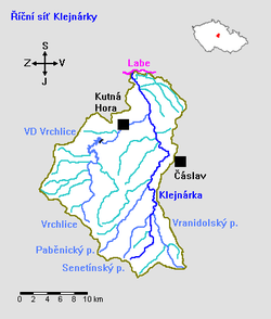 Map of the Klejnárka | |
| Location | |
| Country | Czech Republic |
| Physical characteristics | |
| Source | |
| • location | Dobrovítov, Kutná Hora District |
| • elevation | 516.5 m (1,695 ft) |
| Mouth | |
• location | The Elbe at Starý Kolín, Kolín District |
• coordinates | 50°01′14″N 15°16′24″E |
• elevation | 193.5 m (635 ft) |
| Length | 40.3 km (25.0 mi) |
| Basin size | 350 km2 (140 sq mi) |
| Discharge | |
| • average | 1.5 m3/s (53 cu ft/s) |
| Basin features | |
| Progression | Elbe→ North Sea |
The Klejnárka originates in the Bohemian-Moravian Highlands about 5 kilometres (3.1 mi) southwest of Zbýšov, near the village of Dobrovítov. It flows northward through the towns of Čáslav and Nové Dvory (where it is joined by its largest tributary, the Vrchlice). From here it flows another 6 kilometres (3.7 mi) northward to join the Elbe river in Starý Kolín.
References
- "Charakteristiky toků a povodí ČR - Klejnárka" (in Czech). VÚV TGM. Retrieved 2018-05-07.
| Wikimedia Commons has media related to Klejnárka. |
This article is issued from Wikipedia. The text is licensed under Creative Commons - Attribution - Sharealike. Additional terms may apply for the media files.