Kirby Underdale
Kirby Underdale is a village and civil parish in the East Riding of Yorkshire, England. It is situated approximately 6 miles (10 km) north of Pocklington town centre and lies 1 mile (1.6 km) north of the main A166 road from York to Driffield.
| Kirby Underdale | |
|---|---|
 Kirby Underdale Location within the East Riding of Yorkshire | |
| Population | 125 (2011 census)[1] |
| OS grid reference | SE806585 |
| • London | 175 mi (282 km) S |
| Civil parish |
|
| Unitary authority | |
| Ceremonial county | |
| Region | |
| Country | England |
| Sovereign state | United Kingdom |
| Post town | YORK |
| Postcode district | YO41 |
| Dialling code | 01759 |
| Police | Humberside |
| Fire | Humberside |
| Ambulance | Yorkshire |
| UK Parliament | |
The civil parish is formed by the village of Kirby Underdale and the hamlets of Garrowby, Painsthorpe and Uncleby. According to the 2011 UK Census, Kirby Underdale parish had a population of 125,[1] a decrease on the 2001 UK Census figure of 129.[2]
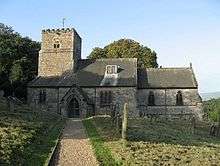
The church, dedicated to All Saints, was designated a Grade I listed building in 1987 and is now recorded in the National Heritage List for England, maintained by Historic England.[3]
In Baines 1823 History, Directory and Gazetteer of the County of York Kirby Underwood village and parish was listed as "Kirby Guderdale", and was in the Wapentake of Buckrose. All Saints' Church and its benefice was in the patronage of King George IV. Population at the time was 385, which included two farmers, one of whom was a butcher, a blacksmith, a grocer, and a carpenter. Included in the parish and its population was the hamlet of Garraby, 1 mile to the south-west, with two farmers and Sir F. L. Wood.[4]
Sir Francis Lindley Wood of Garrowby Hall and Hickleton Hall was lord of the manor and owner of most parish land, and provided a schoolmaster to teach poor parish children at Uncleby, a further parish hamlet 1 mile to the north of Kirby. One mile farther to the north was the parish hamlet of Hanging Grimston, and 1 mile to the south-east, that of Painsthorpe, where lived Rear-Admiral Charles Richardson. Population by 1840 was 293, with parish occupations that included twenty-one farmers, two wheelwrights, two shopkeepers, a tailor, a woodman, and a gamekeeper. Further residents were a schoolmaster and schoolmistress, a parish clerk, a yeoman, and the parish incumbent at the rectory.[5]
References
- UK Census (2011). "Local Area Report – Kirby Underdale Parish (1170211212)". Nomis. Office for National Statistics. Retrieved 21 February 2018.
- UK Census (2001). "Local Area Report – Kirby Underdale Parish (00FB083)". Nomis. Office for National Statistics. Retrieved 1 March 2020.
- Historic England. "Church of All Saints (1083837)". National Heritage List for England. Retrieved 11 August 2013.
- Baines, Edward (1823). History, Directory and Gazetteer of the County of York. pp. 209, 361.
- White, William (1840). History, Gazetteer and Directory of the East and North Ridings of Yorkshire. p. 347.
- Gazetteer — A–Z of Towns Villages and Hamlets. East Riding of Yorkshire Council. 2006. p. 7.
External links

- Kirby Underdale in the Domesday Book