Kirby Sigston
Kirby Sigston is a village and civil parish in the Hambleton district of North Yorkshire, England, approximately 4 miles (6.4 km) east of Northallerton.[1] The village is situated on Cod Beck,[2] and the wider parish contains the hamlet of Jeater Houses[3] due east of the village on the trunk A19 road.[4] The village is mentioned in the Domesday Book as having 75 ploughlands and its name derives from a combination of the Old Norse Kirkju-býr (a village with a church) and Siggs tūn ( Siggs farmstead or settlement).[5] Sigston is also the name of a village nearby.[6]
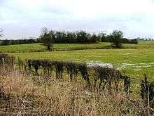

During the 14th century the parish was part of a huge deer park and hunting area on the eastern side of what is now known as the Vale of Mowbray.[7] A deserted medieval village (DMV) lies to the south of the church.[8]
The population taken at the 2011 Census was fewer than 100, so details are included in the civil parish of Winton, Stank and Hallikeld.[9] North Yorkshire County Council estimated the population of the village in 2015 to be 100 people, an increase of ten since the 2011 census.[10] The village has never had a shop, post office or pub, and its school, which opened in 1846 and would take around 35 pupils, closed down in 1944.[11][12]
To the north is the site of Sigston Castle, a fourteenth-century quadrangular castle, surrounded by a now largely dry moat.[13][14] South of Sigston Castle, near the grade II listed Manor House,[15] is St Lawrence’s church.[11] The church is largely Norman but the tower was renovated in the 18th century.[16] The grade I listed church is decorated with carvings of dragons, which Pevsner states shows the Danish influence in the area.[17]
Kirby Sigston is referred to in The Mountain Goats' song "Going to Kirby Sigston".[18]
Notable residents
The Conservative MP for Richmond (Yorks), Rishi Sunak, since 2020 UK Chancellor of the Exchequer, currently lives in Kirby Sigston.[19]
References
- "Genuki: Kirby Sigston, Yorkshire (North Riding)". www.genuki.org.uk. Retrieved 31 October 2019.
- "History of Kirby Sigston, in Hambleton and the North Riding | Map and description". www.visionofbritain.org.uk. Retrieved 31 October 2019.
- "Parishes: Kirkby Sigston | British History Online". www.british-history.ac.uk. Retrieved 31 October 2019.
- "302" (Map). Northallerton & Thirsk. 1:25,000. Explorer. Ordnance Survey. 2015. ISBN 978-0-319-24554-5.
- Ekwall, Eilert (1960). The concise Oxford dictionary of English place-names (4 ed.). Oxford: Oxford University Press. pp. 279, 422. ISBN 0-19-869103-3.
- Mills, A D (2011). A dictionary of British place-names. Oxford: Oxford University Press. p. 281. ISBN 9780199609086.
- National Character Area Profile 24: Vale of Mowbray. Natural Engand. 2015. p. 11. ISBN 978-1-84754-301-1.
- "Beresford's Lost Villages :: Site detail :: Sigston, Kirby". dmv.hull.ac.uk. Retrieved 31 October 2019.
- UK Census (2011). "Local Area Report – Winton, Stank and Hallikeld Parish (E04007299)". Nomis. Office for National Statistics. Retrieved 31 October 2019.
- "2015 Population Estimates Parishes" (PDF). northyorks.gov.uk. December 2016. p. 11. Retrieved 31 October 2015.
- "St Lawrence - Kirby Sigston". www.cofe-northallerton.org.uk. Retrieved 31 October 2019.
- "Golden anniversary can put Sigston on the map". The Northern Echo. 8 June 2004. Retrieved 31 October 2019.
- Historic England. "Sigston Castle: an enclosure castle 400m north of Kirby Sigston church (1008207)". National Heritage List for England. Retrieved 31 October 2019.
- Pettifer, Adrian (1995). English castles : a guide by counties. Woodbridge: Boydell Press. p. 301. ISBN 0-85115-600-2.
- Historic England. "The Manor House (Grade II) (1294735)". National Heritage List for England. Retrieved 31 October 2019.
- Historic England. "Church of St Lawrence (Grade I) (1150888)". National Heritage List for England. Retrieved 31 October 2019.
- Pevsner, Nikolaus (2002). Yorkshire, the North Riding. London: Yale University Press. p. 212. ISBN 0-300-09665-8.
- Chapman, Hannah (27 August 2007). "US band helps put North Yorkshire village on the map". The Northern Echo. Retrieved 31 October 2019.
- Copeland, Alexa (31 October 2017). "Residents celebrate anniversary of vital village hall refurbishment". The Northern Echo. Retrieved 31 October 2019.
External links
| Wikimedia Commons has media related to Kirby Sigston. |
- The ancient parish of Kirby Sigston: historical and genealogical information at GENUKI.