Kintampo waterfalls
Kintampo waterfalls is one of the highest waterfalls in Bono East of Ghana. Also known as Sanders Falls during the colonial days, it is located on the Pumpum river, a tributary of the Black Volta, about 4 kilometres (2.5 mi) north of Kintampo municipality, on the Kumasi–Tamale road. This waterfall, one of the main natural attractions in the area, is hidden in the forest and it is formed by 3 main drops where the longest drop measures 25 metres (82 ft) in height, and, after a number of steps and cascades, the river falls about 70 metres (230 ft).[1][2][3][4][5]
| Kintampo | |
|---|---|
 | |
 | |
| Location | Kintampo, Ghana |
| Coordinates | 8°5′22.75″N 1°41′50.60″W |
| Type | Multi-step |
| Number of drops | 3 |
| Longest drop | 25 metres (82 ft) |
| Watercourse | Pumpum |
Incidents
- On 20 March 2017, twenty people were killed and others injured after a large tree fell on them at the waterfalls, following a storm.[6] Reportedly, the police declared that 22 persons were pulled underneath the heavy tree branches and they are getting treatment, at the local hospital.[7] Since the incident, the Ghanaian Ministry of Tourism, Arts and Culture has closed the falls indefinitely to undertake a thorough security and safety assessment.[8]
Gallery
 Main drop (front view)
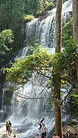 Main drop (lateral view)
 Staircase leading to the waterfall
References
- "Kintampo Waterfall". ghana.photographers-resource.com.
- "Kintampo Waterfalls". Ghana Tourism Authority. Archived from the original on 2012-06-17.
- "Kintampo Waterfalls". Wildlife and Nature Reserves. ghanaexpeditions.com. Archived from the original on 2016-08-25. Retrieved 2012-10-30.
- "tourism attractions". about this district. Kintampo North Municipal Assembly.
- WhiteOrange. "Brong Ahafo". Ghana Tourism Authourity. Retrieved 2020-01-31.
- "Ghana waterfall: Many dead in Kintampo freak tree accident". BBC News. 20 March 2017. Retrieved 21 March 2017.
- "Falling tree kills at least 18 at Ghana waterfall". Reuters. 20 March 2017. Retrieved 21 March 2017.
- https://citifmonline.com/2017/03/21/kintampo-waterfalls-closed-down-indefinitely/
This article is issued from Wikipedia. The text is licensed under Creative Commons - Attribution - Sharealike. Additional terms may apply for the media files.