King's Highway (Charleston to Boston)
The King's Highway was a roughly 1,300-mile (2,100 km) road laid out from 1650 to 1735 in the American colonies. It was built on the order of Charles II of England, who directed his colonial governors to link Charleston, South Carolina, and Boston, Massachusetts.
| King's Highway | |
|---|---|
| Route information | |
| Length | 1,300 mi (2,100 km) |
| Existed | Late 1600s–1800s |
| Major junctions | |
| From | Charleston, SC |
| To | Boston, MA |
| Highway system | |
| Post Roads in the United States | |
The section north of New York City, laid out on January 22, 1673, became the Upper Boston Post Road.[1] The road was finally completed in 1735.
From Virginia southward, the modern U.S. 17 has many segments that follow the old King's Highway.
Mail delivery in the Northeast
_-_Geographicus_-_NewEnglandNewYork-moll-1729.jpg)
Herman Moll's 1729 "Post Map" described the route:
An account of ye Post of ye Continent of Nth. America as they were regulated by ye Postmaster Genl. of ye Post House. The Western Posts setts out from Philadelphia and arrives at New York Saturday night; the distance between Philadelphia & New York being 106 Miles. The Post goes Eastward every Monday morning from New York and arrives at Seabrook Thursday noon.; being 150 Miles the Post setts out from Boston at the same time; the New York Post returns with the Eastern Letters, and the Boston Post with the Western. Bags are dropt at New London, Stommington, Rhode Island, and Bristol. The Post from Boston to Pisacataway being 70 Miles leaves Letters at Ipswich, Salem, Marblehead, Newberry. There are offices kept at Burlington, Perth Amboy, New Jersey, New London and Stommington in Connecticott, at Rhode Island, Bristol, Ipswich, Salem, Marblehead, & Newberry. and the 3 great offices are Boston, New York, and Philadelphia.[2]
Boston Post Road
The Boston Post Road was a system of mail-delivery routes between New York City and Boston that evolved into the first major highways in the United States. Some routes followed trails in use by Native Americans long before Europeans arrived. Some of these important native trails had been used long enough that they were two feet below the surrounding woodland.[3]
Following a trail known as the Pequot Path, the Upper Post Road was first laid out on January 1, 1673.[4] Used by post riders to deliver the mail, it was later widened and smoothed so that horse-drawn wagons or stagecoaches could use it. During the 19th century, turnpike companies took over and improved pieces of the road. Large sections of the various routes are still called the King's Highway and Boston Post Road. Much of the Post Road is now U.S. Route 1, and U.S. Route 20.
Route of the King's Highway
|
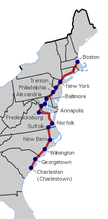 A map of the King's Highway showing modern state borders.
|
Gallery
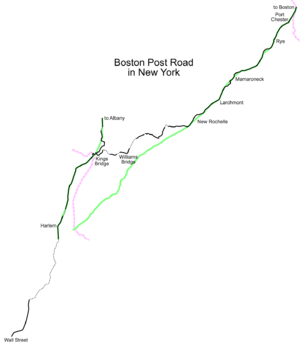 The Post Road in New York
 Milestone 8 on the Upper Post Road in Harvard Square
See also
- List of roads and highways
- Washington-Rochambeau Revolutionary Route
- Assunpink Trail
- King's Highway Historic District
References
- Map Guide to American Migration Routes, 1735–1815 by William Dollarhide, Heritage Quest, 1997, ISBN 1-877677-74-4
-

- Bourne, p.13
- Daughters of the American Revolution Magazine, January 1917, Vol. 50, page 386,
External links
- King’s Road
- Locating the Old Wagon Roads
- Washington-Rochambeau Revolutionary Route
- "JERSEY; In Praise of New Jersey's Highways. Honest. - New York Times". nytimes.com. Retrieved 19 January 2014.