Kinburn Peninsula
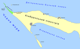
The Kinburn Peninsula (Ukrainian: Кінбурнський півострів, Kinburns'kii pivostriv), a peninsula in Southern Ukraine, separates the Dnieper-Bug Estuary from the Black Sea. Administratively the peninsula is divided between two regions each represented by one rural community: Pokrovske (Mykolaiv Oblast) and Heroiske (Kherson Oblast).
| Native name: Кінбурнський півострів | |
|---|---|
 | |
| Etymology | Turkish: Kılburun |
| Geography | |
| Coordinates | 46.507555°N 31.778783°E |
| Length | 40 km (25 mi)[1] |
| Width | 10 km (6 mi) |
| Administration | |
Ukraine | |
| Oblast | Mykolaiv |
| Oblast | Kherson |
| Largest settlement | village Heroiske, Hola Prystan Raion |
| Demographics | |
| Population | 1,450 |
The western tip of the peninsula extends into the Kinburn Foreland (spit).
To the south are located couple of islands, Dovhyi and Kruhlyi - both belong administratively to the Ochakiv Raion of Mykolaiv Oblast.[2]
The Battle of Kinburn was fought on 17 October 1855 as part of the Crimean War.
References
- Land of Achilles and Prince Svyatoslav. Svyatoslav's White Coast National Park website.
- Black Sea islands of Mykolaiv Oblast
This article is issued from Wikipedia. The text is licensed under Creative Commons - Attribution - Sharealike. Additional terms may apply for the media files.