Khunyang Chhish
Khunyang Chhish or Kunyang Chhish (Urdu: کنیانگ چش)is the second-highest mountain in the Hispar Muztagh, a subrange of the Karakoram mountains in Pakistan. Alternate variations of the name include Kunyang Kish and Khiangyang Kish, among others. Its height, also sometimes given as 7,823 metres (25,666 ft), is ranked 21st in the world and 8th in Pakistan (in a disputed territory).
| Khunyang Chhish کنیانگ چش | |
|---|---|
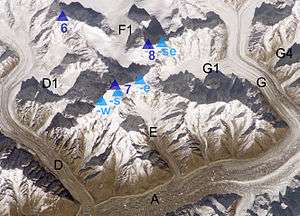 Khunyang Chhish (centre left) and Hispar glacier (below) - NASA ISS image | |
| Highest point | |
| Elevation | 7,852 m (25,761 ft) [1] Ranked 21st |
| Prominence | 1,765 m (5,791 ft) [1] |
| Listing | Ultra |
| Coordinates | 36°12′19″N 75°12′28″E [2] |
| Geography | |
 Khunyang Chhish کنیانگ چش  Khunyang Chhish کنیانگ چش Khunyang Chhish کنیانگ چش (Gilgit Baltistan) | |
| Parent range | Hispar Muztagh, Karakoram |
| Climbing | |
| First ascent | August 26, 1971 by Andrzej Heinrich, Jan Stryczynski, Ryszard Szafirski, Andrzej Zawada |
| Easiest route | glacier/rock/ice climb |
Location
Khunyang Chhish lies in the heart of the Hispar Muztagh, north of the Hispar Glacier, one of the major glaciers of the Karakoram. It rises on the southwest side of the Khunyang Glacier while Distaghil Sar (the highest peak of the Hispar Muztagh) dominates the glacier on its northern end.
Notable features
Khunyang Chhish is the twenty-first-highest independent mountain in the world. It is also notable for its rise above local terrain: for example, it rises almost 4,000 metres (13,000 ft) above its southern base camp on the Khunyang Glacier, and it rises 5,500 metres (3.4 mi) above the Hunza valley in about 33 kilometres (108,000 ft). It is a steep, pointed, and complex peak; it easily rivals the slightly higher Distaghil Sar to the North, which has a more rounded profile.
Not counting the two Pumari Chhish summits 4 kilometres (2.5 mi) to the ENE, the Kunyang Chhish massive has five peaks:
- Kunyang Chhish Main, 7,852 metres (25,761 ft)
- Kunyang Chhish South, 7,620 metres (25,000 ft), 700 m SSW, with a prominence of only about 100 metres (330 ft)
- Kunyang Chhish East 7,400 metres (24,300 ft), 2 km ESE, 240-metre (790 ft) prominence.
- Kunyang Chhish West, 7,350 metres (24,110 ft), 1.5 km W, 170-metre (560 ft) prominence. Also known as Pyramid Peak.
- Kunyang Chhish North, 7,108 metres (23,320 ft), 6 km NNE, 517-metre (1,696 ft) prominence.

Climbing history
The first climbing attempt on Khunyang Chhish was made in 1962 but the climb was aborted after an avalanche on 18 July killed two climbers, Major James Mills and Captain M. R. F. Jones. Their bodies were never recovered.
The next attempt was in 1965 by a Japanese party mainly consists of the University of Tokyo members. They chose the south ridge of Khunyang Chhish, but another climber Takeo Nakamura died after the collapse of a narrow ridge at 7,200 m (23,600 ft).
The first ascent was accomplished by a Polish team led by Andrzej Zawada in 1971. They climbed a long route up the South Ridge of the peak from the Pumari Chhish Glacier. However, one of their members was killed in a crevasse accident.
The second, and only other recorded ascent, climbed the Northwest Spur to the North Ridge. Two British climbers, Mark Lowe and Keith Milne, completed this route on July 11, 1988. The route had first been attempted in 1980, and had been attempted again in 1981, 1982 and 1987.
The Himalayan Index lists three recent attempts on this peak, in 2000 and 2003.
After four failed expeditions, starting in 2003, the East summit was first ascended in July 2013 by an Austrian/Swiss team over the South Wall.
See also
- List of mountains in Pakistan
- Gilgit-Baltistan, Pakistan
- Highest mountains of the World
- List of Ultras of the Karakoram and Hindu Kush
References
- "Kunyang Chhish" on Peakbagger Retrieved 25 September 2011
- Khunyang Chhish on bbs.keyhole.com
- Jill Neate, High Asia: An Illustrated History of the 7000 Metre Peaks, ISBN 0-89886-238-8
- Orographical Sketch Map of the Karakoram by Jerzy Wala, 1990. Published by the Swiss Foundation for Alpine Research.
- Andy Fanshawe and Stephen Venables, Himalaya Alpine-Style, Hodder and Stoughton, 1995.
- American Alpine Journal
- Himalayan Index
- DEM files for the Himalaya (Corrected versions of SRTM data)
- Khunyang Chhish on Peakware
- A list of world peaks ranked by local relief and steepness which includes Khunyang Chhish
External links
Kunyang Chhish North. A Japanese expedition from Hokkaido University in 1979 was led by Kohei Echizenya climbed the north ridge of Kunyang Chhish (23,321 feet) to make the first ascent. Base Camp was placed on the Kunyang Glacier at 14,300 feet on June 17. They followed the same route as the expedition to Pumari Chhish as far as the north col. Three camps, the highest Camp IV at 22,000 feet, were established on the north ridge. All eight climbers got to the summit on July 11.