Khatanga, Russia
Khatanga (Russian: Хатанга) is a rural locality (a selo) in Taymyrsky Dolgano-Nenetsky District of Krasnoyarsk Krai, Russia, located on the Khatanga River on the Taymyr Peninsula. It is one of the northernmost inhabited localities in Russia. Its elevation is 30 metres (98 ft) above sea level. As of the 2002 Census, its population was 3,450.[3]
Khatanga Хатанга | |
|---|---|
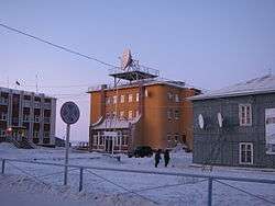 Khatanga Post Office | |
Location of Khatanga 
| |
 Khatanga Location of Khatanga 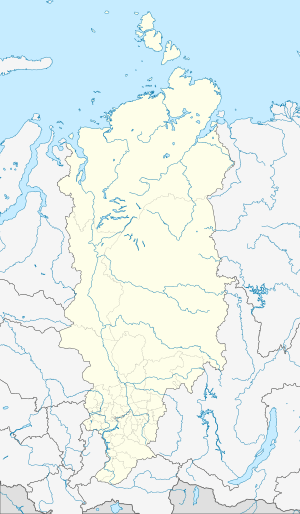 Khatanga Khatanga (Krasnoyarsk Krai) | |
| Coordinates: 71°58′47″N 102°28′22″E | |
| Country | Russia |
| Federal subject | Krasnoyarsk Krai |
| Administrative district | Taymyrsky Dolgano-Nenetsky District |
| • Municipal district | Taymyrsky Dolgano-Nenetsky Municipal District |
| • Rural settlement | Khatanga Rural Settlement |
| • Capital of | Khatanga Rural Settlement |
| Time zone | UTC+7 (MSK+4 |
| Postal code(s)[2] | 647460, 647462 |
| OKTMO ID | 04653419101 |
The name Khatanga means "large water" in the local Evenki language. The locality is known to have existed since the 17th century. It is served by the Khatanga Airport.
Khatanga is sometimes visited by Western sightseers touring the surrounding natural wilderness in Siberia. Khatanga has a hotel, a natural history museum, and weather reporting stations.
Khatanga is relatively close to the Popigai crater, an asteroid crater and geological formation located in northern Siberia. The crater has been noted since September 2012 as a potential source of a significant new global supply of industrial diamonds.
Climate
Khatanga has a subarctic climate (Köppen climate classification Dfc) with short, mild summers and bitterly cold winters. Precipitation is quite low, but is somewhat heavier in summer, when it falls mostly as rain, than in the rest of the year, when it falls mostly as snow.
| Climate data for Khatanga | |||||||||||||
|---|---|---|---|---|---|---|---|---|---|---|---|---|---|
| Month | Jan | Feb | Mar | Apr | May | Jun | Jul | Aug | Sep | Oct | Nov | Dec | Year |
| Record high °C (°F) | −2.4 (27.7) |
−0.2 (31.6) |
3.8 (38.8) |
8.8 (47.8) |
25.6 (78.1) |
32.9 (91.2) |
36.7 (98.1) |
29.9 (85.8) |
24.2 (75.6) |
11.9 (53.4) |
2.3 (36.1) |
−0.2 (31.6) |
36.7 (98.1) |
| Average high °C (°F) | −27.6 (−17.7) |
−27.7 (−17.9) |
−21 (−6) |
−11.6 (11.1) |
−2.2 (28.0) |
9.9 (49.8) |
17.2 (63.0) |
13.7 (56.7) |
4.9 (40.8) |
−8.5 (16.7) |
−20.8 (−5.4) |
−25.5 (−13.9) |
−8.3 (17.1) |
| Daily mean °C (°F) | −31.5 (−24.7) |
−31.7 (−25.1) |
−26.1 (−15.0) |
−17.3 (0.9) |
−6.2 (20.8) |
5.7 (42.3) |
12.5 (54.5) |
9.4 (48.9) |
1.8 (35.2) |
−11.8 (10.8) |
−24.6 (−12.3) |
−29.5 (−21.1) |
−12.4 (9.7) |
| Average low °C (°F) | −35.5 (−31.9) |
−35.3 (−31.5) |
−30.6 (−23.1) |
−22.5 (−8.5) |
−10.1 (13.8) |
2.6 (36.7) |
8.6 (47.5) |
5.8 (42.4) |
−0.9 (30.4) |
−15.1 (4.8) |
−28.3 (−18.9) |
−33.4 (−28.1) |
−16.2 (2.8) |
| Record low °C (°F) | −59 (−74) |
−55.9 (−68.6) |
−52.4 (−62.3) |
−42.9 (−45.2) |
−30.9 (−23.6) |
−14.3 (6.3) |
−0.7 (30.7) |
−3.2 (26.2) |
−18.6 (−1.5) |
−39.9 (−39.8) |
−51 (−60) |
−58.7 (−73.7) |
−59.0 (−74.2) |
| Average precipitation mm (inches) | 14 (0.6) |
11 (0.4) |
14 (0.6) |
14 (0.6) |
17 (0.7) |
29 (1.1) |
41 (1.6) |
43 (1.7) |
31 (1.2) |
29 (1.1) |
21 (0.8) |
19 (0.7) |
283 (11.1) |
| Average rainy days | 0.03 | 0 | 0.03 | 1 | 5 | 15 | 17 | 19 | 16 | 3 | 0.1 | 0.1 | 76 |
| Average snowy days | 21 | 22 | 20 | 20 | 20 | 9 | 1 | 1 | 14 | 26 | 24 | 22 | 200 |
| Average relative humidity (%) | 77 | 78 | 78 | 78 | 79 | 73 | 70 | 78 | 83 | 84 | 81 | 77 | 78 |
| Mean monthly sunshine hours | 0 | 23 | 151 | 267 | 264 | 262 | 308 | 195 | 88 | 43 | 3 | 0 | 1,604 |
| Source 1: Pogoda.ru.net[4] | |||||||||||||
| Source 2: NOAA (sun only, 1961-1990)[5] | |||||||||||||
References
- "Об исчислении времени". Официальный интернет-портал правовой информации (in Russian). June 3, 2011. Retrieved January 19, 2019.
- Почта России. Информационно-вычислительный центр ОАСУ РПО. (Russian Post). Поиск объектов почтовой связи (Postal Objects Search) (in Russian)
- Russian Federal State Statistics Service (May 21, 2004). "Численность населения России, субъектов Российской Федерации в составе федеральных округов, районов, городских поселений, сельских населённых пунктов – районных центров и сельских населённых пунктов с населением 3 тысячи и более человек" [Population of Russia, Its Federal Districts, Federal Subjects, Districts, Urban Localities, Rural Localities—Administrative Centers, and Rural Localities with Population of Over 3,000] (XLS). Всероссийская перепись населения 2002 года [All-Russia Population Census of 2002] (in Russian).
- "Pogoda.ru.net - Climate Data for Hatanga" (in Russian). Retrieved February 27, 2016.
- "Hatanga Climate Normals 1961-1990". National Oceanic and Atmospheric Administration. Retrieved February 27, 2016.